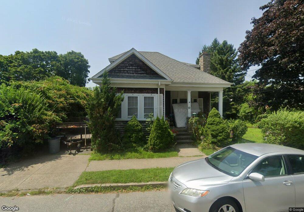
10 Francis St Fairhaven, MA 02719
Estimated Value: $528,000 - $653,000
5
Beds
2
Baths
2,122
Sq Ft
$266/Sq Ft
Est. Value
About This Home
This home is located at 10 Francis St, Fairhaven, MA 02719 and is currently estimated at $564,725, approximately $266 per square foot. 10 Francis St is a home located in Bristol County with nearby schools including Fairhaven High School, City On A Hill Charter Public School New Bedford, and St. Joseph School.
Ownership History
Date
Name
Owned For
Owner Type
Purchase Details
Closed on
Oct 26, 2016
Sold by
Letoile Andrew J and Buchanan Amie M
Bought by
Letoile Amie M and Letoile Andrew J
Current Estimated Value
Purchase Details
Closed on
Jul 20, 2011
Sold by
Lucille J Letoile Irt and Schneider Nina C
Bought by
Letoile Andrew J and Buchanan Amie M
Home Financials for this Owner
Home Financials are based on the most recent Mortgage that was taken out on this home.
Original Mortgage
$197,455
Interest Rate
3.87%
Mortgage Type
FHA
Purchase Details
Closed on
Jan 3, 2005
Sold by
Letoile Ft and Schneider Nina C
Bought by
Letoile Lucille J
Home Financials for this Owner
Home Financials are based on the most recent Mortgage that was taken out on this home.
Original Mortgage
$125,000
Interest Rate
5.73%
Mortgage Type
Purchase Money Mortgage
Create a Home Valuation Report for This Property
The Home Valuation Report is an in-depth analysis detailing your home's value as well as a comparison with similar homes in the area
Home Values in the Area
Average Home Value in this Area
Purchase History
| Date | Buyer | Sale Price | Title Company |
|---|---|---|---|
| Letoile Amie M | -- | -- | |
| Letoile Andrew J | -- | -- | |
| Letoile Lucille J | -- | -- |
Source: Public Records
Mortgage History
| Date | Status | Borrower | Loan Amount |
|---|---|---|---|
| Previous Owner | Letoile Andrew J | $197,455 | |
| Previous Owner | Letoile Lucille J | $125,000 |
Source: Public Records
Tax History Compared to Growth
Tax History
| Year | Tax Paid | Tax Assessment Tax Assessment Total Assessment is a certain percentage of the fair market value that is determined by local assessors to be the total taxable value of land and additions on the property. | Land | Improvement |
|---|---|---|---|---|
| 2025 | $36 | $382,400 | $182,900 | $199,500 |
| 2024 | $3,439 | $372,600 | $182,900 | $189,700 |
| 2023 | $3,441 | $345,800 | $169,500 | $176,300 |
| 2022 | $3,312 | $324,100 | $161,500 | $162,600 |
| 2021 | $3,072 | $272,100 | $146,800 | $125,300 |
| 2020 | $2,935 | $265,400 | $140,100 | $125,300 |
| 2019 | $2,831 | $242,600 | $127,600 | $115,000 |
| 2018 | $2,786 | $232,600 | $121,500 | $111,100 |
| 2017 | $2,735 | $227,200 | $121,500 | $105,700 |
| 2016 | $2,659 | $218,300 | $121,500 | $96,800 |
| 2015 | $2,637 | $217,000 | $121,500 | $95,500 |
Source: Public Records
Map
Nearby Homes
- 64 Bridge St
- 39 Huttleston Ave
- 43 Huttleston Ave
- 70 Bridge St
- 9 Francis St
- 37 Huttleston Ave
- 45 Huttleston Ave
- Lot 000 Bridge St
- 63 Bridge St
- 47 Huttleston Ave
- 74 Bridge St
- 69 Bridge St
- 33 Huttleston Ave
- 67 Bridge St
- 40 Huttleston Ave
- 37 Mulberry St
- 42 Huttleston Ave
- 42 Huttleston Ave
- 51 Huttleston Ave
- 31 Huttleston Ave