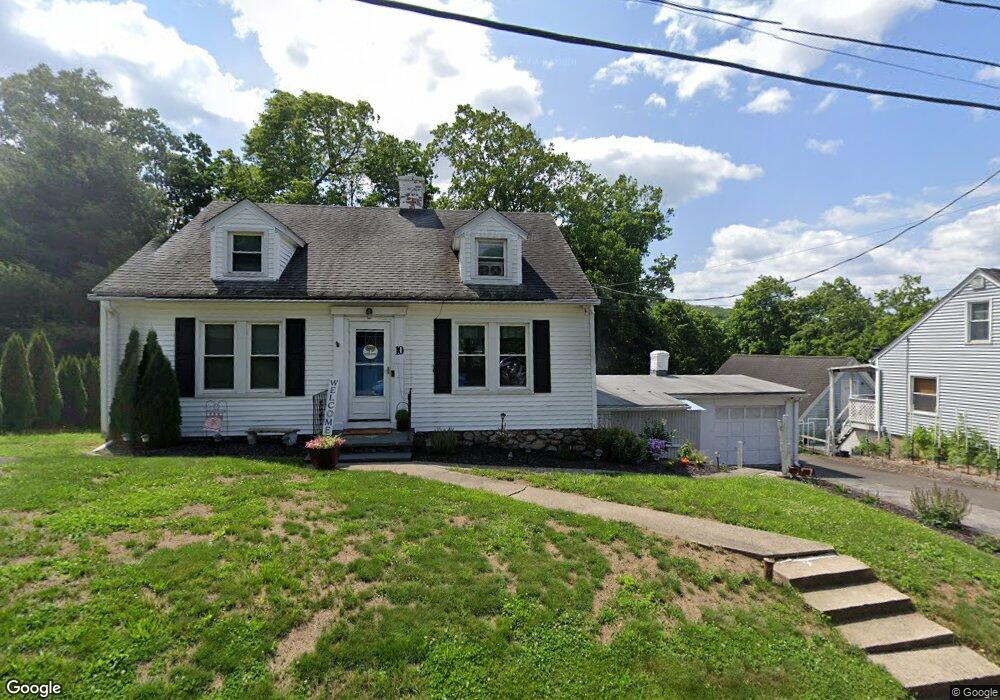
10 Gilyard St Seymour, CT 06483
Estimated Value: $290,000 - $387,000
2
Beds
1
Bath
1,254
Sq Ft
$280/Sq Ft
Est. Value
About This Home
This home is located at 10 Gilyard St, Seymour, CT 06483 and is currently estimated at $351,308, approximately $280 per square foot. 10 Gilyard St is a home located in New Haven County with nearby schools including Seymour Middle School, Seymour High School, and Assumption School.
Ownership History
Date
Name
Owned For
Owner Type
Purchase Details
Closed on
Jul 26, 2023
Sold by
Vereb Scott M
Bought by
Scott M Vereb Lt and Vereb
Current Estimated Value
Purchase Details
Closed on
Jun 17, 2009
Sold by
Clancy Kathleen M and Clancy Edward J
Bought by
Vereb Scott M
Home Financials for this Owner
Home Financials are based on the most recent Mortgage that was taken out on this home.
Original Mortgage
$152,000
Interest Rate
4.91%
Mortgage Type
Purchase Money Mortgage
Create a Home Valuation Report for This Property
The Home Valuation Report is an in-depth analysis detailing your home's value as well as a comparison with similar homes in the area
Home Values in the Area
Average Home Value in this Area
Purchase History
| Date | Buyer | Sale Price | Title Company |
|---|---|---|---|
| Scott M Vereb Lt | -- | None Available | |
| Scott M Vereb Lt | -- | None Available | |
| Vereb Scott M | $190,000 | -- | |
| Vereb Scott M | $190,000 | -- |
Source: Public Records
Mortgage History
| Date | Status | Borrower | Loan Amount |
|---|---|---|---|
| Previous Owner | Vereb Scott M | $156,000 | |
| Previous Owner | Vereb Scott M | $152,000 |
Source: Public Records
Tax History Compared to Growth
Tax History
| Year | Tax Paid | Tax Assessment Tax Assessment Total Assessment is a certain percentage of the fair market value that is determined by local assessors to be the total taxable value of land and additions on the property. | Land | Improvement |
|---|---|---|---|---|
| 2025 | $5,854 | $211,190 | $44,800 | $166,390 |
| 2024 | $5,671 | $153,930 | $35,070 | $118,860 |
| 2023 | $5,538 | $153,930 | $35,070 | $118,860 |
| 2022 | $5,478 | $153,930 | $35,070 | $118,860 |
| 2021 | $5,343 | $153,930 | $35,070 | $118,860 |
| 2020 | $4,702 | $130,620 | $41,230 | $89,390 |
| 2019 | $4,702 | $130,620 | $41,230 | $89,390 |
| 2018 | $4,702 | $130,620 | $41,230 | $89,390 |
| 2017 | $4,702 | $130,620 | $41,230 | $89,390 |
| 2016 | $4,702 | $130,620 | $41,230 | $89,390 |
| 2015 | $4,731 | $136,780 | $43,400 | $93,380 |
| 2014 | $4,656 | $136,780 | $43,400 | $93,380 |
Source: Public Records
Map
Nearby Homes
- 10 Highland Ave
- 32 Roberts St
- 31 Skokorat St
- 226 Walnut St
- 6/6A Chatfield St
- 27 Wood St
- 38 Sanford St
- 17 Meadow St Unit 23
- 35 Cogwheel Ln
- 26-28 S Main St
- 9 Wooster St
- 77 S Main St
- 60 Acorn Hill Rd
- 28 Charles Rd
- 58 Acorn Hill Rd
- 17 Warren Dr
- 61 Pershing Ave
- 139 Derby Ave
- 202 W Church St
- 169 Derby Ave