
Seller's Agent in 2025
Nadia Burza
CHARLES RUTENBERG REALTY ORLANDO
(407) 314-1767
5 in this area
88 Total Sales
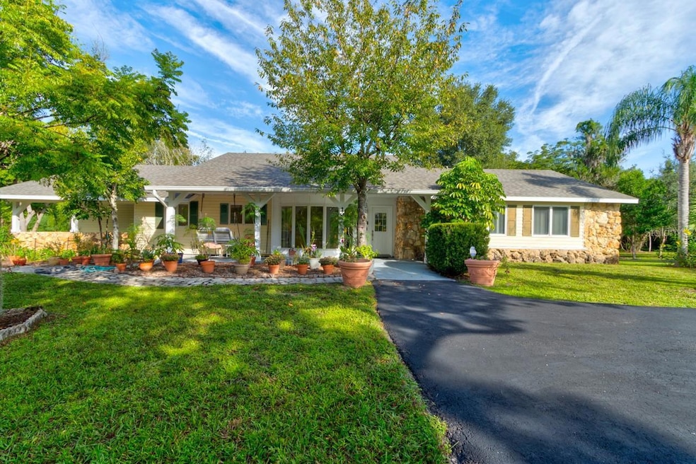
Welcome Home to this well-maintained and charming house with A BRAND NEW ROOF, 4 -bedrooms, 3-baths, that sits on 1.69 private acres, and includes a fully functional mother-in-law suite. The suite features its own kitchen, private entrance and a carport, making it ideal for extended family or as a POTENTIAL INCOME PRODUCING RENTAL. No HOA
The property is fully fenced with a private gated entrance, offering both security and seclusion. With 1.69 acres of land, there’s ample space for gardening, outdoor activities, or even future expansions — endless potential for how you want to enjoy it. Two garden ponds and mature bamboo add to the serene atmosphere.
Car enthusiasts or those needing extra storage will love the detached 4-car tandem garage. Spacious and versatile, it provides plenty of room for vehicles, a workshop, or hobby space
A spacious front porch welcomes you inside, where a large bay window fills the kitchen with natural light. The kitchen boasts upgraded countertops, an island with cooktop, and plenty of room for entertaining. The living room features a cozy fireplace, which flows seamlessly into the spacious dining area. The bedrooms are thoughtfully placed, with the primary suite located on the far right side of the home for added privacy.
Additional highlights include: •Portable generator, powers most of the home (excluding AC and range), offering added security and functionality during those hurricane outages. • Septic system (pumped July 2024; leach field replaced Nov. 2014) • Roof replaced Aug. 18, 2025 • Plumbing: copper & PVC • Electrical panel replaced 2002 • Termite bond with West Pest, Termidor treatment — transferable
Appliance updates:
• Washer (Dec. 2022)
• Dryer (Sept. 2024)
• Apartment stove (Jan. 2025)
• Apartment refrigerator (Jan. 2025)
• Garage door opener replaced Aug. 2025
This home offers charm, functionality, and peace of mind with major systems updated and transferable warranties in place — all while giving you the added benefit of privacy, security, and room to grow on nearly two acres of land. PROPERTY UNDER AUDIO VIDEO SURVEILLANCE.
Last Agent to Sell the Property
CHARLES RUTENBERG REALTY ORLANDO Brokerage Phone: 407-622-2122 License #3295139 Listed on: 09/23/2025
| Date | Type | Sale Price | Title Company |
|---|---|---|---|
| Warranty Deed | $458,000 | Legacy Title | |
| Warranty Deed | -- | -- | |
| Warranty Deed | $89,500 | -- | |
| Deed | $9,000 | -- | |
| Deed | $7,000 | -- |
| Date | Status | Loan Amount | Loan Type |
|---|---|---|---|
| Open | $435,100 | New Conventional | |
| Previous Owner | $80,550 | No Value Available |
| Date | Event | Price | List to Sale | Price per Sq Ft |
|---|---|---|---|---|
| 10/28/2025 10/28/25 | Sold | $458,000 | +0.7% | $177 / Sq Ft |
| 09/29/2025 09/29/25 | Pending | -- | -- | -- |
| 09/23/2025 09/23/25 | For Sale | $455,000 | -- | $176 / Sq Ft |
| Year | Tax Paid | Tax Assessment Tax Assessment Total Assessment is a certain percentage of the fair market value that is determined by local assessors to be the total taxable value of land and additions on the property. | Land | Improvement |
|---|---|---|---|---|
| 2026 | $2,601 | $376,111 | $142,136 | $233,975 |
| 2025 | $2,601 | $164,803 | -- | -- |
| 2024 | $2,368 | $160,159 | -- | -- |
| 2023 | $2,368 | $155,495 | $0 | $0 |
| 2022 | $2,310 | $150,966 | $0 | $0 |
| 2021 | $2,361 | $146,569 | $0 | $0 |
| 2020 | $2,347 | $144,545 | $0 | $0 |
| 2019 | $2,383 | $141,295 | $0 | $0 |
| 2018 | $2,310 | $138,660 | $0 | $0 |
| 2017 | $2,333 | $135,808 | $0 | $0 |
| 2016 | $2,252 | $133,015 | $0 | $0 |
| 2015 | $2,297 | $132,090 | $0 | $0 |
| 2014 | $2,260 | $131,042 | $0 | $0 |
Seller's Agent in 2025
Nadia Burza
CHARLES RUTENBERG REALTY ORLANDO
(407) 314-1767
5 in this area
88 Total Sales
Buyer's Agent in 2025
Chris Creegan
CREEGAN GROUP
(407) 622-1111
7 in this area
1,670 Total Sales
R
Buyer Co-Listing Agent in 2025
RJ Adams
CREEGAN GROUP
(407) 622-1111
1 in this area
87 Total Sales
Source: Stellar MLS
MLS Number: O6346567
APN: 8032-01-00-0690
Disclaimer: Certain information contained herein is derived from information provided by parties other than Homes.com. All information provided is deemed reliable, but is not guaranteed to be accurate and should be independently verified.
![]() IDX information is provided exclusively for personal, non-commercial use, and may not be used for any purpose other than to identify prospective properties consumers may be interested in purchasing. Information is deemed reliable but not guaranteed.
IDX information is provided exclusively for personal, non-commercial use, and may not be used for any purpose other than to identify prospective properties consumers may be interested in purchasing. Information is deemed reliable but not guaranteed.
Listing Information presented by local MLS brokerage: Ten-X - (888)-952-6393