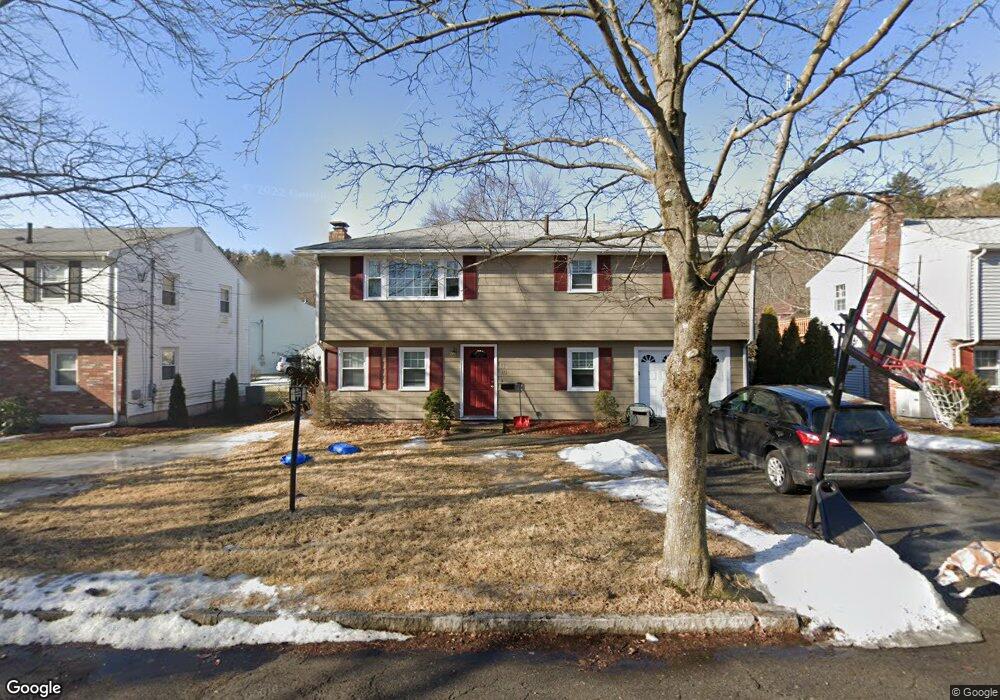
10 Groveland Rd Melrose, MA 02176
Oak Grove-Pine Banks NeighborhoodEstimated Value: $693,000 - $789,000
2
Beds
2
Baths
1,672
Sq Ft
$447/Sq Ft
Est. Value
About This Home
This home is located at 10 Groveland Rd, Melrose, MA 02176 and is currently estimated at $746,634, approximately $446 per square foot. 10 Groveland Rd is a home located in Middlesex County with nearby schools including Lincoln Elementary School, Winthrop Elementary School, and Horace Mann Elementary School.
Ownership History
Date
Name
Owned For
Owner Type
Purchase Details
Closed on
Sep 1, 2011
Sold by
10 Groveland Road Rt
Bought by
Jangro Bruce and Jangro Gail
Current Estimated Value
Home Financials for this Owner
Home Financials are based on the most recent Mortgage that was taken out on this home.
Original Mortgage
$311,888
Outstanding Balance
$216,213
Interest Rate
4.52%
Mortgage Type
Purchase Money Mortgage
Estimated Equity
$530,421
Purchase Details
Closed on
Jul 29, 1988
Sold by
Sica Ernest D
Bought by
Sica Maria S
Create a Home Valuation Report for This Property
The Home Valuation Report is an in-depth analysis detailing your home's value as well as a comparison with similar homes in the area
Home Values in the Area
Average Home Value in this Area
Purchase History
| Date | Buyer | Sale Price | Title Company |
|---|---|---|---|
| Jangro Bruce | $320,000 | -- | |
| Sica Maria S | $66,000 | -- |
Source: Public Records
Mortgage History
| Date | Status | Borrower | Loan Amount |
|---|---|---|---|
| Open | Jangro Bruce | $311,888 |
Source: Public Records
Tax History Compared to Growth
Tax History
| Year | Tax Paid | Tax Assessment Tax Assessment Total Assessment is a certain percentage of the fair market value that is determined by local assessors to be the total taxable value of land and additions on the property. | Land | Improvement |
|---|---|---|---|---|
| 2025 | $60 | $605,900 | $428,200 | $177,700 |
| 2024 | $5,743 | $578,300 | $400,600 | $177,700 |
| 2023 | $5,676 | $544,700 | $372,900 | $171,800 |
| 2022 | $5,513 | $521,600 | $359,100 | $162,500 |
| 2021 | $5,586 | $510,100 | $359,100 | $151,000 |
| 2020 | $5,332 | $482,500 | $331,500 | $151,000 |
| 2019 | $4,802 | $444,200 | $303,900 | $140,300 |
| 2018 | $4,370 | $385,700 | $252,100 | $133,600 |
| 2017 | $4,429 | $375,300 | $241,700 | $133,600 |
| 2016 | $4,011 | $325,300 | $207,200 | $118,100 |
| 2015 | $4,081 | $314,900 | $196,800 | $118,100 |
| 2014 | $3,953 | $297,700 | $179,600 | $118,100 |
Source: Public Records
Map
Nearby Homes
- 161 Washington St
- 9 Crescent Ave
- 407 Pleasant St Unit 1A
- 447 Pleasant St
- 12 Sylvan St Unit 4
- 12 Sylvan St Unit 3
- 35-41 Brazil St
- 23 Waverly Place
- 36 Waverly Place Unit 2
- 359 Washington St
- 22 Adams St
- 12 Mount Vernon St Unit 27
- 333 Main St
- 16 Baxter St
- 20 Herbert St
- 59 Sanford St
- 16 Willow St Unit 207
- 16-18 Beacon Place
- 38 Greystone Rd
- 921 Main St
- 14 Groveland Rd
- 16 Groveland Rd
- 4 Groveland Rd
- 60 Converse Ln
- 20 Groveland Rd
- 9 Groveland Rd
- 201 Washington St
- 207 Washington St
- 3 Groveland Rd
- 5 Black Rock Rd
- 24 Groveland Rd
- 197 Washington St
- 56 Converse Ln
- 65 Converse Ln
- 211 Washington St
- 71 Converse Ln
- 57 Converse Ln
- 189 Washington St
- 82 Converse Ln
- 75 Converse Ln