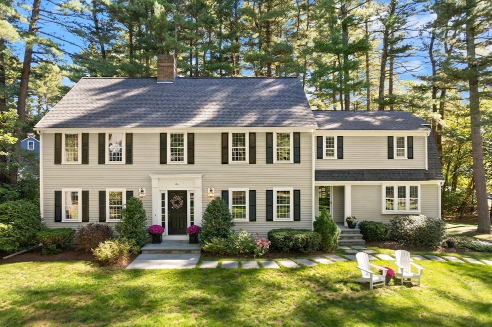
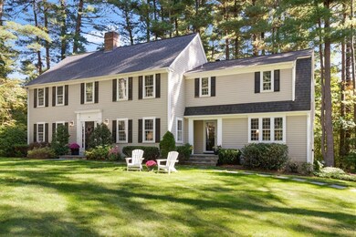
10 Hammond Cir Sudbury, MA 01776
Estimated payment $9,058/month
Highlights
- Golf Course Community
- Community Stables
- Scenic Views
- Israel Loring Elementary School Rated A-
- Medical Services
- Open Floorplan
About This Home
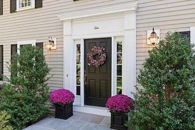
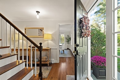
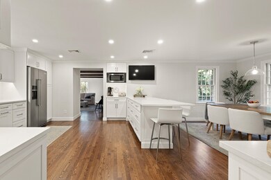
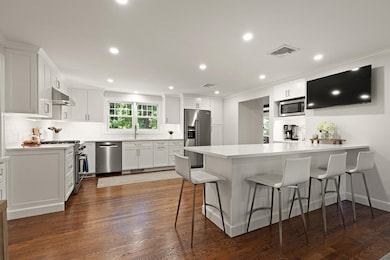
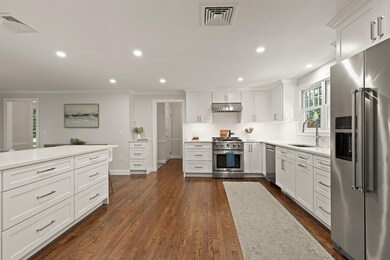
Celebrate the holidays in style in this magnificent colonial residence. Proudly situated on a spacious lot in a convenient south Sudbury neighborhood, this expertly maintained home offers the perfect blend of elegance and comfort. Featuring a spectacular and newly renovated white kitchen equipped with stainless steel appliances and quartz countertops. The cozy family room, complete with wood-beamed ceilings and a wood fireplace, is perfect for gatherings, while the dedicated home office provides ample privacy. The beautiful front-to-back living room features a second fireplace and lovely built-in cabinetry, creating an ideal space for both socializing and quiet relaxation. The upper level boasts five bedrooms, including a primary suite with a full bathroom and three closets! Enjoy the outdoors from the comfort of your own home or take a short stroll to the nearby Mass Central Pedestrian Bike Trail, offering miles of enjoyment and exercise. An incredible home and neighborhood await!
Home Details
Home Type
- Single Family
Est. Annual Taxes
- $15,595
Year Built
- Built in 1969 | Remodeled
Lot Details
- 1.39 Acre Lot
- Fenced Yard
- Landscaped Professionally
- Corner Lot
- Gentle Sloping Lot
- Sprinkler System
- Wooded Lot
- Property is zoned RESC
Parking
- 2 Car Attached Garage
- Tuck Under Parking
- Driveway
- Open Parking
- Off-Street Parking
- Deeded Parking
Home Design
- Colonial Architecture
- Frame Construction
- Shingle Roof
- Concrete Perimeter Foundation
Interior Spaces
- Open Floorplan
- Crown Molding
- Beamed Ceilings
- Recessed Lighting
- Decorative Lighting
- Picture Window
- Insulated Doors
- Family Room with Fireplace
- 2 Fireplaces
- Living Room with Fireplace
- Dining Area
- Home Office
- Scenic Vista Views
- Storm Windows
Kitchen
- Stove
- Range
- Dishwasher
- Kitchen Island
- Solid Surface Countertops
Flooring
- Wood
- Ceramic Tile
Bedrooms and Bathrooms
- 5 Bedrooms
- Primary bedroom located on second floor
- Custom Closet System
- Dual Closets
- Pedestal Sink
- Bathtub with Shower
- Separate Shower
Laundry
- Dryer
- Washer
Unfinished Basement
- Walk-Out Basement
- Basement Fills Entire Space Under The House
- Interior Basement Entry
- Garage Access
- Laundry in Basement
Outdoor Features
- Deck
- Rain Gutters
Schools
- Israel Loring Elementary School
- Ephraim Curtis Middle School
- Lincoln-Sudbury High School
Utilities
- Central Air
- 1 Cooling Zone
- 3 Heating Zones
- Heating System Uses Natural Gas
- Baseboard Heating
- Gas Water Heater
- Private Sewer
Additional Features
- Energy-Efficient Thermostat
- Property is near schools
Listing and Financial Details
- Assessor Parcel Number 783261
Community Details
Overview
- No Home Owners Association
- Near Conservation Area
Amenities
- Medical Services
- Shops
Recreation
- Golf Course Community
- Tennis Courts
- Park
- Community Stables
- Jogging Path
- Bike Trail
Map
Home Values in the Area
Average Home Value in this Area
Tax History
| Year | Tax Paid | Tax Assessment Tax Assessment Total Assessment is a certain percentage of the fair market value that is determined by local assessors to be the total taxable value of land and additions on the property. | Land | Improvement |
|---|---|---|---|---|
| 2025 | $15,595 | $1,065,200 | $501,000 | $564,200 |
| 2024 | $15,040 | $1,029,400 | $486,600 | $542,800 |
| 2023 | $14,001 | $887,800 | $434,600 | $453,200 |
| 2022 | $13,866 | $768,200 | $398,600 | $369,600 |
| 2021 | $13,303 | $706,500 | $398,600 | $307,900 |
| 2020 | $13,035 | $706,500 | $398,600 | $307,900 |
| 2019 | $12,653 | $706,500 | $398,600 | $307,900 |
| 2018 | $12,755 | $711,400 | $424,200 | $287,200 |
| 2017 | $12,505 | $704,900 | $420,600 | $284,300 |
| 2016 | $12,109 | $680,300 | $404,600 | $275,700 |
| 2015 | $11,392 | $647,300 | $377,300 | $270,000 |
| 2014 | $11,366 | $630,400 | $366,200 | $264,200 |
Property History
| Date | Event | Price | List to Sale | Price per Sq Ft |
|---|---|---|---|---|
| 10/06/2025 10/06/25 | Pending | -- | -- | -- |
| 09/30/2025 09/30/25 | For Sale | $1,475,000 | -- | $447 / Sq Ft |
Purchase History
| Date | Type | Sale Price | Title Company |
|---|---|---|---|
| Deed | $365,000 | -- |
Mortgage History
| Date | Status | Loan Amount | Loan Type |
|---|---|---|---|
| Open | $493,100 | No Value Available | |
| Closed | $487,500 | No Value Available |
Source: MLS Property Information Network (MLS PIN)
MLS Number: 73437653
APN: SUDB-000005J-000000-000315
Disclaimer: Certain information contained herein is derived from information provided by parties other than Homes.com. All information provided is deemed reliable, but is not guaranteed to be accurate and should be independently verified.
![]() The property listing data and information, or the Images, set forth herein were provided to MLS Property Information Network, Inc. from third party sources, including sellers, lessors and public records, and were compiled by MLS Property Information Network, Inc. The property listing data and information, and the Images, are for the personal, non-commercial use of consumers having a good faith interest in purchasing or leasing listed properties of the type displayed to them and may not be used for any purpose other than to identify prospective properties which such consumers may have a good faith interest in purchasing or leasing. MLS Property Information Network, Inc. and its subscribers disclaim any and all representations and warranties as to the accuracy of the property listing data and information, or as to the accuracy of any of the Images, set forth herein.
The property listing data and information, or the Images, set forth herein were provided to MLS Property Information Network, Inc. from third party sources, including sellers, lessors and public records, and were compiled by MLS Property Information Network, Inc. The property listing data and information, and the Images, are for the personal, non-commercial use of consumers having a good faith interest in purchasing or leasing listed properties of the type displayed to them and may not be used for any purpose other than to identify prospective properties which such consumers may have a good faith interest in purchasing or leasing. MLS Property Information Network, Inc. and its subscribers disclaim any and all representations and warranties as to the accuracy of the property listing data and information, or as to the accuracy of any of the Images, set forth herein.
- 46 Robert Best Rd
- 143 Peakham Rd
- 54 Stone Rd
- 0 Robbins Rd
- 7 Saddle Ridge Rd
- 0 Boston Post Rd
- 25 Bridle Path
- 39 Austin Rd
- 89 Bridle Path
- 14 Tanbark Rd
- 73 Willow Rd
- 7 Adams Rd
- 24 Woodland Rd
- 97 Barton Dr
- 123 Dutton Rd
- 36 Surrey Ln
- 128 Nobscot Rd
- 1011 Boston Post Rd
- 270 Old Lancaster Rd
- 30 Nobscot Rd Unit 14
