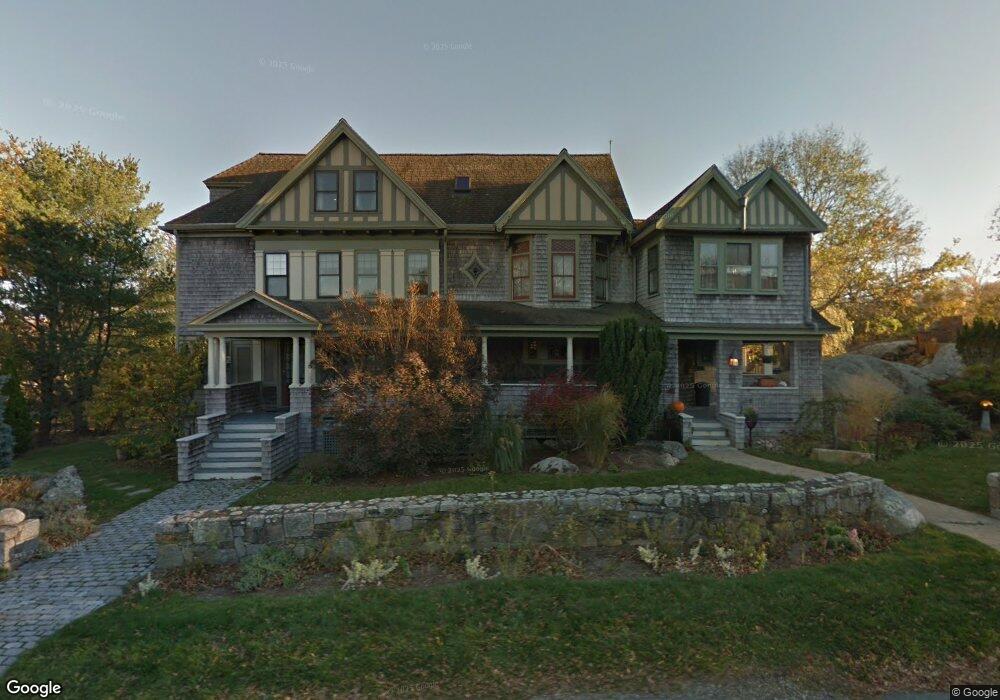
10 Harbor Rd Gloucester, MA 01930
East Gloucester NeighborhoodEstimated Value: $1,589,000 - $2,167,000
5
Beds
4
Baths
3,785
Sq Ft
$518/Sq Ft
Est. Value
About This Home
This home is located at 10 Harbor Rd, Gloucester, MA 01930 and is currently estimated at $1,959,454, approximately $517 per square foot. 10 Harbor Rd is a home located in Essex County with nearby schools including East Gloucester Elementary School, Ralph B O'maley Middle School, and Gloucester High School.
Ownership History
Date
Name
Owned For
Owner Type
Purchase Details
Closed on
Sep 18, 1992
Sold by
Scenna Lucille
Bought by
Poore Patricia
Current Estimated Value
Home Financials for this Owner
Home Financials are based on the most recent Mortgage that was taken out on this home.
Original Mortgage
$190,000
Interest Rate
8.04%
Mortgage Type
Purchase Money Mortgage
Create a Home Valuation Report for This Property
The Home Valuation Report is an in-depth analysis detailing your home's value as well as a comparison with similar homes in the area
Home Values in the Area
Average Home Value in this Area
Purchase History
| Date | Buyer | Sale Price | Title Company |
|---|---|---|---|
| Poore Patricia | $200,000 | -- |
Source: Public Records
Mortgage History
| Date | Status | Borrower | Loan Amount |
|---|---|---|---|
| Closed | Poore Patricia | $190,000 |
Source: Public Records
Tax History
| Year | Tax Paid | Tax Assessment Tax Assessment Total Assessment is a certain percentage of the fair market value that is determined by local assessors to be the total taxable value of land and additions on the property. | Land | Improvement |
|---|---|---|---|---|
| 2025 | $18,433 | $1,896,400 | $713,800 | $1,182,600 |
| 2024 | $16,746 | $1,721,100 | $538,500 | $1,182,600 |
| 2023 | $15,805 | $1,492,400 | $459,800 | $1,032,600 |
| 2022 | $15,295 | $1,303,900 | $399,800 | $904,100 |
| 2021 | $14,759 | $1,186,400 | $363,700 | $822,700 |
| 2020 | $14,895 | $1,208,000 | $363,700 | $844,300 |
| 2019 | $14,278 | $1,125,100 | $346,800 | $778,300 |
| 2018 | $13,858 | $1,071,800 | $338,300 | $733,500 |
| 2017 | $13,417 | $1,017,200 | $321,900 | $695,300 |
| 2016 | $12,883 | $946,600 | $307,300 | $639,300 |
| 2015 | $12,151 | $890,200 | $300,400 | $589,800 |
Source: Public Records
Map
Nearby Homes
- 70 Bass Ave
- 3 Mondello Square
- 26 Marina Dr
- 78 Thatcher Rd Unit 6
- 11 Wall St Unit R
- 36 Eastern Ave
- 25 Salt Island Rd
- 32 Witham St Unit B
- 21 Marble Rd
- 197 E Main St Unit 1
- 14R Spring St Unit 3
- 23 Mount Vernon St
- 10 Seaview Rd
- 60 Rocky Neck Ave Unit 202
- 73 Rocky Neck Ave Unit 2
- 191 Main St Unit 3
- 191 Main St Unit 2A
- 50 Warner St
- 1 Wonson St
- 28 Eastern Point Rd
- Lot 0 Atlantic Rd
- 8 Harbor Rd
- 24 Atlantic Rd
- 7 Harbor Rd
- 25 Atlantic Rd
- 18 Atlantic Rd Unit 42
- 18 Atlantic Rd Unit 41
- 18 Atlantic Rd Unit 40
- 18 Atlantic Rd Unit 39
- 18 Atlantic Rd Unit 38
- 18 Atlantic Rd Unit 37
- 18 Atlantic Rd Unit 36
- 18 Atlantic Rd Unit 35
- 18 Atlantic Rd Unit 34
- 18 Atlantic Road : Winter Unit 42T
- 18 Atlantic Rd Unit 42T
- 18 Atlantic Rd
- 5 Harbor Rd
- 6 Harbor Rd
- 29 Atlantic Rd
Your Personal Tour Guide
Ask me questions while you tour the home.