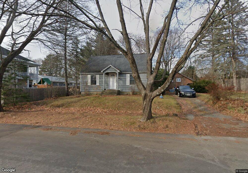
10 Harmon Rd Portland, ME 04102
Nasons Corner NeighborhoodEstimated Value: $405,190 - $485,000
3
Beds
1
Bath
1,134
Sq Ft
$390/Sq Ft
Est. Value
About This Home
This home is located at 10 Harmon Rd, Portland, ME 04102 and is currently estimated at $442,798, approximately $390 per square foot. 10 Harmon Rd is a home located in Cumberland County with nearby schools including Amanda C Rowe School, Lincoln Middle School, and Breakwater School.
Ownership History
Date
Name
Owned For
Owner Type
Purchase Details
Closed on
Feb 26, 2009
Sold by
Gordon Nathan H D and Gordon Shannon
Bought by
Graffius Benjamin W
Current Estimated Value
Home Financials for this Owner
Home Financials are based on the most recent Mortgage that was taken out on this home.
Original Mortgage
$260,000
Outstanding Balance
$162,756
Interest Rate
5%
Mortgage Type
Unknown
Estimated Equity
$280,042
Purchase Details
Closed on
Mar 28, 2005
Sold by
Gottlieb Heather M
Bought by
Thoits Jennifer
Home Financials for this Owner
Home Financials are based on the most recent Mortgage that was taken out on this home.
Original Mortgage
$168,800
Interest Rate
5.56%
Mortgage Type
Purchase Money Mortgage
Create a Home Valuation Report for This Property
The Home Valuation Report is an in-depth analysis detailing your home's value as well as a comparison with similar homes in the area
Home Values in the Area
Average Home Value in this Area
Purchase History
| Date | Buyer | Sale Price | Title Company |
|---|---|---|---|
| Graffius Benjamin W | -- | -- | |
| Thoits Jennifer | -- | -- |
Source: Public Records
Mortgage History
| Date | Status | Borrower | Loan Amount |
|---|---|---|---|
| Open | Graffius Benjamin W | $260,000 | |
| Previous Owner | Thoits Jennifer | $168,800 | |
| Previous Owner | Thoits Jennifer | $42,200 |
Source: Public Records
Tax History Compared to Growth
Tax History
| Year | Tax Paid | Tax Assessment Tax Assessment Total Assessment is a certain percentage of the fair market value that is determined by local assessors to be the total taxable value of land and additions on the property. | Land | Improvement |
|---|---|---|---|---|
| 2024 | $4,692 | $312,600 | $85,900 | $226,700 |
| 2023 | $4,505 | $312,600 | $85,900 | $226,700 |
| 2022 | $4,254 | $312,600 | $85,900 | $226,700 |
| 2021 | $4,061 | $312,600 | $85,900 | $226,700 |
| 2020 | $3,932 | $168,700 | $63,400 | $105,300 |
| 2019 | $3,932 | $168,700 | $63,400 | $105,300 |
| 2018 | $3,652 | $168,700 | $63,400 | $105,300 |
| 2017 | $3,652 | $168,700 | $63,400 | $105,300 |
| 2016 | $3,561 | $168,700 | $63,400 | $105,300 |
| 2015 | $3,480 | $168,700 | $63,400 | $105,300 |
| 2014 | $3,374 | $168,700 | $63,400 | $105,300 |
Source: Public Records
Map
Nearby Homes
- 0 Hillcrest Ave
- 63A Capisic St
- 99 Webb St
- 7 Dale Ct
- 159 Bancroft St
- 24 Celebration Ct Unit 13
- 37 Tremont St
- 18 Stoneledge Dr
- 4 Fairview St
- 147 Pleasant Ave Unit 2
- 1549 Westbrook St
- 1346 Westbrook St
- 97 Warren Ave
- 1542 Congress St
- 65 Mcauley Way Unit 506
- 75 Mcauley Way Unit 307
- 75 Mcauley Way Unit 206
- 75 Mcauley Way Unit 401
- 75 Mcauley Way Unit 207
- 75 Mcauley Way Unit 502