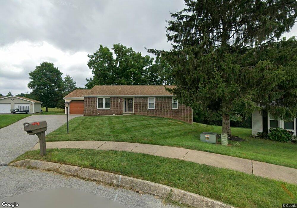
10 Harmony Ct Stewartstown, PA 17363
Estimated Value: $338,524 - $413,000
3
Beds
2
Baths
2,001
Sq Ft
$181/Sq Ft
Est. Value
About This Home
This home is located at 10 Harmony Ct, Stewartstown, PA 17363 and is currently estimated at $361,631, approximately $180 per square foot. 10 Harmony Ct is a home located in York County with nearby schools including South Eastern Intermediate School, South Eastern Middle School, and Kennard-Dale High School.
Ownership History
Date
Name
Owned For
Owner Type
Purchase Details
Closed on
Feb 20, 2018
Sold by
Cave Thomas E and Smith Rose A
Bought by
Smith Rose Anne
Current Estimated Value
Purchase Details
Closed on
Dec 18, 2007
Sold by
Cave Thomas E and Cave Thomas E
Bought by
Smith Rose A and Cave Thomas E
Home Financials for this Owner
Home Financials are based on the most recent Mortgage that was taken out on this home.
Original Mortgage
$126,700
Outstanding Balance
$80,196
Interest Rate
6.3%
Mortgage Type
New Conventional
Estimated Equity
$281,435
Purchase Details
Closed on
Jun 16, 1989
Bought by
Cave Thomas E
Create a Home Valuation Report for This Property
The Home Valuation Report is an in-depth analysis detailing your home's value as well as a comparison with similar homes in the area
Home Values in the Area
Average Home Value in this Area
Purchase History
| Date | Buyer | Sale Price | Title Company |
|---|---|---|---|
| Smith Rose Anne | -- | None Available | |
| Smith Rose A | -- | None Available | |
| Cave Thomas E | -- | -- |
Source: Public Records
Mortgage History
| Date | Status | Borrower | Loan Amount |
|---|---|---|---|
| Open | Smith Rose A | $126,700 |
Source: Public Records
Tax History Compared to Growth
Tax History
| Year | Tax Paid | Tax Assessment Tax Assessment Total Assessment is a certain percentage of the fair market value that is determined by local assessors to be the total taxable value of land and additions on the property. | Land | Improvement |
|---|---|---|---|---|
| 2025 | $4,325 | $147,320 | $43,700 | $103,620 |
| 2024 | $4,325 | $147,320 | $43,700 | $103,620 |
| 2023 | $4,325 | $147,320 | $43,700 | $103,620 |
| 2022 | $4,325 | $147,320 | $43,700 | $103,620 |
| 2021 | $4,178 | $147,320 | $43,700 | $103,620 |
| 2020 | $4,178 | $147,320 | $43,700 | $103,620 |
| 2019 | $4,163 | $147,320 | $43,700 | $103,620 |
| 2018 | $4,163 | $147,320 | $43,700 | $103,620 |
| 2017 | $4,163 | $147,320 | $43,700 | $103,620 |
| 2016 | $0 | $147,320 | $43,700 | $103,620 |
| 2015 | -- | $147,320 | $43,700 | $103,620 |
| 2014 | -- | $147,320 | $43,700 | $103,620 |
Source: Public Records
Map
Nearby Homes
- 17 Charles Ave
- 10 Black Oak Ct
- 150 Patterson Dr Unit 47
- 160 Patterson Dr Unit 48
- 180 Patterson Dr Unit 50
- 103 Hershey Cir
- 13 Baneberry St
- 82 Piston Ct
- 231 Cool Spring Ln
- 18007 Dave Anne Cir
- 94 Piston Ct
- 18010 Dave Anne Cir
- 9 W Pennsylvania Ave
- 2 S Main St
- 4341 Forbes Dr
- 4303 Forbes Dr
- 18183 Piedmont Rd
- 0 Five Forks Rd Unit PAYK2095070
- 0 Five Forks Rd Unit PAYK2095050
- 4389 Hess Rd
- 8 Harmony Ct
- 6 Harmony Ct
- Lot #6 Ryan Ln
- 14 Harmony Ct
- 4 Harmony Ct
- 16 Harmony Ct
- 2 Harmony Ct
- 6 Scarborough Fare
- lot 9 Barwood Ln Ln
- 8 Scarborough Fare
- 15 Springwood Ave
- 4 Scarborough Fare
- 11 Springwood Ave
- 11807 Pomraning Rd
- LOTS Orchard Rd
- 10 Scarborough Fare
- 12 Scarborough Fare
- 17 Springwood Ave
- 2 Scarborough Fare