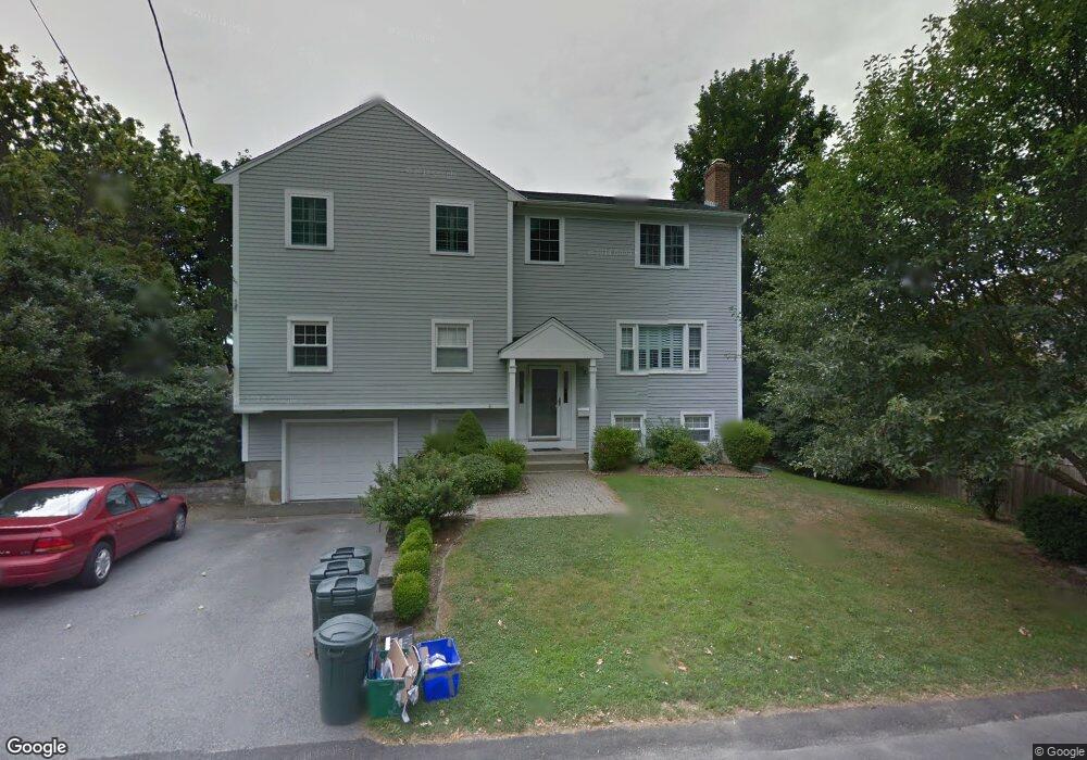
10 Hazard St Newport, RI 02840
Eustis-Easton's Pond NeighborhoodEstimated Value: $972,000 - $1,381,071
4
Beds
2
Baths
1,124
Sq Ft
$1,039/Sq Ft
Est. Value
About This Home
This home is located at 10 Hazard St, Newport, RI 02840 and is currently estimated at $1,167,768, approximately $1,038 per square foot. 10 Hazard St is a home located in Newport County with nearby schools including Rogers High School, St Michael's Country Day School, and All Saints STEAM Academy.
Ownership History
Date
Name
Owned For
Owner Type
Purchase Details
Closed on
Oct 17, 2019
Sold by
Turner Coleen K
Bought by
Turner Coleen K and Turner Mark
Current Estimated Value
Home Financials for this Owner
Home Financials are based on the most recent Mortgage that was taken out on this home.
Original Mortgage
$429,700
Outstanding Balance
$376,338
Interest Rate
3.7%
Mortgage Type
New Conventional
Estimated Equity
$791,430
Purchase Details
Closed on
Jul 2, 1999
Sold by
Borgueta Shirley A
Bought by
Hermes Thomas E and Hermes Colleen
Purchase Details
Closed on
Aug 16, 1988
Sold by
Henning Nancy
Bought by
Borgueta Shirley
Create a Home Valuation Report for This Property
The Home Valuation Report is an in-depth analysis detailing your home's value as well as a comparison with similar homes in the area
Home Values in the Area
Average Home Value in this Area
Purchase History
| Date | Buyer | Sale Price | Title Company |
|---|---|---|---|
| Turner Coleen K | -- | -- | |
| Hermes Thomas E | $137,000 | -- | |
| Borgueta Shirley | $168,500 | -- | |
| Borgueta Shirley | $168,500 | -- |
Source: Public Records
Mortgage History
| Date | Status | Borrower | Loan Amount |
|---|---|---|---|
| Open | Turner Coleen K | $429,700 | |
| Previous Owner | Borgueta Shirley | $318,500 | |
| Previous Owner | Borgueta Shirley | $100,000 |
Source: Public Records
Tax History Compared to Growth
Tax History
| Year | Tax Paid | Tax Assessment Tax Assessment Total Assessment is a certain percentage of the fair market value that is determined by local assessors to be the total taxable value of land and additions on the property. | Land | Improvement |
|---|---|---|---|---|
| 2025 | $7,439 | $1,036,100 | $361,000 | $675,100 |
| 2024 | $7,222 | $1,036,100 | $361,000 | $675,100 |
| 2023 | $6,758 | $681,300 | $212,400 | $468,900 |
| 2022 | $6,547 | $681,300 | $212,400 | $468,900 |
| 2021 | $6,357 | $681,300 | $212,400 | $468,900 |
| 2020 | $5,499 | $534,900 | $185,300 | $349,600 |
| 2019 | $5,499 | $534,900 | $185,300 | $349,600 |
| 2018 | $5,344 | $534,900 | $185,300 | $349,600 |
| 2017 | $5,368 | $478,900 | $142,600 | $336,300 |
| 2016 | $5,234 | $478,900 | $142,600 | $336,300 |
| 2015 | $5,110 | $478,900 | $142,600 | $336,300 |
| 2014 | $5,603 | $464,600 | $109,000 | $355,600 |
Source: Public Records
Map
Nearby Homes
- 5 Gardiner St
- 19 Princeton St Unit 21
- 198 Gibbs Ave
- 103 Champlin Place N
- 1 Arnold Ave
- 36 Kay Blvd
- 17 Lincoln St
- 5 Elliot Place
- 4 Newport Ave Unit B2
- 78 Rhode Island Ave Unit 6
- 78 Rhode Island Ave Unit 8
- 128 Eustis Ave
- 1 Shangri-La Ln
- 78 Ellery Rd
- 155 Evarts St
- 8 Champlin St
- 129 Bliss Mine Rd
- 125 Van Zandt Ave Unit 307
- 55 Hunter Ave
- 53 Warner St