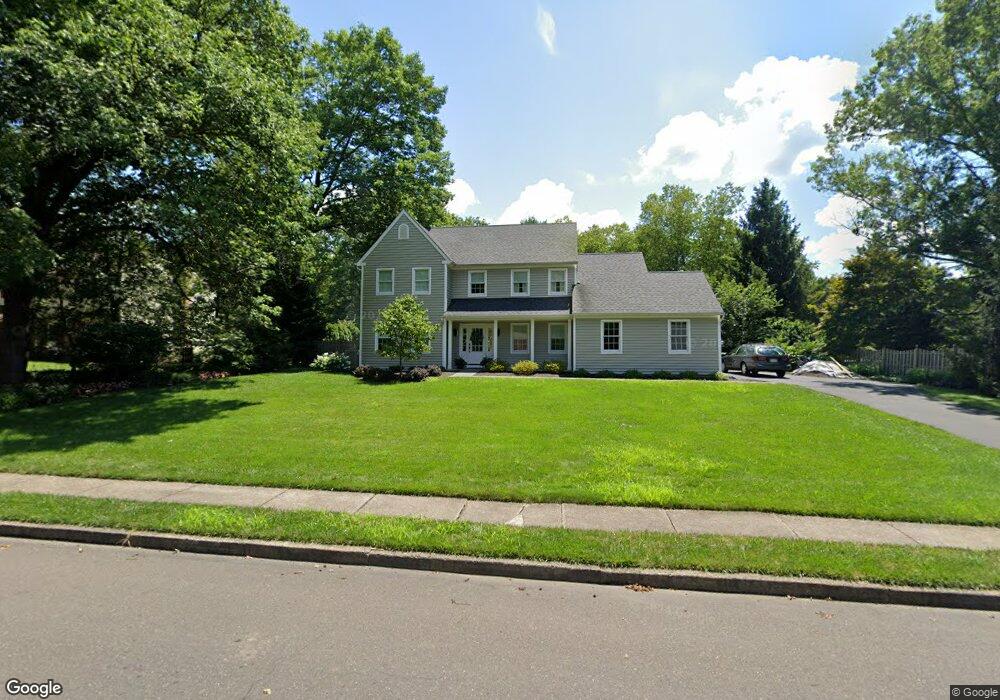
10 John Dyer Way Doylestown, PA 18902
Plumstead NeighborhoodEstimated Value: $783,949 - $874,000
4
Beds
3
Baths
2,638
Sq Ft
$315/Sq Ft
Est. Value
About This Home
This home is located at 10 John Dyer Way, Doylestown, PA 18902 and is currently estimated at $831,737, approximately $315 per square foot. 10 John Dyer Way is a home located in Bucks County with nearby schools including Gayman Elementary School, Tohickon Middle School, and Central Bucks High School - East.
Ownership History
Date
Name
Owned For
Owner Type
Purchase Details
Closed on
Aug 28, 2020
Sold by
Roig Anthony and Roig Lauren L
Bought by
Robinson Jonathan and Robinson Jennifer
Current Estimated Value
Home Financials for this Owner
Home Financials are based on the most recent Mortgage that was taken out on this home.
Original Mortgage
$503,040
Outstanding Balance
$447,235
Interest Rate
3%
Mortgage Type
New Conventional
Estimated Equity
$384,502
Purchase Details
Closed on
Dec 18, 1995
Sold by
Theesfeld Paul K and Theesfeld Gayle
Bought by
Roig Anthony and Roig Lauren L
Home Financials for this Owner
Home Financials are based on the most recent Mortgage that was taken out on this home.
Original Mortgage
$130,000
Interest Rate
6.99%
Purchase Details
Closed on
Mar 6, 1985
Bought by
Theesfeld Paul K and Theesfeld Gayle
Create a Home Valuation Report for This Property
The Home Valuation Report is an in-depth analysis detailing your home's value as well as a comparison with similar homes in the area
Home Values in the Area
Average Home Value in this Area
Purchase History
| Date | Buyer | Sale Price | Title Company |
|---|---|---|---|
| Robinson Jonathan | $628,800 | Foundation Abstract Llc | |
| Roig Anthony | $215,000 | -- | |
| Theesfeld Paul K | $118,300 | -- |
Source: Public Records
Mortgage History
| Date | Status | Borrower | Loan Amount |
|---|---|---|---|
| Open | Robinson Jonathan | $503,040 | |
| Previous Owner | Roig Anthony | $130,000 |
Source: Public Records
Tax History Compared to Growth
Tax History
| Year | Tax Paid | Tax Assessment Tax Assessment Total Assessment is a certain percentage of the fair market value that is determined by local assessors to be the total taxable value of land and additions on the property. | Land | Improvement |
|---|---|---|---|---|
| 2025 | $7,902 | $45,480 | $6,800 | $38,680 |
| 2024 | $7,902 | $45,480 | $6,800 | $38,680 |
| 2023 | $7,566 | $45,480 | $6,800 | $38,680 |
| 2022 | $7,566 | $45,480 | $6,800 | $38,680 |
| 2021 | $7,481 | $45,480 | $6,800 | $38,680 |
| 2020 | $7,481 | $45,480 | $6,800 | $38,680 |
| 2019 | $7,436 | $45,480 | $6,800 | $38,680 |
| 2018 | $7,436 | $45,480 | $6,800 | $38,680 |
| 2017 | $7,333 | $45,480 | $6,800 | $38,680 |
| 2016 | $7,333 | $45,480 | $6,800 | $38,680 |
| 2015 | -- | $45,480 | $6,800 | $38,680 |
| 2014 | -- | $45,480 | $6,800 | $38,680 |
Source: Public Records
Map
Nearby Homes
- 4190 Milords Ln
- 4221 Sir Andrew Cir
- 4330 Kleinot Dr
- 4263 Kleinot Dr
- 4317 Kleinot Dr
- 4306 Kleinot Dr
- 4464 Kleinot Dr
- 4246 Kleinot Dr
- 4298 Kleinot Dr
- 3923 Ferry Rd
- 4748 Bishop Cir
- 3838 Jacob Stout Rd
- 4605 Twinbrook Cir
- 3765 William Daves Rd
- 3723 William Daves Rd
- 3867 Charter Club Dr
- 3711 Jacob Stout Rd Unit 5
- 3600 Jacob Stout Rd Unit 3
- 114 Blackfriars Cir
- 100 Bishops Gate Ln Unit 67
- 9 John Dyer Way
- 11 John Dyer Way
- 12 John Dyer Way
- 8 John Dyer Way
- 41 John Dyer Way
- 42 John Dyer Way
- 13 John Dyer Way
- 40 John Dyer Way
- 43 John Dyer Way
- 53 John Dyer Way
- 7 John Dyer Way
- 39 John Dyer Way
- 44 John Dyer Way
- 14 John Dyer Way
- 38 John Dyer Way
- 45 John Dyer Way
- 68 John Dyer Way
- 6 John Dyer Way
- 4237 Landisville Rd
- 37 John Dyer Way