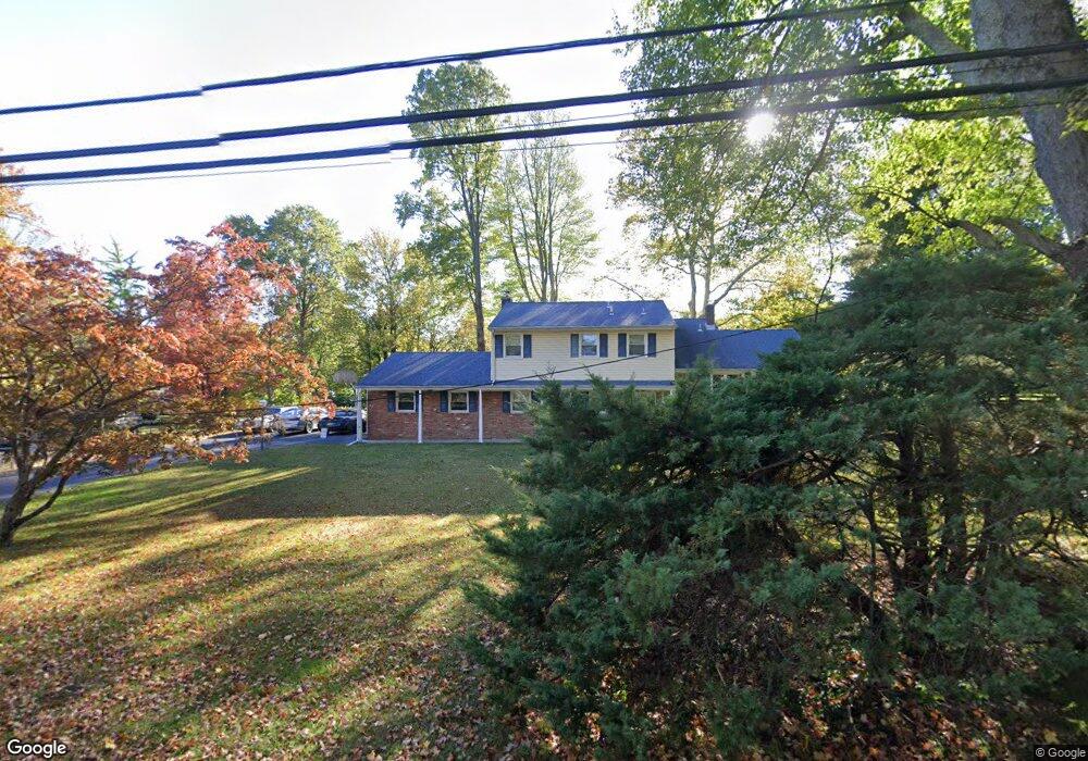
10 Kevin Rd Scotch Plains, NJ 07076
Estimated Value: $801,100 - $1,293,000
--
Bed
--
Bath
2,260
Sq Ft
$495/Sq Ft
Est. Value
About This Home
This home is located at 10 Kevin Rd, Scotch Plains, NJ 07076 and is currently estimated at $1,119,775, approximately $495 per square foot. 10 Kevin Rd is a home located in Union County with nearby schools including J. Ackerman Coles Elementary School, Terrill Middle School, and Scotch Plains-Fanwood High School.
Ownership History
Date
Name
Owned For
Owner Type
Purchase Details
Closed on
Jul 24, 2017
Sold by
Clarke Stephen and Clarke Rosemarie
Bought by
Clarke Stephen
Current Estimated Value
Purchase Details
Closed on
Aug 1, 2005
Sold by
Keeton David P
Bought by
Clarke Stephen and Clarke Rosemarie
Home Financials for this Owner
Home Financials are based on the most recent Mortgage that was taken out on this home.
Original Mortgage
$592,000
Outstanding Balance
$313,579
Interest Rate
5.79%
Mortgage Type
New Conventional
Estimated Equity
$806,196
Create a Home Valuation Report for This Property
The Home Valuation Report is an in-depth analysis detailing your home's value as well as a comparison with similar homes in the area
Home Values in the Area
Average Home Value in this Area
Purchase History
| Date | Buyer | Sale Price | Title Company |
|---|---|---|---|
| Clarke Stephen | -- | Chicago Title Ins Co | |
| Clarke Stephen | $740,000 | -- |
Source: Public Records
Mortgage History
| Date | Status | Borrower | Loan Amount |
|---|---|---|---|
| Open | Clarke Stephen | $592,000 |
Source: Public Records
Tax History Compared to Growth
Tax History
| Year | Tax Paid | Tax Assessment Tax Assessment Total Assessment is a certain percentage of the fair market value that is determined by local assessors to be the total taxable value of land and additions on the property. | Land | Improvement |
|---|---|---|---|---|
| 2025 | $18,805 | $159,800 | $62,500 | $97,300 |
| 2024 | $18,251 | $159,800 | $62,500 | $97,300 |
| 2023 | $18,251 | $159,800 | $62,500 | $97,300 |
| 2022 | $18,033 | $159,800 | $62,500 | $97,300 |
| 2021 | $18,003 | $159,800 | $62,500 | $97,300 |
| 2020 | $17,917 | $159,800 | $62,500 | $97,300 |
| 2019 | $17,784 | $159,800 | $62,500 | $97,300 |
| 2018 | $17,485 | $159,800 | $62,500 | $97,300 |
| 2017 | $17,097 | $159,800 | $62,500 | $97,300 |
| 2016 | $16,768 | $159,800 | $62,500 | $97,300 |
| 2015 | $16,493 | $159,800 | $62,500 | $97,300 |
| 2014 | $15,950 | $159,800 | $62,500 | $97,300 |
Source: Public Records
Map
Nearby Homes
- 939-45 Post Dr
- 19 Highlander Dr
- 1224 Sunnyfield Ln
- 1232 Sunnyfield Ln
- 32 Gere Place
- 1380 Terrill Rd
- 1158 Woodmere Place
- 848 Adam Cir
- 43 Cray Terrace
- 49 Highlander Dr
- 965 Hilltop Rd
- 481 Terrill Rd
- 6 Robin Rd
- 810 Leland Ave Unit 14
- 187 King St
- 5 Robin Rd
- 842 Berkeley Ave
- 15 La Grande Ave
- 1009 Mayfair Way
- 4 Brandywine Ct