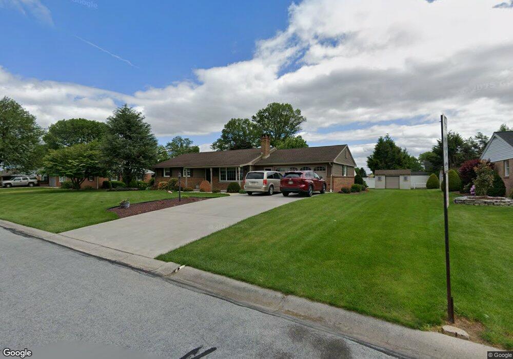
10 Lantern Ave Myerstown, PA 17067
Jackson NeighborhoodEstimated Value: $332,000 - $352,000
3
Beds
2
Baths
1,845
Sq Ft
$184/Sq Ft
Est. Value
About This Home
This home is located at 10 Lantern Ave, Myerstown, PA 17067 and is currently estimated at $340,390, approximately $184 per square foot. 10 Lantern Ave is a home located in Lebanon County with nearby schools including Eastern Lebanon County Senior High School, County Line School, and Myerstown Mennonite School.
Ownership History
Date
Name
Owned For
Owner Type
Purchase Details
Closed on
Mar 14, 2016
Sold by
Moyer Nancy A and Moyer Sheldon A
Bought by
Spangler Barry L and Spangler Jane L
Current Estimated Value
Purchase Details
Closed on
Aug 5, 2005
Sold by
Detweiler Lloyd K and Detweiler Bessie O
Bought by
Moyer Nancy A
Home Financials for this Owner
Home Financials are based on the most recent Mortgage that was taken out on this home.
Original Mortgage
$125,240
Interest Rate
5.54%
Mortgage Type
Purchase Money Mortgage
Create a Home Valuation Report for This Property
The Home Valuation Report is an in-depth analysis detailing your home's value as well as a comparison with similar homes in the area
Home Values in the Area
Average Home Value in this Area
Purchase History
| Date | Buyer | Sale Price | Title Company |
|---|---|---|---|
| Spangler Barry L | $160,000 | Attorney | |
| Moyer Nancy A | $155,000 | None Available |
Source: Public Records
Mortgage History
| Date | Status | Borrower | Loan Amount |
|---|---|---|---|
| Previous Owner | Moyer Nancy A | $125,240 |
Source: Public Records
Tax History Compared to Growth
Tax History
| Year | Tax Paid | Tax Assessment Tax Assessment Total Assessment is a certain percentage of the fair market value that is determined by local assessors to be the total taxable value of land and additions on the property. | Land | Improvement |
|---|---|---|---|---|
| 2025 | $4,373 | $193,400 | $38,700 | $154,700 |
| 2024 | $4,029 | $193,400 | $38,700 | $154,700 |
| 2023 | $4,006 | $192,300 | $38,700 | $153,600 |
| 2022 | $3,913 | $192,300 | $38,700 | $153,600 |
| 2021 | $3,728 | $192,300 | $38,700 | $153,600 |
| 2020 | $3,676 | $192,300 | $38,700 | $153,600 |
| 2019 | $3,603 | $192,300 | $38,700 | $153,600 |
| 2018 | $3,538 | $192,300 | $38,700 | $153,600 |
| 2017 | $633 | $192,300 | $38,700 | $153,600 |
| 2016 | $3,381 | $192,300 | $38,700 | $153,600 |
| 2015 | -- | $192,300 | $38,700 | $153,600 |
| 2014 | -- | $192,300 | $38,700 | $153,600 |
Source: Public Records
Map
Nearby Homes
- 544 N College St
- 651 W Lincoln Ave
- 116 W Washington Ave
- 608 E Lincoln Ave
- 212 E Main Ave
- 312 W Main Ave
- 106 Gable Dr
- 446 Stracks Dam Rd
- 79 Gable Dr
- 13 E Maple Ave
- 317 S Broad St
- 324 S Broad St
- 505 Stracks Dam Rd
- 14 Firefly Dr
- 409 E Rosebud Rd
- 147 Oaken Way
- 31 Laurel Dr
- 39 Laurel Dr
- 1300 E Kercher Ave Unit 32
- 1300 E Kercher Ave