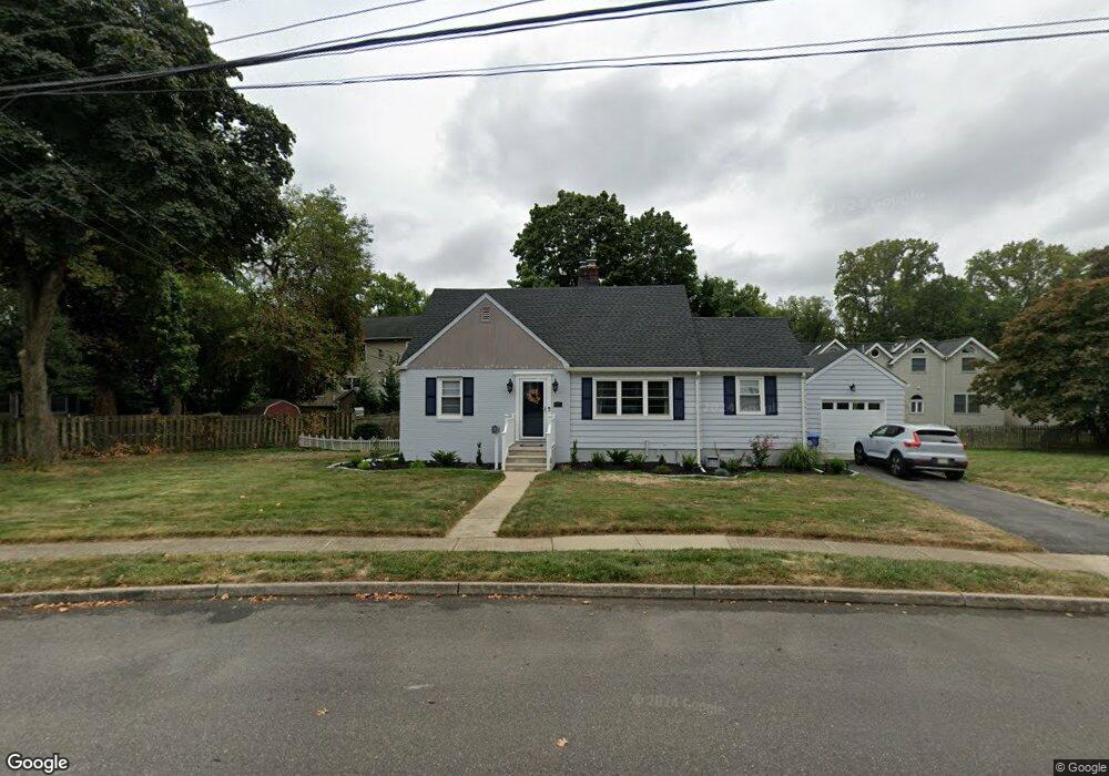
10 Lincoln Cir W Red Bank, NJ 07701
New Monmouth NeighborhoodEstimated Value: $648,000 - $760,865
3
Beds
2
Baths
1,668
Sq Ft
$432/Sq Ft
Est. Value
About This Home
This home is located at 10 Lincoln Cir W, Red Bank, NJ 07701 and is currently estimated at $720,466, approximately $431 per square foot. 10 Lincoln Cir W is a home located in Monmouth County with nearby schools including River Plaza Elementary School, Thompson Middle School, and Middletown - South High School.
Ownership History
Date
Name
Owned For
Owner Type
Purchase Details
Closed on
May 5, 2021
Sold by
Lesslie Lola
Bought by
Natale Melissa T and Natale Christopher S
Current Estimated Value
Home Financials for this Owner
Home Financials are based on the most recent Mortgage that was taken out on this home.
Original Mortgage
$335,000
Interest Rate
2.93%
Mortgage Type
New Conventional
Purchase Details
Closed on
Jul 30, 2013
Sold by
Estate Of Frnak J Piney and Scheier Catherine A
Bought by
Lesslie George and Lesslie Lola
Home Financials for this Owner
Home Financials are based on the most recent Mortgage that was taken out on this home.
Original Mortgage
$260,000
Interest Rate
4.31%
Mortgage Type
New Conventional
Create a Home Valuation Report for This Property
The Home Valuation Report is an in-depth analysis detailing your home's value as well as a comparison with similar homes in the area
Home Values in the Area
Average Home Value in this Area
Purchase History
| Date | Buyer | Sale Price | Title Company |
|---|---|---|---|
| Natale Melissa T | $420,000 | Signature Setmnt Svcs Agcy L | |
| Lesslie George | $350,000 | Agent For Old Republic Natio |
Source: Public Records
Mortgage History
| Date | Status | Borrower | Loan Amount |
|---|---|---|---|
| Previous Owner | Natale Melissa T | $335,000 | |
| Previous Owner | Lesslie George | $260,000 |
Source: Public Records
Tax History Compared to Growth
Tax History
| Year | Tax Paid | Tax Assessment Tax Assessment Total Assessment is a certain percentage of the fair market value that is determined by local assessors to be the total taxable value of land and additions on the property. | Land | Improvement |
|---|---|---|---|---|
| 2025 | $10,403 | $711,500 | $490,000 | $221,500 |
| 2024 | $10,200 | $632,400 | $415,000 | $217,400 |
| 2023 | $10,200 | $586,900 | $418,500 | $168,400 |
| 2022 | $8,443 | $491,200 | $335,000 | $156,200 |
| 2021 | $8,443 | $405,900 | $267,000 | $138,900 |
| 2020 | $7,928 | $370,800 | $235,000 | $135,800 |
| 2019 | $7,814 | $370,000 | $235,000 | $135,000 |
| 2018 | $7,881 | $363,700 | $235,000 | $128,700 |
| 2017 | $7,548 | $344,800 | $220,000 | $124,800 |
| 2016 | $7,454 | $349,800 | $220,000 | $129,800 |
| 2015 | $7,548 | $342,000 | $220,000 | $122,000 |
| 2014 | $7,049 | $311,500 | $200,000 | $111,500 |
Source: Public Records
Map
Nearby Homes
- 79 Lake Shore Dr
- 8 Cherry St
- 67 Victoria Place
- 390 Conover Place
- 398 Conover Place
- 130 Bodman Place Unit 15
- 130 Bodman Place Unit 8
- 928 Park Place
- 233 Conover Ln
- 833 Lincoln St
- 839 Arthur Dr
- 28 Riverside Ave Unit 2G
- 28 Riverside Ave Unit 4g
- 28 Riverside Ave Unit 10h
- 28 Riverside Ave Unit 1G
- 13 Applegate St
- 126 Manchester Ct
- 19 Manchester Ct
- 44 Monroe St
- 11 Manchester Ct
- 67 Lake Shore Dr
- 73 Lake Shore Dr
- 4 Lincoln Place
- 20 Lincoln Cir W
- 17 Lincoln Cir W
- 43 Lake Shore Dr
- 70 Lake Shore Dr
- 5 Lincoln Cir E
- 5 Lincoln Cir E
- 28 Lincoln Cir W
- 12 Lincoln Cir E
- 3 Lincoln Place
- 66 Lake Shore Dr
- 20 Lincoln Cir E
- 60 Lake Shore Dr
- 87 Lake Shore Dr
- 29 Lake Shore Dr
- 27 Lincoln Cir W
- 74 Lake Shore Dr
- 56 Lake Shore Dr