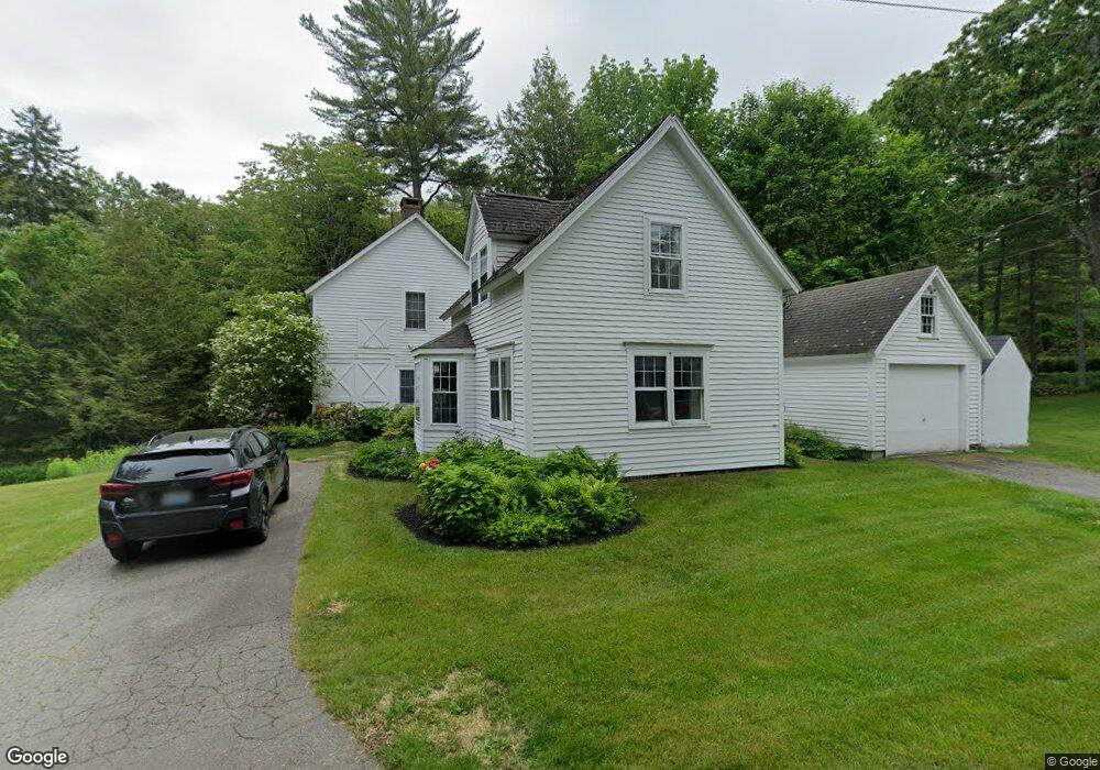
10 Maple St Rockport, ME 04856
Estimated Value: $638,000 - $871,000
3
Beds
3
Baths
2,007
Sq Ft
$396/Sq Ft
Est. Value
About This Home
This home is located at 10 Maple St, Rockport, ME 04856 and is currently estimated at $794,953, approximately $396 per square foot. 10 Maple St is a home located in Knox County with nearby schools including Camden-Rockport Elementary School, Camden-Rockport Middle School, and Camden Hills Regional High School.
Ownership History
Date
Name
Owned For
Owner Type
Purchase Details
Closed on
Aug 20, 2008
Sold by
Jefferis Donald R and Jefferis Michelle B
Bought by
Hartzell Kenneth J and Debrine Peter S
Current Estimated Value
Home Financials for this Owner
Home Financials are based on the most recent Mortgage that was taken out on this home.
Original Mortgage
$481,500
Outstanding Balance
$315,785
Interest Rate
6.4%
Mortgage Type
Unknown
Estimated Equity
$479,168
Create a Home Valuation Report for This Property
The Home Valuation Report is an in-depth analysis detailing your home's value as well as a comparison with similar homes in the area
Home Values in the Area
Average Home Value in this Area
Purchase History
| Date | Buyer | Sale Price | Title Company |
|---|---|---|---|
| Hartzell Kenneth J | -- | -- |
Source: Public Records
Mortgage History
| Date | Status | Borrower | Loan Amount |
|---|---|---|---|
| Open | Hartzell Kenneth J | $481,500 |
Source: Public Records
Tax History
| Year | Tax Paid | Tax Assessment Tax Assessment Total Assessment is a certain percentage of the fair market value that is determined by local assessors to be the total taxable value of land and additions on the property. | Land | Improvement |
|---|---|---|---|---|
| 2024 | $9,379 | $658,200 | $313,100 | $345,100 |
| 2023 | $8,326 | $658,200 | $313,100 | $345,100 |
| 2022 | $7,442 | $481,700 | $243,400 | $238,300 |
| 2021 | $7,596 | $445,500 | $268,600 | $176,900 |
| 2020 | $7,489 | $445,500 | $268,600 | $176,900 |
| 2019 | $7,596 | $445,500 | $268,600 | $176,900 |
| 2018 | $7,164 | $445,500 | $268,600 | $176,900 |
| 2017 | $6,571 | $445,500 | $268,600 | $176,900 |
| 2016 | $6,509 | $445,500 | $268,600 | $176,900 |
| 2015 | $6,259 | $445,500 | $268,600 | $176,900 |
| 2014 | $5,984 | $460,700 | $277,800 | $182,900 |
| 2013 | $5,846 | $460,700 | $277,800 | $182,900 |
Source: Public Records
Map
Nearby Homes
- 48 Sea St
- 360 Commercial St
- 1 Ship St
- 8 Ship St
- 26 Old Nutt Farm Rd
- 10 Summer St Unit 7
- 6 Summer St
- 80 Hayfield Way
- 3 Sea Light Ln
- 9 Rockport Woods
- 200 Mistic Ave
- Lot #19 Greenfield Dr
- Lot #23 Greenfield Dr
- 36 Roxmont Rd
- 17 John St
- 34 Curtis Ave
- Lot 2 Roxmont Rd
- Lot 1 Roxmont Rd
- 12 Hilltop Dr Unit 12
- 15 Hilltop Dr Unit 15
Your Personal Tour Guide
Ask me questions while you tour the home.