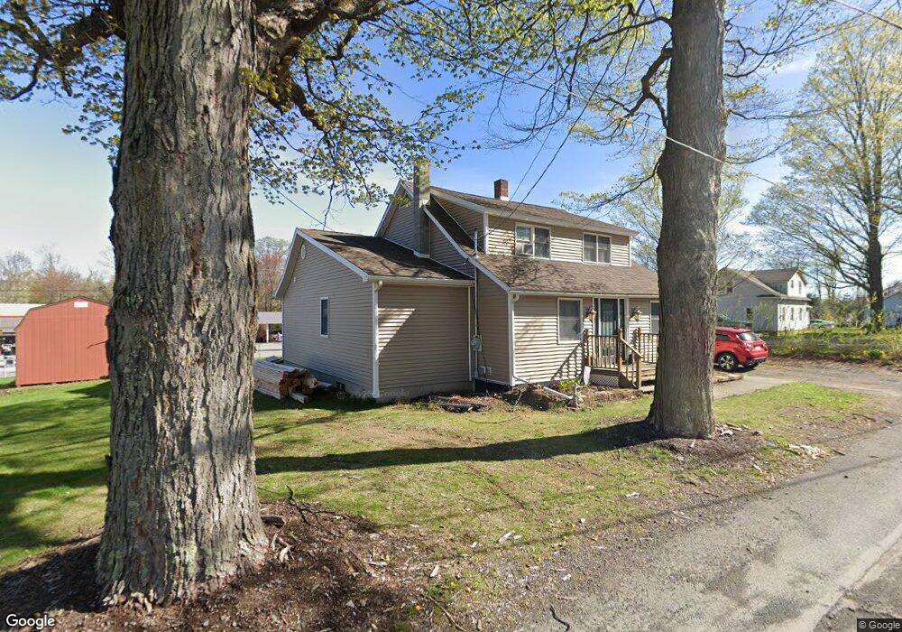
10 Maple St Waymart, PA 18472
Estimated Value: $189,000 - $277,320
3
Beds
3
Baths
1,243
Sq Ft
$194/Sq Ft
Est. Value
About This Home
This home is located at 10 Maple St, Waymart, PA 18472 and is currently estimated at $241,080, approximately $193 per square foot. 10 Maple St is a home located in Wayne County with nearby schools including Western Wayne High School.
Ownership History
Date
Name
Owned For
Owner Type
Purchase Details
Closed on
Sep 3, 2010
Sold by
Warnock John F and Warnock Susan M
Bought by
Warnock John F and Warnock Susan M
Current Estimated Value
Purchase Details
Closed on
Jun 27, 1983
Sold by
Farley Thomas J and Farley Mary A
Bought by
Warnock John F and Warnock Susan M
Home Financials for this Owner
Home Financials are based on the most recent Mortgage that was taken out on this home.
Original Mortgage
$30,000
Interest Rate
6.19%
Mortgage Type
New Conventional
Create a Home Valuation Report for This Property
The Home Valuation Report is an in-depth analysis detailing your home's value as well as a comparison with similar homes in the area
Home Values in the Area
Average Home Value in this Area
Purchase History
| Date | Buyer | Sale Price | Title Company |
|---|---|---|---|
| Warnock John F | -- | None Available | |
| Warnock John F | $30,000 | None Available |
Source: Public Records
Mortgage History
| Date | Status | Borrower | Loan Amount |
|---|---|---|---|
| Previous Owner | Warnock John F | $30,000 |
Source: Public Records
Tax History Compared to Growth
Tax History
| Year | Tax Paid | Tax Assessment Tax Assessment Total Assessment is a certain percentage of the fair market value that is determined by local assessors to be the total taxable value of land and additions on the property. | Land | Improvement |
|---|---|---|---|---|
| 2025 | $3,189 | $182,600 | $43,400 | $139,200 |
| 2024 | $3,043 | $182,600 | $43,400 | $139,200 |
| 2023 | $4,212 | $182,600 | $43,400 | $139,200 |
| 2022 | $2,693 | $105,100 | $19,000 | $86,100 |
| 2021 | $2,631 | $105,100 | $19,000 | $86,100 |
| 2020 | $2,604 | $105,100 | $19,000 | $86,100 |
| 2019 | $2,473 | $105,100 | $19,000 | $86,100 |
| 2018 | $2,460 | $105,100 | $19,000 | $86,100 |
| 2017 | $677 | $105,400 | $19,300 | $86,100 |
| 2016 | $2,396 | $105,400 | $19,300 | $86,100 |
| 2014 | -- | $105,400 | $19,300 | $86,100 |
Source: Public Records
Map
Nearby Homes
- 0 US Highway 6
- 8 Sleepy Hollow Rd
- 153 South St
- 391 South St
- 310 Stanton Dr
- 13 Bucklands Ln
- 765 Elk Lake Dr
- 25 Old Gravity Rd
- 2669 Easton Turnpike
- 58 Salem View Dr
- 22 Salem View Dr
- 65 River St
- 27 Gillow Ln
- 157 Creek Dr
- 6 Silhouette Ln
- 121 Delaware St
- 708 Morse Ave
- 20 Oak Ln
- 430 Flat Rock Rd
- 429 Flat Rock Rd
- 638 Roosevelt Hwy
- 396 Belmont St
- 394 Belmont St
- 11 Maple St
- 15 Maple St
- 386 Belmont St
- 17 Maple St
- 0 Roosevelt Hwy Unit PM-68519
- 0 Roosevelt Hwy Unit PM-68781
- 0 Roosevelt Hwy Unit GSB192493
- 0 Roosevelt Hwy Unit GSB083242
- 0 Roosevelt Hwy Unit GSB192639
- Route 6 Roosevelt Hwy
- 0 Roosevelt Hwy
- 401 Belmont St
- 11 Evergreen St
- 19 Maple St
- 387 Belmont St
- 387 Belmont St
- 382 Belmont St