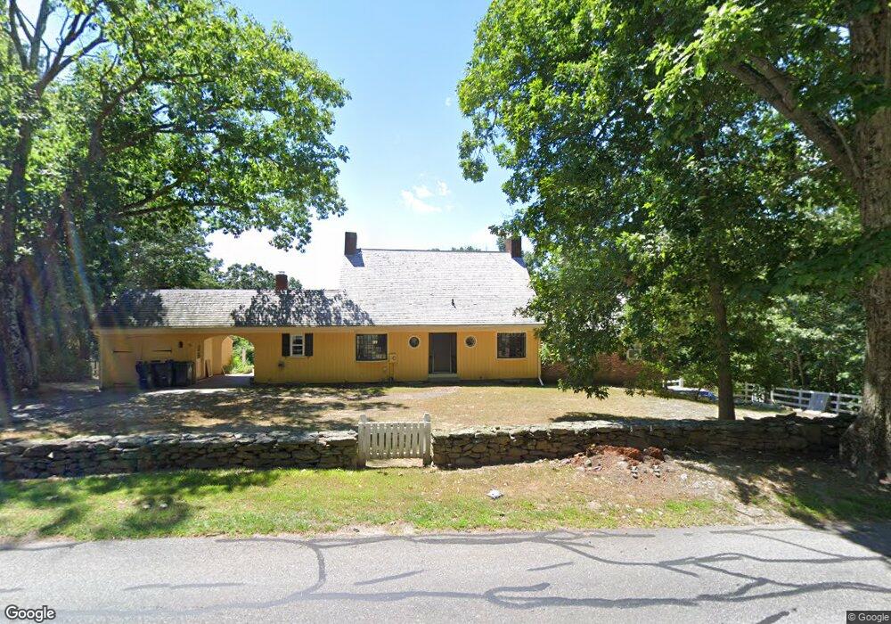
10 Mill Rd Westborough, MA 01581
Estimated Value: $652,000 - $772,000
4
Beds
3
Baths
2,203
Sq Ft
$329/Sq Ft
Est. Value
About This Home
This home is located at 10 Mill Rd, Westborough, MA 01581 and is currently estimated at $724,014, approximately $328 per square foot. 10 Mill Rd is a home located in Worcester County with nearby schools including Westborough High School, Ebridge Montessori School, and Westboro Knowledge Beginnings.
Ownership History
Date
Name
Owned For
Owner Type
Purchase Details
Closed on
Mar 21, 2022
Sold by
Mcguire Linda R
Bought by
Mcguire John
Current Estimated Value
Home Financials for this Owner
Home Financials are based on the most recent Mortgage that was taken out on this home.
Original Mortgage
$509,250
Outstanding Balance
$471,975
Interest Rate
3.55%
Mortgage Type
Purchase Money Mortgage
Estimated Equity
$252,039
Purchase Details
Closed on
Oct 21, 1980
Bought by
Mcguire James L
Create a Home Valuation Report for This Property
The Home Valuation Report is an in-depth analysis detailing your home's value as well as a comparison with similar homes in the area
Home Values in the Area
Average Home Value in this Area
Purchase History
| Date | Buyer | Sale Price | Title Company |
|---|---|---|---|
| Mcguire John | $525,000 | None Available | |
| Mcguire James L | $185,000 | -- |
Source: Public Records
Mortgage History
| Date | Status | Borrower | Loan Amount |
|---|---|---|---|
| Open | Mcguire John | $509,250 | |
| Previous Owner | Mcguire James L | $60,000 |
Source: Public Records
Tax History
| Year | Tax Paid | Tax Assessment Tax Assessment Total Assessment is a certain percentage of the fair market value that is determined by local assessors to be the total taxable value of land and additions on the property. | Land | Improvement |
|---|---|---|---|---|
| 2025 | $13,519 | $829,900 | $548,300 | $281,600 |
| 2024 | $12,951 | $789,200 | $530,900 | $258,300 |
| 2023 | $12,551 | $745,300 | $511,300 | $234,000 |
| 2022 | $12,362 | $668,600 | $452,500 | $216,100 |
| 2021 | $11,910 | $642,400 | $426,300 | $216,100 |
| 2020 | $11,688 | $638,000 | $421,900 | $216,100 |
| 2019 | $11,453 | $624,800 | $419,700 | $205,100 |
| 2018 | $10,921 | $591,600 | $411,000 | $180,600 |
| 2017 | $10,530 | $591,600 | $411,000 | $180,600 |
| 2016 | $10,221 | $575,200 | $404,500 | $170,700 |
| 2015 | $10,031 | $539,600 | $391,400 | $148,200 |
Source: Public Records
Map
Nearby Homes
- 192 W Main St
- 37 Oneil Dr
- 34 Harvey Ln
- 4203 Peters Farm Way Unit 4203
- 44 South St
- 22 Capt Samuel Forbush Rd
- 18 Fairview Rd
- 26 Mount Pleasant St
- 53 Robin Rd
- 7 Mayberry Dr Unit H
- 23 Water St
- 248 W Main St
- 155 Milk St Unit 27
- 155 Milk St Unit 5
- 1 Benjamin Dr
- 5 Wessonville Village Way Unit 5
- 196 -198 Turnpike Rd
- 49 Arch St Unit 1
- 7 Moses Wheelock Ln Unit 7
- 14 Baldwin Ct Unit 14
Your Personal Tour Guide
Ask me questions while you tour the home.