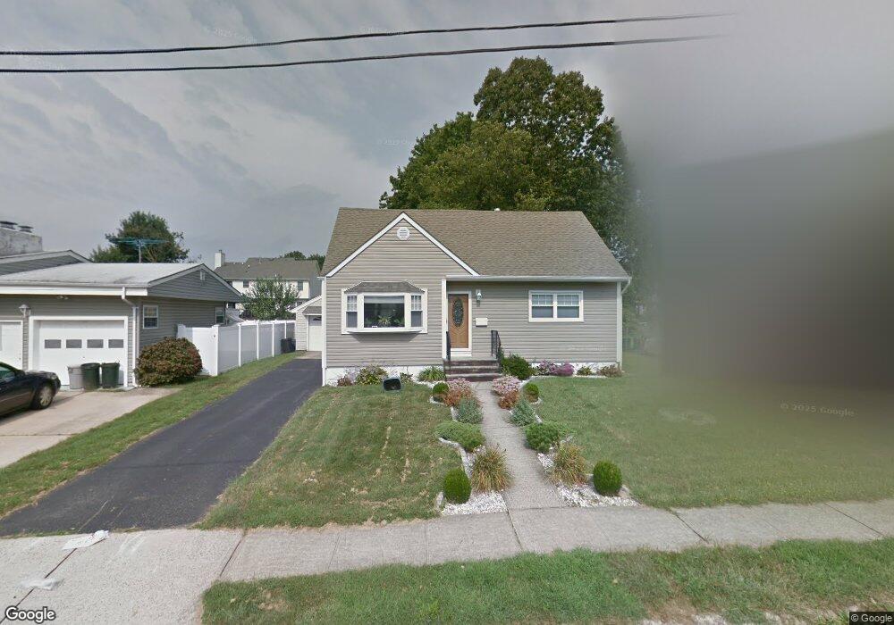
10 Mitchell Ave South River, NJ 08882
Estimated Value: $515,000 - $561,000
3
Beds
1
Bath
1,522
Sq Ft
$355/Sq Ft
Est. Value
About This Home
This home is located at 10 Mitchell Ave, South River, NJ 08882 and is currently estimated at $540,249, approximately $354 per square foot. 10 Mitchell Ave is a home located in Middlesex County with nearby schools including South River Primary School, South River Elementary School, and South River Middle School.
Ownership History
Date
Name
Owned For
Owner Type
Purchase Details
Closed on
Aug 23, 2016
Sold by
Pereira Antonio and Pereira Rosa
Bought by
Kamara Abu and Kallay Haja
Current Estimated Value
Home Financials for this Owner
Home Financials are based on the most recent Mortgage that was taken out on this home.
Original Mortgage
$295,000
Outstanding Balance
$234,995
Interest Rate
3.43%
Mortgage Type
New Conventional
Estimated Equity
$305,254
Purchase Details
Closed on
Dec 1, 2011
Sold by
Pereira Antonio and Pereira Rosa
Bought by
Pereira Antonio and Pereira Rosa
Purchase Details
Closed on
Dec 15, 2005
Sold by
Sikorskas Catherine
Bought by
Pereira Antonio and Pereira Rosa
Home Financials for this Owner
Home Financials are based on the most recent Mortgage that was taken out on this home.
Original Mortgage
$216,750
Interest Rate
6.24%
Mortgage Type
New Conventional
Create a Home Valuation Report for This Property
The Home Valuation Report is an in-depth analysis detailing your home's value as well as a comparison with similar homes in the area
Home Values in the Area
Average Home Value in this Area
Purchase History
| Date | Buyer | Sale Price | Title Company |
|---|---|---|---|
| Kamara Abu | $300,000 | Fidelity Nat Title Ins Co | |
| Pereira Antonio | -- | None Available | |
| Pereira Antonio | $289,000 | -- |
Source: Public Records
Mortgage History
| Date | Status | Borrower | Loan Amount |
|---|---|---|---|
| Open | Kamara Abu | $295,000 | |
| Previous Owner | Pereira Antonio | $216,750 |
Source: Public Records
Tax History Compared to Growth
Tax History
| Year | Tax Paid | Tax Assessment Tax Assessment Total Assessment is a certain percentage of the fair market value that is determined by local assessors to be the total taxable value of land and additions on the property. | Land | Improvement |
|---|---|---|---|---|
| 2025 | $7,458 | $292,800 | $149,200 | $143,600 |
| 2024 | $7,235 | $292,800 | $149,200 | $143,600 |
| 2023 | $7,235 | $292,800 | $149,200 | $143,600 |
| 2022 | $7,109 | $292,800 | $149,200 | $143,600 |
| 2021 | $4,788 | $292,800 | $149,200 | $143,600 |
| 2020 | $6,696 | $292,800 | $149,200 | $143,600 |
| 2019 | $6,532 | $79,300 | $23,300 | $56,000 |
| 2018 | $6,375 | $79,300 | $23,300 | $56,000 |
| 2017 | $6,142 | $79,300 | $23,300 | $56,000 |
| 2016 | $5,909 | $79,300 | $23,300 | $56,000 |
| 2015 | $5,777 | $79,300 | $23,300 | $56,000 |
| 2014 | $5,645 | $79,300 | $23,300 | $56,000 |
Source: Public Records
Map
Nearby Homes
- 68 Old Bridge Turnpike
- 19 Frandsen Ave
- 139 Old Bridge Turnpike
- 33 Gladstone Dr
- 147 Old Bridge Turnpike
- 67 Kamm Ave
- 20 Morningside Ave
- 11 Donna St
- 149 Prigmore St
- 40 Helena St
- 166 Joseph St
- 6 Donna St
- 13 Terry Ave
- 216 Willett Ave
- 29 Terry Ave
- 6 Terry Ln
- 212 Old Bridge Turnpike
- 17 Pearl Rd
- 28 Johnson Place
- 175 Willett Ave