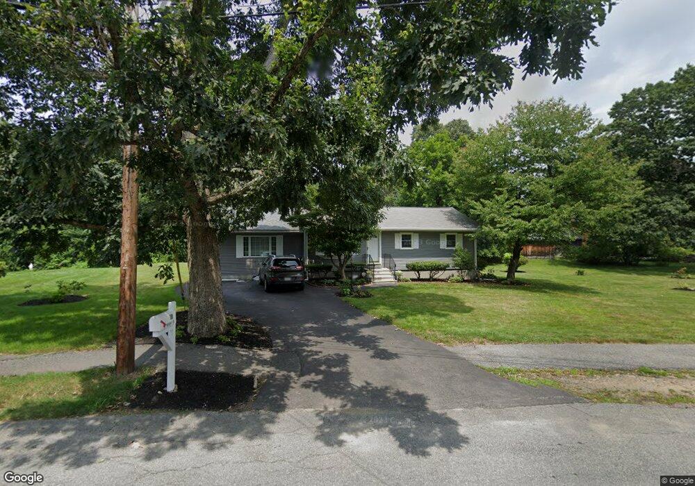
10 Mohawk Dr Northborough, MA 01532
Estimated Value: $540,000 - $628,000
3
Beds
2
Baths
912
Sq Ft
$633/Sq Ft
Est. Value
About This Home
This home is located at 10 Mohawk Dr, Northborough, MA 01532 and is currently estimated at $577,475, approximately $633 per square foot. 10 Mohawk Dr is a home located in Worcester County with nearby schools including Marion E. Zeh Elementary School, Robert E. Melican Middle School, and Algonquin Regional High School.
Ownership History
Date
Name
Owned For
Owner Type
Purchase Details
Closed on
May 27, 2008
Sold by
Lavner Barbara A and Lavner John W
Bought by
Yee Henry C and Yee Sandra P
Current Estimated Value
Home Financials for this Owner
Home Financials are based on the most recent Mortgage that was taken out on this home.
Original Mortgage
$255,300
Interest Rate
5.94%
Mortgage Type
Purchase Money Mortgage
Purchase Details
Closed on
Dec 8, 1989
Sold by
Mcgrath James
Bought by
Savner John
Create a Home Valuation Report for This Property
The Home Valuation Report is an in-depth analysis detailing your home's value as well as a comparison with similar homes in the area
Home Values in the Area
Average Home Value in this Area
Purchase History
| Date | Buyer | Sale Price | Title Company |
|---|---|---|---|
| Yee Henry C | $277,500 | -- | |
| Savner John | $120,000 | -- |
Source: Public Records
Mortgage History
| Date | Status | Borrower | Loan Amount |
|---|---|---|---|
| Open | Savner John | $259,999 | |
| Closed | Yee Henry C | $255,300 | |
| Previous Owner | Savner John | $150,000 | |
| Previous Owner | Savner John | $50,000 |
Source: Public Records
Tax History
| Year | Tax Paid | Tax Assessment Tax Assessment Total Assessment is a certain percentage of the fair market value that is determined by local assessors to be the total taxable value of land and additions on the property. | Land | Improvement |
|---|---|---|---|---|
| 2025 | $7,558 | $530,400 | $264,900 | $265,500 |
| 2024 | $6,706 | $469,600 | $219,600 | $250,000 |
| 2023 | $6,866 | $464,200 | $207,300 | $256,900 |
| 2022 | $6,649 | $403,200 | $197,300 | $205,900 |
| 2021 | $6,381 | $372,700 | $179,300 | $193,400 |
| 2020 | $6,407 | $371,400 | $179,300 | $192,100 |
| 2019 | $6,081 | $354,600 | $173,900 | $180,700 |
| 2018 | $5,659 | $325,400 | $168,100 | $157,300 |
| 2017 | $4,485 | $257,900 | $151,300 | $106,600 |
| 2016 | $4,342 | $252,900 | $148,300 | $104,600 |
| 2015 | $3,952 | $236,200 | $150,700 | $85,500 |
| 2014 | $3,821 | $230,300 | $150,700 | $79,600 |
Source: Public Records
Map
Nearby Homes
- 460 Whitney St
- 10 Sawyer Rd
- 245 Brewer St
- 429 Howard St
- 26 Treetop Cir
- 202 Brewer St
- 1A Mentzer Ave
- 122 Green St
- 125 Rice Ave
- 210 Green St
- 6 Silas Dr
- 243 Church St
- 85 Hudson St Unit 85
- 15 Dunia Ln Unit 15
- 13 Dennis Cir
- 39 Pleasant St Unit A6
- 39 Pleasant St Unit C5
- 39 Pleasant St Unit A17
- 39 Pleasant St Unit B10
- 39 Pleasant St Unit B4
- 14 Mohawk Dr
- 9 Mohawk Dr
- 119 Washburn St
- 18 Mohawk Dr
- 13 Mohawk Dr
- 111 Washburn St
- 123 Washburn St
- 17 Mohawk Dr
- 22 Mohawk Dr
- 16 Carriage Hill Rd
- 118 Washburn St
- 10 Carriage Hill Rd
- 127 Washburn St
- 5 Mohican Ave
- 21 Mohawk Dr
- 103 Washburn St
- 26 Mohawk Dr
- 122 Washburn St
- 6 Carriage Hill Rd
- 101 Washburn St
Your Personal Tour Guide
Ask me questions while you tour the home.