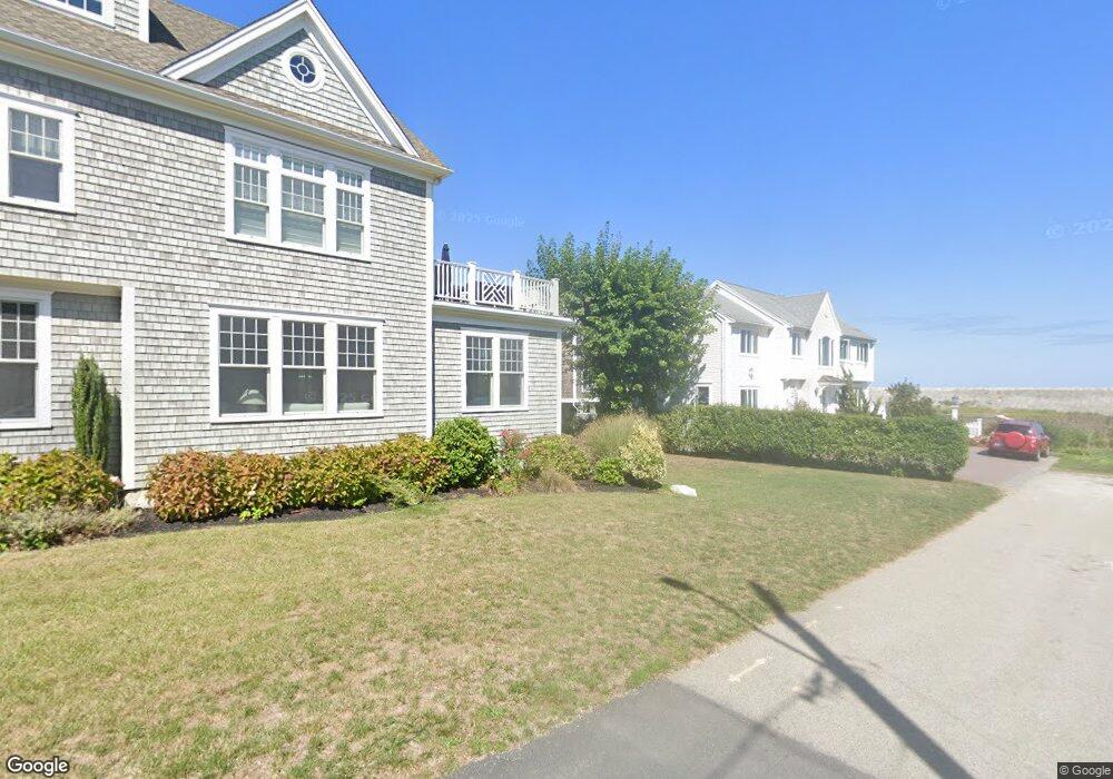
10 Montvale Ave Unit 10 Scituate, MA 02066
Estimated Value: $1,100,000 - $1,611,000
3
Beds
2
Baths
2,090
Sq Ft
$671/Sq Ft
Est. Value
About This Home
This home is located at 10 Montvale Ave Unit 10, Scituate, MA 02066 and is currently estimated at $1,401,615, approximately $670 per square foot. 10 Montvale Ave Unit 10 is a home located in Plymouth County with nearby schools including Wampatuck Elementary School, Lester J. Gates Middle School, and Scituate High School.
Ownership History
Date
Name
Owned For
Owner Type
Purchase Details
Closed on
Sep 20, 2021
Sold by
Bradlee Christopher
Bought by
Rojik Brian and Rojik Amy
Current Estimated Value
Home Financials for this Owner
Home Financials are based on the most recent Mortgage that was taken out on this home.
Original Mortgage
$881,100
Outstanding Balance
$800,539
Interest Rate
2.7%
Mortgage Type
Purchase Money Mortgage
Estimated Equity
$601,076
Purchase Details
Closed on
Jul 18, 2012
Sold by
Arai Maya
Bought by
Bradlee Christopher
Home Financials for this Owner
Home Financials are based on the most recent Mortgage that was taken out on this home.
Original Mortgage
$417,000
Interest Rate
3.7%
Mortgage Type
New Conventional
Purchase Details
Closed on
May 14, 2007
Sold by
Arai Maya and Peak David A
Bought by
Arai Maya
Purchase Details
Closed on
Feb 7, 2005
Sold by
Peak David and Arai Maya
Bought by
Peak David A and Arai Maya
Home Financials for this Owner
Home Financials are based on the most recent Mortgage that was taken out on this home.
Original Mortgage
$494,000
Interest Rate
5.77%
Mortgage Type
Purchase Money Mortgage
Purchase Details
Closed on
Aug 28, 2003
Sold by
Metcalf Darlene J
Bought by
Peak David A and Arai Maya
Home Financials for this Owner
Home Financials are based on the most recent Mortgage that was taken out on this home.
Original Mortgage
$322,700
Interest Rate
5.69%
Mortgage Type
Purchase Money Mortgage
Create a Home Valuation Report for This Property
The Home Valuation Report is an in-depth analysis detailing your home's value as well as a comparison with similar homes in the area
Home Values in the Area
Average Home Value in this Area
Purchase History
| Date | Buyer | Sale Price | Title Company |
|---|---|---|---|
| Rojik Brian | $979,000 | None Available | |
| Bradlee Christopher | $575,000 | -- | |
| Arai Maya | -- | -- | |
| Peak David A | -- | -- | |
| Peak David A | $525,000 | -- |
Source: Public Records
Mortgage History
| Date | Status | Borrower | Loan Amount |
|---|---|---|---|
| Open | Rojik Brian | $881,100 | |
| Previous Owner | Bradlee Christopher | $417,000 | |
| Previous Owner | Peak David A | $494,000 | |
| Previous Owner | Peak David A | $322,700 | |
| Previous Owner | Peak David A | $176,000 |
Source: Public Records
Tax History Compared to Growth
Tax History
| Year | Tax Paid | Tax Assessment Tax Assessment Total Assessment is a certain percentage of the fair market value that is determined by local assessors to be the total taxable value of land and additions on the property. | Land | Improvement |
|---|---|---|---|---|
| 2025 | $12,237 | $1,224,900 | $643,400 | $581,500 |
| 2024 | $12,027 | $1,160,900 | $584,900 | $576,000 |
| 2023 | $8,922 | $1,067,900 | $531,700 | $536,200 |
| 2022 | $8,922 | $707,000 | $427,700 | $279,300 |
| 2021 | $12,592 | $657,800 | $407,400 | $250,400 |
| 2020 | $8,548 | $633,200 | $391,600 | $241,600 |
| 2019 | $12,248 | $614,800 | $384,000 | $230,800 |
| 2018 | $8,017 | $574,700 | $360,100 | $214,600 |
| 2017 | $7,286 | $517,100 | $311,400 | $205,700 |
| 2016 | $7,175 | $507,400 | $301,700 | $205,700 |
| 2015 | $6,520 | $497,700 | $292,000 | $205,700 |
Source: Public Records
Map
Nearby Homes