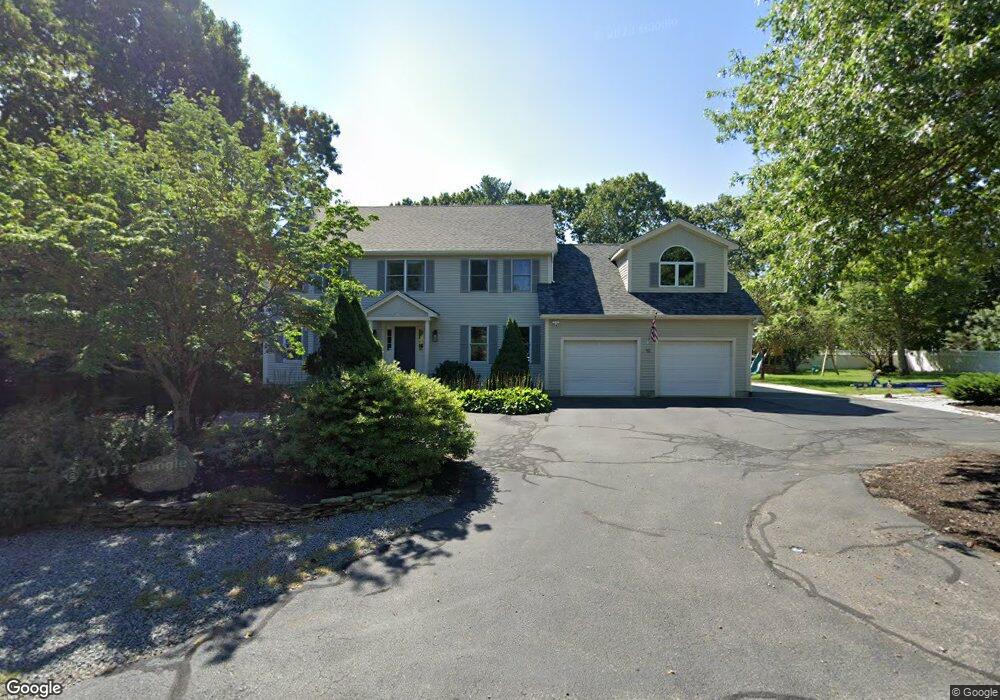
10 Oak Point Wrentham, MA 02093
Estimated Value: $879,000 - $1,158,000
4
Beds
3
Baths
3,850
Sq Ft
$265/Sq Ft
Est. Value
About This Home
This home is located at 10 Oak Point, Wrentham, MA 02093 and is currently estimated at $1,021,664, approximately $265 per square foot. 10 Oak Point is a home located in Norfolk County with nearby schools including Delaney Elementary School and Charles E Roderick.
Ownership History
Date
Name
Owned For
Owner Type
Purchase Details
Closed on
Aug 17, 2018
Sold by
Lincoln Ft
Bought by
Colvin Kelly V and Colvin Lynn
Current Estimated Value
Home Financials for this Owner
Home Financials are based on the most recent Mortgage that was taken out on this home.
Original Mortgage
$445,000
Outstanding Balance
$386,464
Interest Rate
4.5%
Mortgage Type
VA
Estimated Equity
$635,200
Purchase Details
Closed on
Mar 7, 1996
Sold by
Council Oaks Assoc Inc
Bought by
Lincoln Family Fund T
Purchase Details
Closed on
Feb 2, 1995
Sold by
Raymond Tr Bradley H and Raymond Tr Mary Alice
Bought by
Council Oaks Assoc Inc
Create a Home Valuation Report for This Property
The Home Valuation Report is an in-depth analysis detailing your home's value as well as a comparison with similar homes in the area
Purchase History
| Date | Buyer | Sale Price | Title Company |
|---|---|---|---|
| Colvin Kelly V | $575,000 | -- | |
| Lincoln Family Fund T | $316,305 | -- | |
| Council Oaks Assoc Inc | $110,000 | -- |
Source: Public Records
Mortgage History
| Date | Status | Borrower | Loan Amount |
|---|---|---|---|
| Open | Colvin Kelly V | $445,000 | |
| Previous Owner | Council Oaks Assoc Inc | $126,000 | |
| Previous Owner | Council Oaks Assoc Inc | $240,000 | |
| Previous Owner | Council Oaks Assoc Inc | $175,000 |
Source: Public Records
Tax History
| Year | Tax Paid | Tax Assessment Tax Assessment Total Assessment is a certain percentage of the fair market value that is determined by local assessors to be the total taxable value of land and additions on the property. | Land | Improvement |
|---|---|---|---|---|
| 2025 | $10,541 | $909,500 | $315,900 | $593,600 |
| 2024 | $10,148 | $845,700 | $315,900 | $529,800 |
| 2023 | $10,019 | $793,900 | $287,200 | $506,700 |
| 2022 | $9,443 | $690,800 | $246,600 | $444,200 |
| 2021 | $9,276 | $659,300 | $259,100 | $400,200 |
| 2020 | $8,982 | $630,300 | $183,400 | $446,900 |
| 2019 | $8,728 | $618,100 | $191,400 | $426,700 |
| 2018 | $8,309 | $583,500 | $187,800 | $395,700 |
| 2017 | $8,077 | $566,800 | $184,100 | $382,700 |
| 2016 | $7,974 | $558,400 | $178,800 | $379,600 |
| 2015 | $7,930 | $529,400 | $171,900 | $357,500 |
| 2014 | $7,862 | $513,500 | $165,300 | $348,200 |
Source: Public Records
Map
Nearby Homes
- 500 Franklin St
- 2 Earle Stewart Ln
- 12 Earle Stewart Ln
- 3 Earle Stewart Ln
- 10 Nature View Dr
- 15 Nature View Dr
- 10 Earle Stewart Ln Unit Lot 5
- 287 Park St
- 50 Reed Fulton Ave Unit Lot 61
- 45 Joshua Rd
- 246 Forest Grove Ave
- 75 Jordan Rd
- 3 Oak View Terrace Unit 3
- 9 Elliot Mills Unit 5
- 8 Elliot Mills Unit 30
- 5 Elliot Mills Unit 3
- 7 Elliot Mills Unit 4
- 10 Elliot Mills Unit 29
- 576 Dedham St
- 0 W Birch Rd
Your Personal Tour Guide
Ask me questions while you tour the home.