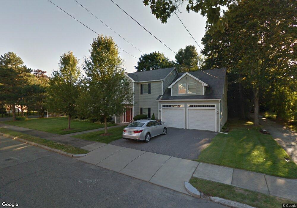
10 Orourke Path Newton Center, MA 02459
Mount Ida NeighborhoodEstimated Value: $1,028,000 - $1,460,000
4
Beds
2
Baths
1,936
Sq Ft
$632/Sq Ft
Est. Value
About This Home
This home is located at 10 Orourke Path, Newton Center, MA 02459 and is currently estimated at $1,222,937, approximately $631 per square foot. 10 Orourke Path is a home located in Middlesex County with nearby schools including Memorial Spaulding Elementary School, Oak Hill Middle School, and Newton South High School.
Ownership History
Date
Name
Owned For
Owner Type
Purchase Details
Closed on
Nov 17, 2025
Sold by
Fader Ira C and Saltz Emily B
Bought by
Garden Path Estates Llc
Current Estimated Value
Home Financials for this Owner
Home Financials are based on the most recent Mortgage that was taken out on this home.
Original Mortgage
$2,266,250
Outstanding Balance
$2,264,137
Interest Rate
6.34%
Mortgage Type
Purchase Money Mortgage
Estimated Equity
-$1,041,200
Purchase Details
Closed on
Jul 1, 1991
Sold by
Dercole Ft
Bought by
Fader Ira C and Saltz Emily B
Home Financials for this Owner
Home Financials are based on the most recent Mortgage that was taken out on this home.
Original Mortgage
$156,000
Interest Rate
9.44%
Mortgage Type
Purchase Money Mortgage
Create a Home Valuation Report for This Property
The Home Valuation Report is an in-depth analysis detailing your home's value as well as a comparison with similar homes in the area
Home Values in the Area
Average Home Value in this Area
Purchase History
| Date | Buyer | Sale Price | Title Company |
|---|---|---|---|
| Garden Path Estates Llc | $1,315,000 | -- | |
| Fader Ira C | $195,000 | -- |
Source: Public Records
Mortgage History
| Date | Status | Borrower | Loan Amount |
|---|---|---|---|
| Open | Garden Path Estates Llc | $2,266,250 | |
| Previous Owner | Fader Ira C | $44,500 | |
| Previous Owner | Fader Ira C | $160,000 | |
| Previous Owner | Fader Ira C | $160,000 | |
| Previous Owner | Fader Ira C | $156,000 |
Source: Public Records
Tax History
| Year | Tax Paid | Tax Assessment Tax Assessment Total Assessment is a certain percentage of the fair market value that is determined by local assessors to be the total taxable value of land and additions on the property. | Land | Improvement |
|---|---|---|---|---|
| 2025 | $7,723 | $788,100 | $664,500 | $123,600 |
| 2024 | $7,467 | $765,100 | $645,100 | $120,000 |
| 2023 | $6,823 | $670,200 | $490,900 | $179,300 |
| 2022 | $6,529 | $620,600 | $454,500 | $166,100 |
| 2021 | $6,300 | $585,500 | $428,800 | $156,700 |
| 2020 | $6,113 | $585,500 | $428,800 | $156,700 |
| 2019 | $5,940 | $568,400 | $416,300 | $152,100 |
| 2018 | $5,597 | $517,300 | $377,500 | $139,800 |
| 2017 | $5,427 | $488,000 | $356,100 | $131,900 |
| 2016 | $5,190 | $456,100 | $332,800 | $123,300 |
| 2015 | $4,949 | $426,300 | $311,000 | $115,300 |
Source: Public Records
Map
Nearby Homes
- 17 Caldon Path
- 90 Mccarthy Rd
- 30 K Roadway
- 25 Cavanaugh Path
- 544 Saw Mill Brook Pkwy
- 36 Ober Rd
- 21 Lovett Rd
- 210 Nahanton St Unit 404
- 50 Lovett Rd
- 28 Cottonwood Rd
- 577 Baker St Unit 577
- 931 Lagrange St
- 923 Lagrange St
- 150 Country Club Rd
- 845 Lagrange St Unit 4
- 135 Hartman Rd
- 17 Tirrell Crescent
- 93 Sevland Rd
- 63 Drumlin Rd
- 41 Juniper Ln
- 18 Orourke Path
- 56 Hanson Rd
- 9 Orourke Path
- 9 Orourke Path Unit 9
- 9 O'Rourke Path
- 24 O'Rourke Path
- 24 Orourke Path
- 17 Orourke Path
- 11 Caldon Path
- 44 Hanson Rd
- 44 Hanson Rd Unit 44
- 66 Hanson Rd
- 25 Orourke Path
- 25 O'Rourke Path
- 6 Caldon Path (Colella Rd)
- 55 Hanson Rd
- 51 Hanson Rd
- 32 Orourke Path T Rdwy
- 32 Orourke Path
- 25 Caldon Path