L
Seller's Agent in 2019
Lois Lengyel
Legacy Properties Sotheby's International Realty
(207) 233-2820
37 Total Sales


Estimated Value: $793,000 - $1,041,000
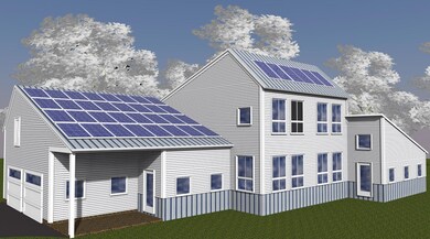
Be one of the first to build in this exciting new community of simply scaled & efficient living space homes w/all day sun exposure. Neighborhood is made up of 1 acre lots nestled among 13 acres of communal space. Building details include post & beam framing, electric heat pump for heating/cooling, exposed timbers, custom cabinets, hardwood & concrete floors. Solar package offsets 100% utility costs. Burnham & Lobozzo are exclusive builders.
Last Agent to Sell the Property
Legacy Properties Sotheby's International Realty Listed on: 01/25/2019

Last Buyer's Agent
NON-MREIS AGENT
Non MREIS Agency
| Date | Event | Price | List to Sale | Price per Sq Ft |
|---|---|---|---|---|
| 02/08/2019 02/08/19 | Sold | $95,000 | 0.0% | -- |
| 01/25/2019 01/25/19 | Pending | -- | -- | -- |
| 01/25/2019 01/25/19 | For Sale | $95,000 | -- | -- |
| Year | Tax Paid | Tax Assessment Tax Assessment Total Assessment is a certain percentage of the fair market value that is determined by local assessors to be the total taxable value of land and additions on the property. | Land | Improvement |
|---|---|---|---|---|
| 2025 | $9,725 | $702,200 | $217,900 | $484,300 |
| 2024 | $9,236 | $691,800 | $207,500 | $484,300 |
| 2023 | $8,422 | $612,500 | $188,600 | $423,900 |
| 2022 | $8,092 | $592,800 | $168,900 | $423,900 |
| 2021 | $7,620 | $570,800 | $168,900 | $401,900 |
| 2020 | $1,334 | $95,300 | $95,300 | $0 |
| 2019 | $1,286 | $89,900 | $89,900 | $0 |
L
Seller's Agent in 2019
Lois Lengyel
Legacy Properties Sotheby's International Realty
(207) 233-2820
37 Total Sales
N
Buyer's Agent in 2019
NON-MREIS AGENT
Non MREIS Agency
Source: Maine Listings
MLS Number: 1403072
APN: 17 76 6 0
Disclaimer: Certain information contained herein is derived from information provided by parties other than Homes.com. All information provided is deemed reliable, but is not guaranteed to be accurate and should be independently verified.
![]() Listing data is derived in whole or in part from Maine Real Estate Information System, Inc. (d/b/a Maine Listings) and is for consumers' personal, noncommercial use only. Dimensions are approximate and not guaranteed. All data should be independently verified.
Listing data is derived in whole or in part from Maine Real Estate Information System, Inc. (d/b/a Maine Listings) and is for consumers' personal, noncommercial use only. Dimensions are approximate and not guaranteed. All data should be independently verified.
© 2026 Maine Real Estate Information System, Inc. All Rights Reserved. Equal Housing Opportunity.
Homes.com, LLC, 17600 Laguna Canyon Rd Irvine, CA 92618 (888)-952-6393
![]()
Ask me questions while you tour the home.