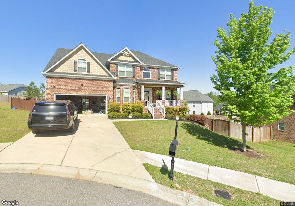
10 Pickard Ct Chapin, SC 29036
Estimated Value: $410,000 - $472,000
5
Beds
3
Baths
2,998
Sq Ft
$145/Sq Ft
Est. Value
About This Home
This home is located at 10 Pickard Ct, Chapin, SC 29036 and is currently estimated at $435,409, approximately $145 per square foot. 10 Pickard Ct is a home located in Richland County with nearby schools including Ballentine Elementary School, Chapin Intermediate, and Chapin High School.
Ownership History
Date
Name
Owned For
Owner Type
Purchase Details
Closed on
Mar 28, 2016
Sold by
D R Horton Crown Llc
Bought by
Rich Jonathan J and Rich Mary D
Current Estimated Value
Home Financials for this Owner
Home Financials are based on the most recent Mortgage that was taken out on this home.
Original Mortgage
$274,828
Outstanding Balance
$215,511
Interest Rate
3.62%
Mortgage Type
FHA
Estimated Equity
$219,898
Purchase Details
Closed on
May 8, 2014
Sold by
S C Pillon Homes Inc
Bought by
D R Horton Corwn Llc
Purchase Details
Closed on
Jun 5, 2013
Sold by
Broad River Developers Llc
Bought by
Sc Pillon Homes Inc
Create a Home Valuation Report for This Property
The Home Valuation Report is an in-depth analysis detailing your home's value as well as a comparison with similar homes in the area
Home Values in the Area
Average Home Value in this Area
Purchase History
| Date | Buyer | Sale Price | Title Company |
|---|---|---|---|
| Rich Jonathan J | $280,000 | None Available | |
| D R Horton Corwn Llc | $1,597,210 | None Available | |
| Sc Pillon Homes Inc | $682,500 | None Available |
Source: Public Records
Mortgage History
| Date | Status | Borrower | Loan Amount |
|---|---|---|---|
| Open | Rich Jonathan J | $274,828 |
Source: Public Records
Tax History
| Year | Tax Paid | Tax Assessment Tax Assessment Total Assessment is a certain percentage of the fair market value that is determined by local assessors to be the total taxable value of land and additions on the property. | Land | Improvement |
|---|---|---|---|---|
| 2024 | $2,521 | $295,900 | $0 | $0 |
| 2023 | $2,423 | $10,292 | $0 | $0 |
| 2022 | $2,099 | $257,300 | $48,000 | $209,300 |
| 2021 | $2,123 | $10,290 | $0 | $0 |
| 2020 | $2,222 | $10,290 | $0 | $0 |
| 2019 | $2,209 | $10,290 | $0 | $0 |
| 2018 | $2,112 | $11,200 | $0 | $0 |
| 2017 | $2,055 | $11,200 | $0 | $0 |
| 2016 | $6,433 | $14,580 | $0 | $0 |
| 2015 | $1,146 | $2,700 | $0 | $0 |
| 2014 | $1,101 | $45,000 | $0 | $0 |
| 2013 | -- | $2,700 | $0 | $0 |
Source: Public Records
Map
Nearby Homes
- 297 Massey Cir
- 301 Massey Cir
- 549 Everton Dr
- 321 Hollow Cove Rd
- 320 Hollow Cove Rd
- 445 Crawley Ln
- 426 Crawley Ln
- 420 Crawley Ln
- 649 Clover View Rd
- 11437 Broad River
- 668 Autumn Ridge Rd
- 205 Whitewater Dr
- 50 Steve Free Rd
- 101 Summer Branch Ln
- 133 Monroe Preserve Ln
- 114 Monroe Preserve Ln
- 145 Monroe Preserve Ln
- 105 Monroe Preserve Ln
- 117 Monroe Preserve Ln
- 110 Monroe Preserve Ln
- 12 Pickard Ct
- 571 Everton Dr
- 285 Massey Cir
- 271 Massey Cir
- 291 Massey Cir
- 11 Pickard Ct
- 293 Massey Cir
- 561 Everton Dr
- 249 Massey Cir
- 363 Massey Circle
- 262 Massey Cir
- 557 Everton Dr
- 258 Massey Cir
- 266 Massey Cir
- 556 Everton Dr
- 286 Massey Cir
- 282 Massey Cir
- 274 Massey Cir
- 278 Massey Cir
- 252 Massey Cir