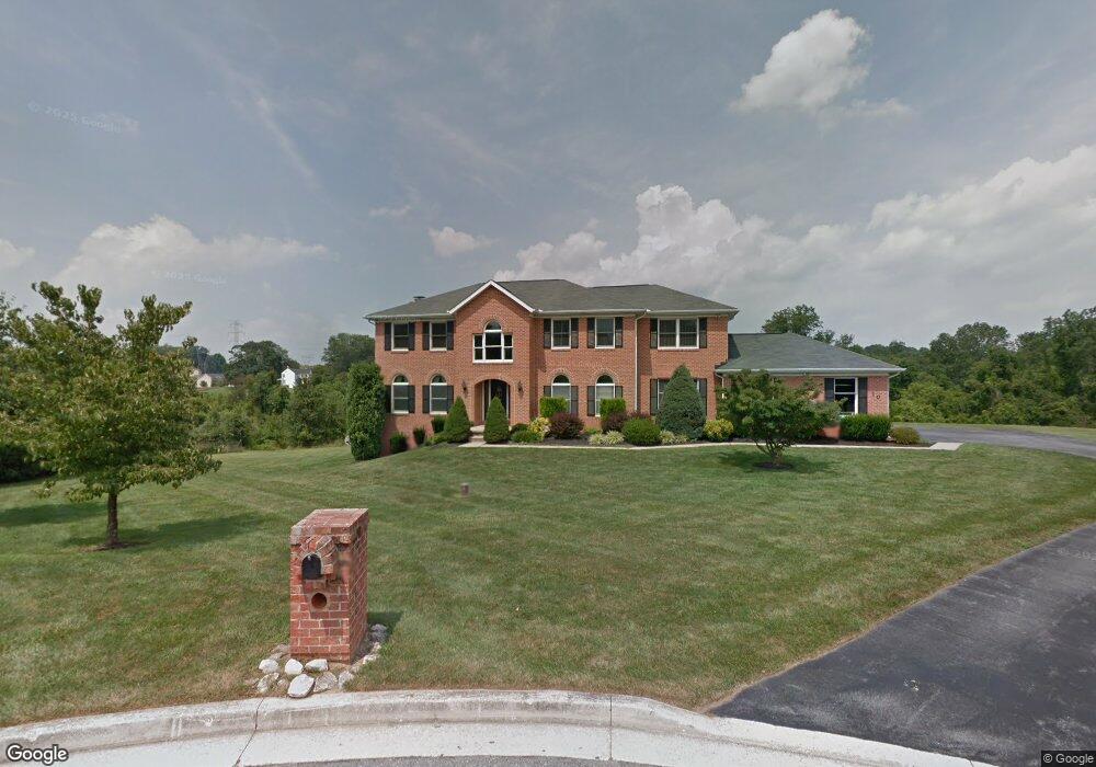
10 Planted Garden Ct Woodstock, MD 21163
Woodstock NeighborhoodEstimated Value: $641,000 - $732,000
--
Bed
3
Baths
3,152
Sq Ft
$211/Sq Ft
Est. Value
About This Home
This home is located at 10 Planted Garden Ct, Woodstock, MD 21163 and is currently estimated at $666,354, approximately $211 per square foot. 10 Planted Garden Ct is a home located in Baltimore County with nearby schools including Hernwood Elementary School, Deer Park Middle Magnet School, and New Town High.
Ownership History
Date
Name
Owned For
Owner Type
Purchase Details
Closed on
Mar 22, 1995
Sold by
Dahan Homes Inc
Bought by
Sanders Andre P
Current Estimated Value
Home Financials for this Owner
Home Financials are based on the most recent Mortgage that was taken out on this home.
Original Mortgage
$296,950
Interest Rate
8.78%
Purchase Details
Closed on
Jan 26, 1995
Sold by
Garriott Charles W Trust
Bought by
Dahan Homes Inc
Home Financials for this Owner
Home Financials are based on the most recent Mortgage that was taken out on this home.
Original Mortgage
$296,950
Interest Rate
8.78%
Create a Home Valuation Report for This Property
The Home Valuation Report is an in-depth analysis detailing your home's value as well as a comparison with similar homes in the area
Home Values in the Area
Average Home Value in this Area
Purchase History
| Date | Buyer | Sale Price | Title Company |
|---|---|---|---|
| Sanders Andre P | $329,967 | -- | |
| Dahan Homes Inc | $77,900 | -- |
Source: Public Records
Mortgage History
| Date | Status | Borrower | Loan Amount |
|---|---|---|---|
| Closed | Dahan Homes Inc | $296,950 |
Source: Public Records
Tax History Compared to Growth
Tax History
| Year | Tax Paid | Tax Assessment Tax Assessment Total Assessment is a certain percentage of the fair market value that is determined by local assessors to be the total taxable value of land and additions on the property. | Land | Improvement |
|---|---|---|---|---|
| 2025 | $6,044 | $529,233 | -- | -- |
| 2024 | $6,044 | $496,000 | $116,100 | $379,900 |
| 2023 | $3,013 | $492,267 | $0 | $0 |
| 2022 | $5,919 | $488,533 | $0 | $0 |
| 2021 | $5,560 | $484,800 | $116,100 | $368,700 |
| 2020 | $5,560 | $480,867 | $0 | $0 |
| 2019 | $5,364 | $476,933 | $0 | $0 |
| 2018 | $5,177 | $473,000 | $110,800 | $362,200 |
| 2017 | $4,918 | $438,900 | $0 | $0 |
| 2016 | $4,500 | $404,800 | $0 | $0 |
| 2015 | $4,500 | $370,700 | $0 | $0 |
| 2014 | $4,500 | $370,700 | $0 | $0 |
Source: Public Records
Map
Nearby Homes
- 2508 Offutt Rd
- 3200 Peddicoat Ct
- 9605 Mendoza Rd
- 3525 Cabot Rd
- 3517 Kings Point Rd
- 3618 Granite Rd
- 10301 Marriottsville Rd
- 10628 Saint Paul Ave
- 3538 Corn Stream Rd
- 3518 Orchard Shade Rd
- 10520 Marriottsville Rd
- 9804 Marriottsville Rd
- 9311 Colorado Ave
- 10719 Old Court Rd
- 30 Sheraton Rd
- 9113 Dogwood Rd
- 3803 Marriottsville Rd
- 9302 Silver Charm Dr
- 9401 Summer Squal Dr
- 3320 Offutt Rd
- 15 Planted Garden Ct
- 6 Planted Garden Ct
- 2 Planted Garden Ct
- 9 Planted Garden Ct
- 2 Morning Mist Ct
- 1 Morning Mist Ct
- 6 Morning Mist Ct
- 5 Morning Mist Ct
- 3120 Granite Rd
- 10 Morning Mist Ct
- 9 Morning Mist Ct
- 3145 Granite Rd
- 3024 Granite Rd
- 3024 Granite Rd
- 3104 Granite Rd
- 15 Morning Mist Ct
- 3024 Granite Hill Dr
- 14 Morning Mist Ct
- 3201 Granite Rd
- 3020 Granite Rd