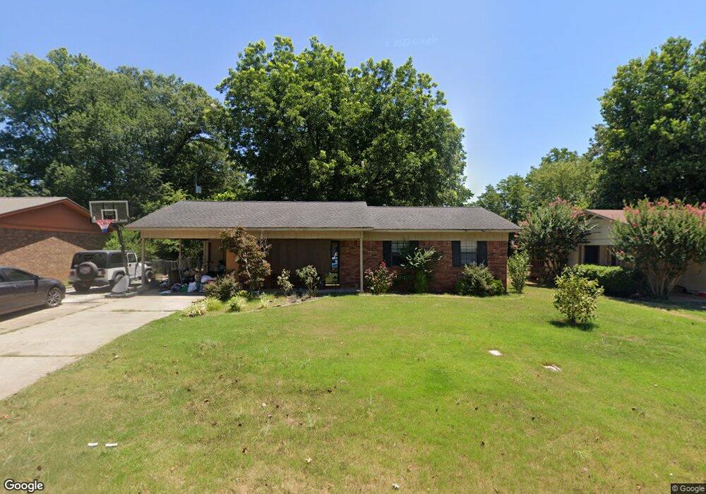
10 Robbye Ln Searcy, AR 72143
Estimated Value: $129,000 - $149,000
3
Beds
1
Bath
1,144
Sq Ft
$122/Sq Ft
Est. Value
About This Home
This home is located at 10 Robbye Ln, Searcy, AR 72143 and is currently estimated at $139,155, approximately $121 per square foot. 10 Robbye Ln is a home located in White County with nearby schools including Westside Elementary School, Southwest Middle School, and Ahlf Junior High School.
Ownership History
Date
Name
Owned For
Owner Type
Purchase Details
Closed on
Jul 22, 2022
Sold by
English Logan G and English Coree E
Bought by
Davis Don and Davis Brianna
Current Estimated Value
Home Financials for this Owner
Home Financials are based on the most recent Mortgage that was taken out on this home.
Original Mortgage
$109,250
Outstanding Balance
$104,064
Interest Rate
5.23%
Mortgage Type
New Conventional
Estimated Equity
$35,091
Purchase Details
Closed on
Aug 10, 2011
Bought by
English
Purchase Details
Closed on
Jul 21, 2009
Sold by
Curtis Patricia K
Bought by
Curtis Patricia K and Curtis Terry
Home Financials for this Owner
Home Financials are based on the most recent Mortgage that was taken out on this home.
Original Mortgage
$69,190
Interest Rate
5.71%
Mortgage Type
FHA
Purchase Details
Closed on
Aug 20, 1997
Bought by
Curtis Patricia K
Purchase Details
Closed on
Sep 1, 1989
Bought by
Stout Carol M
Create a Home Valuation Report for This Property
The Home Valuation Report is an in-depth analysis detailing your home's value as well as a comparison with similar homes in the area
Purchase History
| Date | Buyer | Sale Price | Title Company |
|---|---|---|---|
| Davis Don | $115,000 | Lightle Raney & Streit Llp | |
| English | $85,000 | -- | |
| Curtis Patricia K | -- | -- | |
| Curtis Patricia K | $52,000 | -- | |
| Stout Carol M | $41,000 | -- |
Source: Public Records
Mortgage History
| Date | Status | Borrower | Loan Amount |
|---|---|---|---|
| Open | Davis Don | $109,250 | |
| Previous Owner | Curtis Patricia K | $69,190 |
Source: Public Records
Tax History
| Year | Tax Paid | Tax Assessment Tax Assessment Total Assessment is a certain percentage of the fair market value that is determined by local assessors to be the total taxable value of land and additions on the property. | Land | Improvement |
|---|---|---|---|---|
| 2025 | $704 | $17,340 | $3,600 | $13,740 |
| 2024 | $704 | $17,340 | $3,600 | $13,740 |
| 2023 | $704 | $17,340 | $3,600 | $13,740 |
| 2022 | $704 | $17,340 | $3,600 | $13,740 |
| 2021 | $704 | $17,340 | $3,600 | $13,740 |
| 2020 | $659 | $16,220 | $6,000 | $10,220 |
| 2019 | $659 | $16,220 | $6,000 | $10,220 |
| 2018 | $659 | $16,220 | $6,000 | $10,220 |
| 2017 | $618 | $16,220 | $6,000 | $10,220 |
| 2016 | $618 | $15,230 | $6,000 | $9,230 |
| 2015 | $562 | $13,850 | $4,180 | $9,670 |
| 2014 | $562 | $13,850 | $4,180 | $9,670 |
Source: Public Records
Map
Nearby Homes
- 8 Robbye Ln
- 1903 W Arch Ave
- 32 Stoneybrook Ln
- 28 Stoneybrook Ln
- 19 Hartwell Place
- 42 Stoneybrook Ln
- 1806 W Arch Ave
- 404 S Sawmill Rd
- 2102 Jonathan Ln
- 116 N Sawmill Rd
- 0 Stoneybrook Ln
- 00-Lot C W Beebe Capps Expy
- 0 W Beebe Capps Expy Unit 22023380
- 00-Lot A W Beebe Capps Expy
- 00-Lot B W Beebe Capps Expy
- 318 N Sawmill Rd
- 311 N Sawmill Rd
- 50 Sherwood Loop
- 9 Pepper Tree Place
- 142 John Cyrus Dr
Your Personal Tour Guide
Ask me questions while you tour the home.