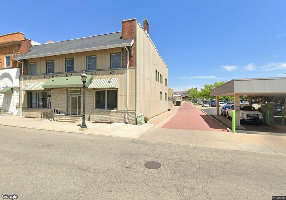
10 S Division Ave Fremont, MI 49412
--
Bed
--
Bath
9,652
Sq Ft
2,614
Sq Ft Lot
About This Home
This home is located at 10 S Division Ave, Fremont, MI 49412. 10 S Division Ave is a home located in Newaygo County with nearby schools including Daisy Brook Elementary School, Pathfinder Elementary School, and Quest High School.
Ownership History
Date
Name
Owned For
Owner Type
Purchase Details
Closed on
May 6, 2015
Sold by
Mellema Paul V and Mellema Sally
Bought by
Mellema Paul and Mellema Sally
Purchase Details
Closed on
Oct 8, 2013
Sold by
Rose Property Management Llc
Bought by
Mellema Paul and Mellema Sally
Purchase Details
Closed on
Jul 3, 2012
Sold by
First United Financial Limited Partnersh
Bought by
Rose Property Management Llc
Purchase Details
Closed on
May 1, 2011
Sold by
Rose Acceptance Inc
Bought by
First United Financial Limited Partner
Purchase Details
Closed on
Feb 10, 2009
Sold by
Brenner Raymond
Bought by
Rose Acceptance Inc
Purchase Details
Closed on
Mar 29, 2006
Sold by
Heeringa Marilyn V
Bought by
Phillips Marjorie
Create a Home Valuation Report for This Property
The Home Valuation Report is an in-depth analysis detailing your home's value as well as a comparison with similar homes in the area
Home Values in the Area
Average Home Value in this Area
Purchase History
| Date | Buyer | Sale Price | Title Company |
|---|---|---|---|
| Mellema Paul | -- | -- | |
| Mellema Paul | -- | Lighthouse Title Agency | |
| Rose Property Management Llc | -- | -- | |
| First United Financial Limited Partner | -- | -- | |
| Rose Acceptance Inc | $236,525 | -- | |
| Phillips Marjorie | $395,000 | -- |
Source: Public Records
Tax History Compared to Growth
Tax History
| Year | Tax Paid | Tax Assessment Tax Assessment Total Assessment is a certain percentage of the fair market value that is determined by local assessors to be the total taxable value of land and additions on the property. | Land | Improvement |
|---|---|---|---|---|
| 2025 | $9,269 | $175,000 | $0 | $0 |
| 2024 | $77 | $182,700 | $0 | $0 |
| 2023 | $7,976 | $166,200 | $0 | $0 |
| 2022 | $8,506 | $129,100 | $0 | $0 |
| 2021 | $8,884 | $126,000 | $0 | $0 |
| 2020 | $9,578 | $136,900 | $0 | $0 |
| 2019 | $9,012 | $138,900 | $0 | $0 |
| 2018 | $9,808 | $146,500 | $0 | $0 |
| 2017 | $9,621 | $142,100 | $0 | $0 |
| 2016 | $4,325 | $72,800 | $0 | $0 |
| 2015 | -- | $72,700 | $0 | $0 |
| 2014 | -- | $68,500 | $0 | $0 |
Source: Public Records
Map
Nearby Homes
- 116 E Sheridan St
- 17 E Oak St
- 320 S Division Ave
- 109 E Pine St
- 318 E Dayton St
- 109 W Woodrow St
- 333 E Elm St
- 343 E Maple St
- 121 N Decker Ave
- 340 E Cherry St
- 501 S Sullivan Ave
- 347 E Pine St
- 518 S Sullivan Ave
- 519 W Oak St
- 421 Cherokee Dr
- 521 E Pine St
- 734 N Stewart Ave
- 601 E Oak St
- 13 Fremont Ave
- 415 Vista Ln