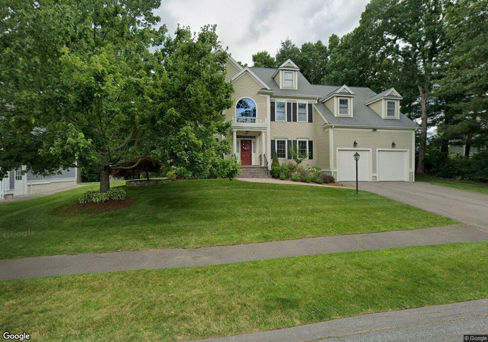
10 Samuel Path Natick, MA 01760
Estimated Value: $1,576,656 - $1,812,000
4
Beds
3
Baths
3,472
Sq Ft
$474/Sq Ft
Est. Value
About This Home
This home is located at 10 Samuel Path, Natick, MA 01760 and is currently estimated at $1,647,414, approximately $474 per square foot. 10 Samuel Path is a home located in Middlesex County with nearby schools including Natick High School, J F Kennedy Middle School, and Johnson Elementary School.
Ownership History
Date
Name
Owned For
Owner Type
Purchase Details
Closed on
Jan 12, 2004
Sold by
B & B Land Corp
Bought by
Heller Gregory C and Heller Kim
Current Estimated Value
Home Financials for this Owner
Home Financials are based on the most recent Mortgage that was taken out on this home.
Original Mortgage
$696,000
Outstanding Balance
$325,040
Interest Rate
5.88%
Mortgage Type
Purchase Money Mortgage
Estimated Equity
$1,322,374
Create a Home Valuation Report for This Property
The Home Valuation Report is an in-depth analysis detailing your home's value as well as a comparison with similar homes in the area
Home Values in the Area
Average Home Value in this Area
Purchase History
| Date | Buyer | Sale Price | Title Company |
|---|---|---|---|
| Heller Gregory C | $870,000 | -- |
Source: Public Records
Mortgage History
| Date | Status | Borrower | Loan Amount |
|---|---|---|---|
| Open | Heller Gregory C | $696,000 |
Source: Public Records
Tax History
| Year | Tax Paid | Tax Assessment Tax Assessment Total Assessment is a certain percentage of the fair market value that is determined by local assessors to be the total taxable value of land and additions on the property. | Land | Improvement |
|---|---|---|---|---|
| 2025 | $17,291 | $1,445,700 | $487,300 | $958,400 |
| 2024 | $16,707 | $1,362,700 | $461,700 | $901,000 |
| 2023 | $15,310 | $1,211,200 | $429,800 | $781,400 |
| 2022 | $14,930 | $1,119,200 | $387,900 | $731,300 |
| 2021 | $3,366 | $1,065,200 | $382,800 | $682,400 |
| 2020 | $4,867 | $1,049,900 | $367,500 | $682,400 |
| 2019 | $7,871 | $994,500 | $367,500 | $627,000 |
| 2018 | $3,309 | $974,800 | $354,700 | $620,100 |
| 2017 | $12,830 | $951,100 | $342,700 | $608,400 |
| 2016 | $12,832 | $945,600 | $342,700 | $602,900 |
| 2015 | $12,289 | $889,200 | $342,700 | $546,500 |
Source: Public Records
Map
Nearby Homes
- 5 Lanes End
- 34 Walden Dr Unit 5
- 30 Walden Dr Unit 7
- 8 Walden Dr Unit 13
- 1 Post Oak Ln Unit 19
- 46 Silver Hill Ln Unit 1
- 3 Silver Hill Ln Unit 6
- 36 Silver Hill Ln Unit 21
- 52 Village Brook Ln Unit 14
- 27 Stillman St
- 26 Wellesley Ave Unit B
- 57 Village Brook Ln Unit 5
- 79 Speen St
- 28 Sylvester Rd
- 8 Village Way Unit 11
- 44 Village Hill Ln
- 29 Village Rock Ln Unit 6
- 15 Village Way Unit 8
- 4 Village Rock Ln Unit 9
- 21 Village Rock Ln Unit 4
- 8 Samuel Path
- 33 Pheasant Hollow Rd
- 31 Pheasant Hollow Rd
- 2 Samuel Path
- 6 Samuel Path
- 13 Samuel Path
- 17 Samuel Path
- 29 Pheasant Hollow Rd
- 15 Samuel Path
- 4 Samuel Path
- 35 Pheasant Hollow Rd
- 35 Pheasant Hollow Rd Unit S.Family
- 35 Pheasant Hollow Rd Unit 35
- 11 Samuel Path
- 1 Katie Path
- 1 Samuel Path
- 30 Pheasant Hollow Rd
- 19 Lanes End
- 32 Pheasant Hollow Rd
- 23 Lanes End
Your Personal Tour Guide
Ask me questions while you tour the home.