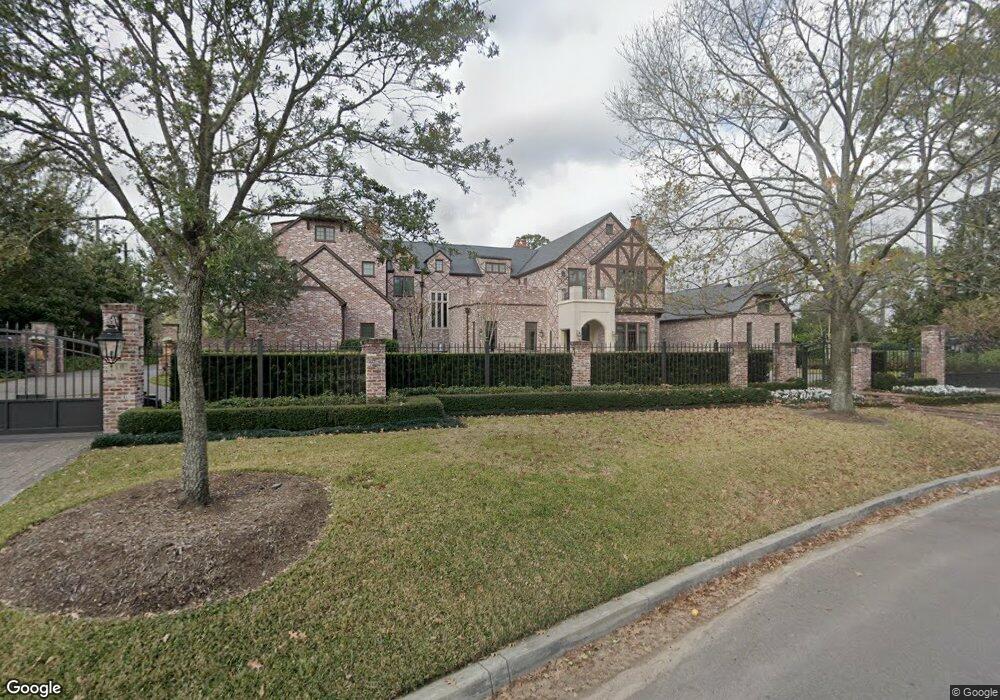
10 Shadder Way Houston, TX 77019
River Oaks NeighborhoodEstimated Value: $6,168,000 - $9,155,435
4
Beds
8
Baths
7,165
Sq Ft
$1,016/Sq Ft
Est. Value
About This Home
This home is located at 10 Shadder Way, Houston, TX 77019 and is currently estimated at $7,280,145, approximately $1,016 per square foot. 10 Shadder Way is a home located in Harris County with nearby schools including River Oaks Elementary School, Lanier Middle School, and Lamar High School.
Ownership History
Date
Name
Owned For
Owner Type
Purchase Details
Closed on
May 14, 2010
Sold by
Newar Adam J and Katz Evelyn Anne
Bought by
Delery Kenneth J and Delery Molly M
Current Estimated Value
Purchase Details
Closed on
Jun 1, 2000
Sold by
Susman Stephen Daily
Bought by
Newar Adam J and Newar Evelyn A
Home Financials for this Owner
Home Financials are based on the most recent Mortgage that was taken out on this home.
Original Mortgage
$1,000,000
Interest Rate
7.37%
Purchase Details
Closed on
Oct 5, 1995
Sold by
Nikel F Donald
Bought by
Susman Karen H
Create a Home Valuation Report for This Property
The Home Valuation Report is an in-depth analysis detailing your home's value as well as a comparison with similar homes in the area
Home Values in the Area
Average Home Value in this Area
Purchase History
| Date | Buyer | Sale Price | Title Company |
|---|---|---|---|
| Delery Kenneth J | -- | None Available | |
| Newar Adam J | -- | Texas State Title | |
| Susman Karen H | -- | -- |
Source: Public Records
Mortgage History
| Date | Status | Borrower | Loan Amount |
|---|---|---|---|
| Previous Owner | Newar Adam J | $1,000,000 |
Source: Public Records
Tax History Compared to Growth
Tax History
| Year | Tax Paid | Tax Assessment Tax Assessment Total Assessment is a certain percentage of the fair market value that is determined by local assessors to be the total taxable value of land and additions on the property. | Land | Improvement |
|---|---|---|---|---|
| 2025 | $167,530 | $10,000,000 | $5,109,615 | $4,890,385 |
| 2024 | $167,530 | $10,908,691 | $4,768,974 | $6,139,717 |
| 2023 | $167,530 | $10,700,000 | $4,768,974 | $5,931,026 |
| 2022 | $194,977 | $9,887,325 | $4,788,383 | $5,098,942 |
| 2021 | $202,535 | $9,955,600 | $4,788,383 | $5,167,217 |
| 2020 | $204,624 | $8,450,000 | $4,788,383 | $3,661,617 |
| 2019 | $212,210 | $10,000,000 | $4,788,383 | $5,211,617 |
| 2018 | $200,254 | $9,858,300 | $4,788,383 | $5,069,917 |
| 2017 | $258,871 | $10,237,882 | $4,788,383 | $5,449,499 |
| 2016 | $236,195 | $9,871,700 | $4,611,035 | $5,260,665 |
| 2015 | $140,309 | $10,077,000 | $4,611,035 | $5,465,965 |
| 2014 | $140,309 | $6,796,046 | $3,901,645 | $2,894,401 |
Source: Public Records
Map
Nearby Homes
- 102 Asbury St Unit 2803
- 102 Asbury St Unit 1704
- 102 Asbury St Unit 2202
- 102 Asbury St Unit 3703
- 102 Asbury St Unit 1003
- 102 Asbury St Unit 1901
- 102 Asbury St Unit 3501
- 2247 Chilton Rd
- 101 Westcott St Unit 1905
- 101 Westcott St Unit 305
- 1561 Kirby Dr
- 5248 Memorial Dr Unit 5248
- 2413 Brentwood Dr
- 5242 Memorial Dr Unit 5242
- 5222 Memorial Dr Unit 5222
- 20 Tiel Way
- 2117 Chilton Rd
- 207 Malone St
- 126 Detering St Unit D
- 2116 Looscan Ln
- 12 Shadder Way
- 9 Shadder Way
- 11 Shadder Way
- 1406 Kirby Dr
- 1 Shadder Way
- 1059 Kirby Dr
- 1049 Kirby Dr
- 2910 Lazy Lane Blvd
- 1029 Kirby Dr
- 1407 Kirby Dr
- 2920 Lazy Lane Blvd
- 2246 Troon Rd
- 2238 Troon Rd
- 2 Shadder Way
- 2232 Troon Rd
- 1419 Kirby Dr
- 2252 Troon Rd
- 8 Asbury Place
- 8 Asbury Place Unit 2906 B
- 8 Asbury Place Unit 2707 A