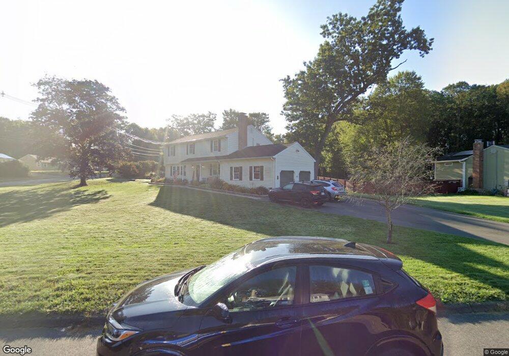
10 Shamrock Cir Windsor, CT 06095
Hayden NeighborhoodEstimated Value: $528,000 - $587,000
5
Beds
4
Baths
3,005
Sq Ft
$182/Sq Ft
Est. Value
About This Home
This home is located at 10 Shamrock Cir, Windsor, CT 06095 and is currently estimated at $546,559, approximately $181 per square foot. 10 Shamrock Cir is a home located in Hartford County with nearby schools including Oliver Ellsworth School, John F. Kennedy School, and Sage Park Middle School.
Ownership History
Date
Name
Owned For
Owner Type
Purchase Details
Closed on
Sep 1, 1998
Sold by
Miller Richard and Miller Georgie
Bought by
Hollowell Russell and Hollowell Deborah
Current Estimated Value
Create a Home Valuation Report for This Property
The Home Valuation Report is an in-depth analysis detailing your home's value as well as a comparison with similar homes in the area
Home Values in the Area
Average Home Value in this Area
Purchase History
| Date | Buyer | Sale Price | Title Company |
|---|---|---|---|
| Hollowell Russell | $169,500 | -- |
Source: Public Records
Mortgage History
| Date | Status | Borrower | Loan Amount |
|---|---|---|---|
| Open | Hollowell Russell | $50,000 | |
| Open | Hollowell Russell | $139,700 | |
| Closed | Hollowell Russell | $140,000 | |
| Closed | Hollowell Russell | $100,000 |
Source: Public Records
Tax History Compared to Growth
Tax History
| Year | Tax Paid | Tax Assessment Tax Assessment Total Assessment is a certain percentage of the fair market value that is determined by local assessors to be the total taxable value of land and additions on the property. | Land | Improvement |
|---|---|---|---|---|
| 2025 | $8,579 | $301,560 | $67,200 | $234,360 |
| 2024 | $9,143 | $301,560 | $67,200 | $234,360 |
| 2023 | $6,470 | $192,570 | $52,080 | $140,490 |
| 2022 | $6,155 | $185,010 | $52,080 | $132,930 |
| 2021 | $6,155 | $185,010 | $52,080 | $132,930 |
| 2020 | $6,126 | $185,010 | $52,080 | $132,930 |
| 2019 | $5,991 | $185,010 | $52,080 | $132,930 |
| 2018 | $5,768 | $175,000 | $52,080 | $122,920 |
| 2017 | $5,679 | $175,000 | $52,080 | $122,920 |
| 2016 | $5,412 | $171,710 | $52,080 | $119,630 |
| 2015 | $5,309 | $171,710 | $52,080 | $119,630 |
| 2014 | $5,232 | $171,710 | $52,080 | $119,630 |
Source: Public Records
Map
Nearby Homes
- 211 MacKtown Rd
- 61 Winthrop Rd
- 957 Palisado Ave
- 24 MacKtown Rd
- 40 Alden Rd
- 680 Kennedy Rd
- 34 Stonehenge Dr
- 1333 Palisado Ave
- 100 Hayden Station Rd
- 625 Palisado Ave Unit 310
- 17 Box Turtle Ln
- 501 Kennedy Rd
- 377 Hayden Station Rd
- 268 High Path Rd Unit 268
- 142 High Path Rd
- 98 High Path Rd
- 55 Foster Ln
- 114 High Path Rd Unit 114
- 701 Meadowview Dr
- 94 Clubhouse Rd
- 16 Shamrock Cir
- 11 Shamrock Cir
- 17 Shamrock Cir
- 192 MacKtown Rd
- 167 MacKtown Rd
- 202 MacKtown Rd
- 180 MacKtown Rd
- 22 Shamrock Cir
- 166 MacKtown Rd
- 23 Shamrock Cir
- 209 MacKtown Rd
- 150 MacKtown Rd
- 161 MacKtown Rd
- 97 Winthrop Rd
- 101 Winthrop Rd
- 14 Riverview Terrace
- 126 MacKtown Rd
- 93 Winthrop Rd
- 22 Riverview Terrace
- 10 Lancaster Dr