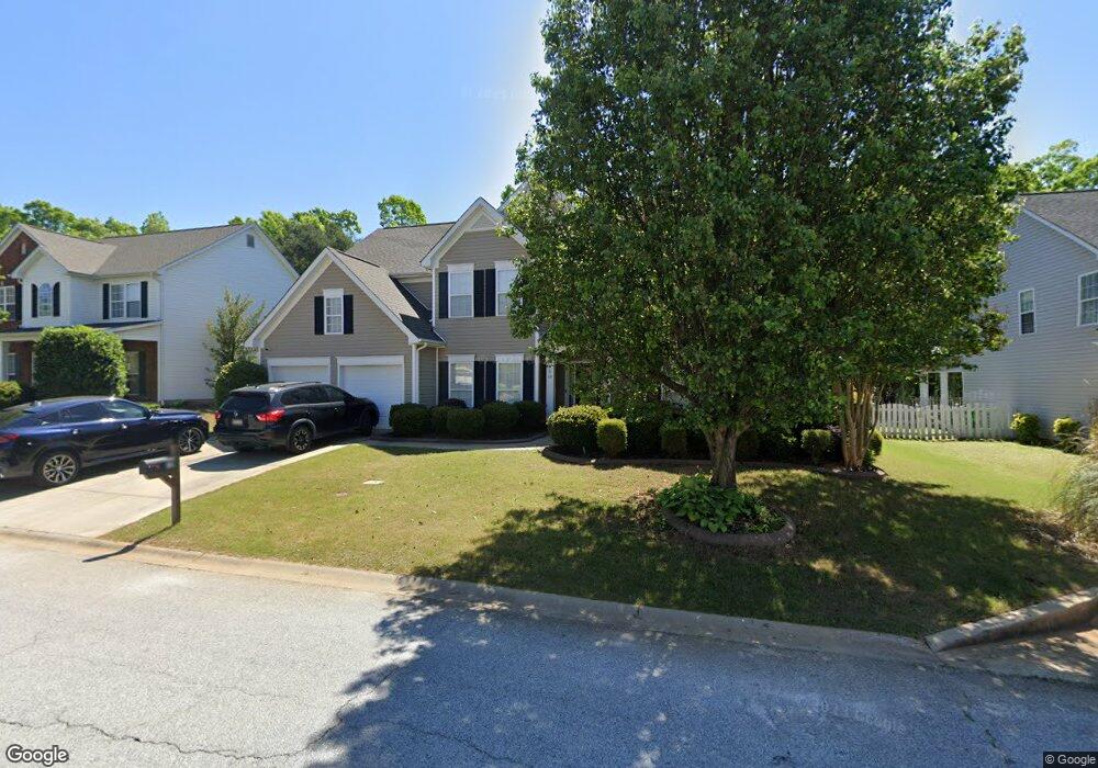
10 Springleaf Ct Simpsonville, SC 29681
Estimated Value: $427,202 - $482,000
4
Beds
4
Baths
2,909
Sq Ft
$157/Sq Ft
Est. Value
About This Home
This home is located at 10 Springleaf Ct, Simpsonville, SC 29681 and is currently estimated at $455,301, approximately $156 per square foot. 10 Springleaf Ct is a home located in Greenville County with nearby schools including Simpsonville Elementary, Hillcrest Middle School, and Hillcrest High School.
Ownership History
Date
Name
Owned For
Owner Type
Purchase Details
Closed on
Feb 12, 2020
Sold by
Hauk Dale and Hauk Kay
Bought by
Silvia Cassandra and Richards Robert
Current Estimated Value
Home Financials for this Owner
Home Financials are based on the most recent Mortgage that was taken out on this home.
Original Mortgage
$228,000
Outstanding Balance
$200,629
Interest Rate
3.72%
Mortgage Type
New Conventional
Estimated Equity
$254,672
Purchase Details
Closed on
Oct 29, 2012
Sold by
Nolan Bruce and Nolan Mary S
Bought by
Hauk Dale and Hauk Kay
Purchase Details
Closed on
May 2, 2003
Sold by
Mdc Homes-Greenville Llc
Bought by
Nolan Bruce
Create a Home Valuation Report for This Property
The Home Valuation Report is an in-depth analysis detailing your home's value as well as a comparison with similar homes in the area
Home Values in the Area
Average Home Value in this Area
Purchase History
| Date | Buyer | Sale Price | Title Company |
|---|---|---|---|
| Silvia Cassandra | $285,000 | None Available | |
| Hauk Dale | $212,500 | -- | |
| Nolan Bruce | $211,240 | -- |
Source: Public Records
Mortgage History
| Date | Status | Borrower | Loan Amount |
|---|---|---|---|
| Open | Silvia Cassandra | $228,000 |
Source: Public Records
Tax History
| Year | Tax Paid | Tax Assessment Tax Assessment Total Assessment is a certain percentage of the fair market value that is determined by local assessors to be the total taxable value of land and additions on the property. | Land | Improvement |
|---|---|---|---|---|
| 2025 | $2,264 | $12,760 | $2,020 | $10,740 |
| 2024 | $2,264 | $11,100 | $1,600 | $9,500 |
| 2023 | $2,180 | $16,640 | $2,400 | $14,240 |
| 2022 | $5,552 | $16,640 | $2,400 | $14,240 |
| 2021 | $5,479 | $16,640 | $2,400 | $14,240 |
| 2020 | $1,383 | $8,410 | $1,280 | $7,130 |
| 2019 | $1,384 | $8,410 | $1,280 | $7,130 |
| 2018 | $1,248 | $8,410 | $1,280 | $7,130 |
| 2017 | $1,248 | $8,410 | $1,280 | $7,130 |
| 2016 | $1,194 | $210,370 | $32,000 | $178,370 |
| 2015 | $1,165 | $206,250 | $32,000 | $174,250 |
| 2014 | $1,159 | $208,010 | $34,000 | $174,010 |
Source: Public Records
Map
Nearby Homes
- 502 Kingsmoor Dr
- 528 Kingsmoor Dr
- 340 Tate Chapman Rd
- 107 Sedgebrook Dr
- 100 Tearose Ln
- 102 Harts Ln
- 3 Old Tree Ct
- 23 Slow Creek Dr
- 214 Benjamine Perry Ct
- 420 Cloverdale Ln
- 6 Worthington Ct
- 31 Laurelhart Ln
- 14 Glen Ivy Dr
- 8 Lone Oak Ave
- 202 Plain Post Trail
- 102 Plain Post Trail
- 106 Plain Post Trail
- 7 Redfield Place
- 5 Redfield Place
- 3 Redfield Place
- 8 Springleaf Ct
- 12 Springleaf Ct
- 6 Springleaf Ct
- 9 Springleaf Ct
- 14 Springleaf Ct
- 7 Springleaf Ct
- 207 Farm Brook Way
- 205 Farm Brook Way
- 209 Farm Brook Way
- 11 Springleaf Ct
- 5 Springleaf Ct
- 209 Farmbrook Way
- 203 Farm Brook Way
- 211 Farm Brook Way
- 4 Springleaf Ct
- 16 Springleaf Ct
- 201 Farm Brook Way
- 15 Springleaf Ct
- 3 Springleaf Ct
- 213 Farm Brook Way
Your Personal Tour Guide
Ask me questions while you tour the home.