
Seller's Agent in 2025
Kaitlin Martel
Martel Real Estate
(978) 852-6259
2 in this area
73 Total Sales
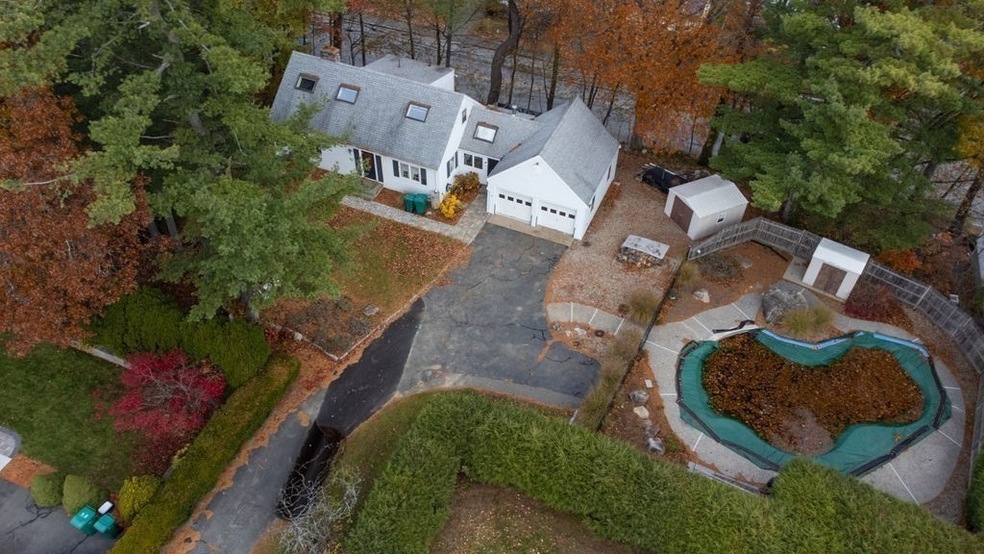


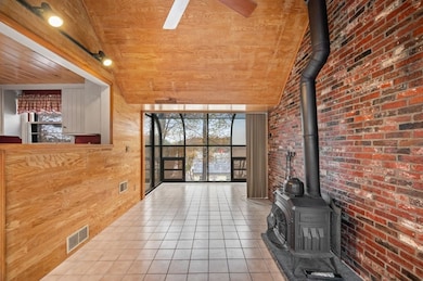
Tucked off the street on a private lot, this well-maintained Cape-style home offers space, warmth, and versatility. Step inside to a charming sitting room featuring a wood stove — the perfect spot to unwind. A sun-filled greenhouse-style bump-out provides an ideal space for a home office, study area, or artist’s nook. The kitchen offers ample cabinet and pantry space, and opens into a bright, inviting dining room. Down the hall, a spacious family room with fireplace provides plenty of room for gatherings. A large bedroom with two cedar-lined closets and a full bath completes this level. Upstairs, you’ll find two more bedrooms and a half bath. A finished room in the lower level adds even more flexibility — perfect for an office, playroom, or bonus living space. Outside, enjoy your own private oasis with an in-ground pool and two-car garage. With its comfortable spaces, and peaceful setting, 10 Standish Way is ready to welcome you home!
| Date | Type | Sale Price | Title Company |
|---|---|---|---|
| Quit Claim Deed | $649,900 | -- | |
| Quit Claim Deed | -- | None Available | |
| Quit Claim Deed | -- | None Available | |
| Quit Claim Deed | -- | None Available | |
| Deed | -- | -- |
| Date | Status | Loan Amount | Loan Type |
|---|---|---|---|
| Open | $617,405 | New Conventional | |
| Previous Owner | $75,000 | No Value Available | |
| Previous Owner | $75,000 | No Value Available | |
| Previous Owner | $56,000 | No Value Available |
| Date | Event | Price | List to Sale | Price per Sq Ft |
|---|---|---|---|---|
| 12/31/2025 12/31/25 | Sold | $649,900 | 0.0% | $368 / Sq Ft |
| 11/25/2025 11/25/25 | Pending | -- | -- | -- |
| 11/13/2025 11/13/25 | For Sale | $649,900 | -- | $368 / Sq Ft |
| Year | Tax Paid | Tax Assessment Tax Assessment Total Assessment is a certain percentage of the fair market value that is determined by local assessors to be the total taxable value of land and additions on the property. | Land | Improvement |
|---|---|---|---|---|
| 2025 | $6,431 | $620,800 | $196,600 | $424,200 |
| 2024 | $6,099 | $579,200 | $188,500 | $390,700 |
| 2023 | $6,167 | $553,100 | $209,900 | $343,200 |
| 2022 | $5,770 | $464,200 | $146,500 | $317,700 |
| 2021 | $5,504 | $422,400 | $148,900 | $273,500 |
| 2020 | $5,340 | $398,500 | $140,800 | $257,700 |
| 2019 | $5,207 | $364,100 | $119,000 | $245,100 |
| 2018 | $5,345 | $352,800 | $142,500 | $210,300 |
| 2017 | $4,881 | $312,900 | $133,100 | $179,800 |
| 2016 | $4,744 | $293,200 | $123,900 | $169,300 |
| 2015 | $4,564 | $272,500 | $122,600 | $149,900 |
Seller's Agent in 2025
Kaitlin Martel
Martel Real Estate
(978) 852-6259
2 in this area
73 Total Sales
Buyer's Agent in 2025
Kirssis Nunez
eXp Realty
(781) 853-3799
5 in this area
85 Total Sales
Source: MLS Property Information Network (MLS PIN)
MLS Number: 73454731
APN: LYNN-000064-000005-000009
Disclaimer: Certain information contained herein is derived from information provided by parties other than Homes.com. All information provided is deemed reliable, but is not guaranteed to be accurate and should be independently verified.
![]() The property listing data and information, or the Images, set forth herein were provided to MLS Property Information Network, Inc. from third party sources, including sellers, lessors and public records, and were compiled by MLS Property Information Network, Inc. The property listing data and information, and the Images, are for the personal, non-commercial use of consumers having a good faith interest in purchasing or leasing listed properties of the type displayed to them and may not be used for any purpose other than to identify prospective properties which such consumers may have a good faith interest in purchasing or leasing. MLS Property Information Network, Inc. and its subscribers disclaim any and all representations and warranties as to the accuracy of the property listing data and information, or as to the accuracy of any of the Images, set forth herein.
The property listing data and information, or the Images, set forth herein were provided to MLS Property Information Network, Inc. from third party sources, including sellers, lessors and public records, and were compiled by MLS Property Information Network, Inc. The property listing data and information, and the Images, are for the personal, non-commercial use of consumers having a good faith interest in purchasing or leasing listed properties of the type displayed to them and may not be used for any purpose other than to identify prospective properties which such consumers may have a good faith interest in purchasing or leasing. MLS Property Information Network, Inc. and its subscribers disclaim any and all representations and warranties as to the accuracy of the property listing data and information, or as to the accuracy of any of the Images, set forth herein.
Ask me questions while you tour the home.