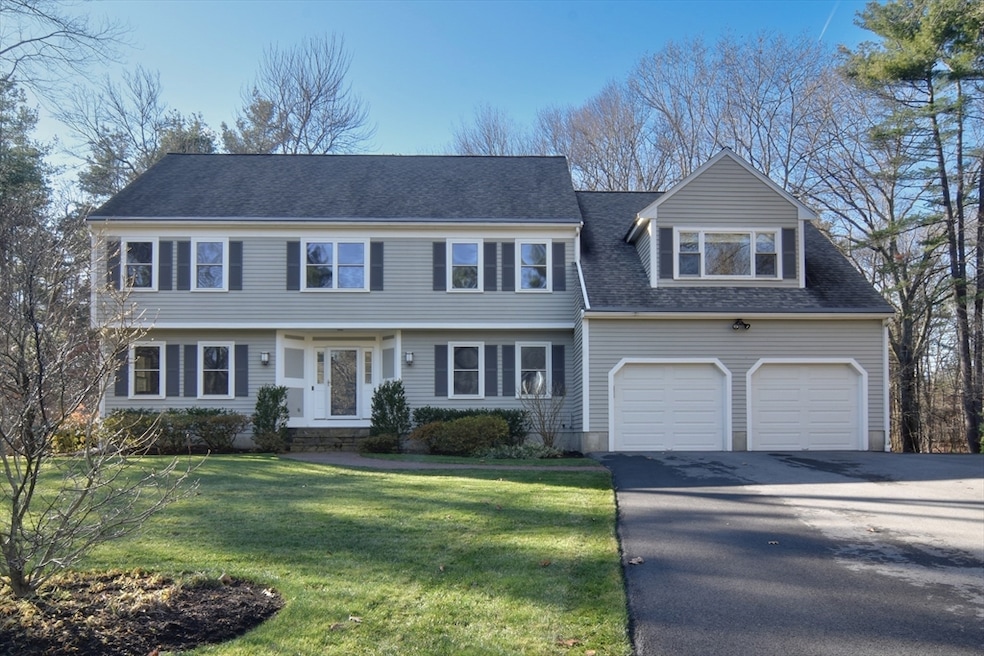
10 Sundance Way Natick, MA 01760
Estimated payment $9,786/month
Highlights
- Medical Services
- 0.92 Acre Lot
- Colonial Architecture
- Natick High School Rated A
- Custom Closet System
- Deck
About This Home
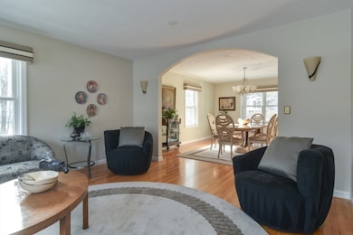
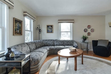
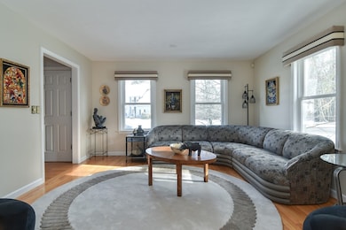
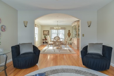
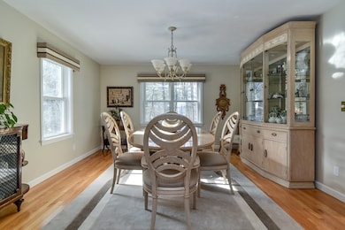
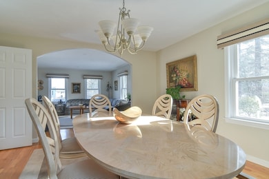
Cherished family home in Natick’s desirable Hamlet Estates, this elegant custom Colonial for the first time on market, offers timeless charm with modern convenience. Recent upgrades include a young roof, refinished hardwoods, newer windows, refreshed kitchen with island & stainless steel appliances, a young oil tank, & more, making this house a breeze to move in to & make yours. The spacious landscaped yard features irrigation, a new driveway, access to the deck, & a spacious screened-in porch with TV & speakers connecting directly to the kitchen & family room—ideal for everyday living & entertaining. The fireplaced, cathedral-ceiling family room, freshly painted office, & easy flow from the kitchen to the dining & living rooms elevate the home’s comfort & functionality. There are 5 bedrooms, 3 full & 2 half baths, plus a finished lower level game room and hangout space. A serene yet convenient location w access to all that Natick has to offer makes this a wonderful place to call home.
Listing Agent
Barber Real Estate Group
William Raveis R.E. & Home Services Listed on: 12/03/2025
Open House Schedule
-
Saturday, December 06, 202512:00 to 1:30 pm12/6/2025 12:00:00 PM +00:0012/6/2025 1:30:00 PM +00:00Add to Calendar
-
Sunday, December 07, 202512:00 to 1:30 pm12/7/2025 12:00:00 PM +00:0012/7/2025 1:30:00 PM +00:00Add to Calendar
Home Details
Home Type
- Single Family
Est. Annual Taxes
- $16,328
Year Built
- Built in 1993
Lot Details
- 0.92 Acre Lot
- Cul-De-Sac
- Sprinkler System
- Wooded Lot
- Property is zoned RSB
Parking
- 2 Car Attached Garage
- Driveway
- Open Parking
- Off-Street Parking
Home Design
- Colonial Architecture
- Garrison Architecture
- Frame Construction
- Shingle Roof
- Radon Mitigation System
- Concrete Perimeter Foundation
Interior Spaces
- Cathedral Ceiling
- Ceiling Fan
- Skylights
- Recessed Lighting
- Insulated Windows
- Sliding Doors
- Insulated Doors
- Mud Room
- Entrance Foyer
- Family Room with Fireplace
- Dining Area
- Home Office
- Game Room
- Storm Doors
Kitchen
- Oven
- Range with Range Hood
- Dishwasher
- Stainless Steel Appliances
- Kitchen Island
- Solid Surface Countertops
Flooring
- Wood
- Wall to Wall Carpet
- Ceramic Tile
Bedrooms and Bathrooms
- 5 Bedrooms
- Primary bedroom located on second floor
- Custom Closet System
- Linen Closet
- Walk-In Closet
- Double Vanity
- Bathtub
- Separate Shower
- Linen Closet In Bathroom
Laundry
- Laundry on main level
- Dryer
- Washer
Finished Basement
- Walk-Out Basement
- Basement Fills Entire Space Under The House
- Interior Basement Entry
Eco-Friendly Details
- Energy-Efficient Thermostat
Outdoor Features
- Deck
- Enclosed Patio or Porch
- Outdoor Storage
- Rain Gutters
Location
- Property is near public transit
- Property is near schools
Schools
- Memorial Elementary School
- Kennedy Middle School
- NHS High School
Utilities
- Forced Air Heating and Cooling System
- Heating System Uses Oil
- Water Heater
Listing and Financial Details
- Assessor Parcel Number M:00000052 P:00000168,674503
Community Details
Overview
- No Home Owners Association
- Near Conservation Area
Amenities
- Medical Services
- Shops
Recreation
- Park
- Jogging Path
Map
Home Values in the Area
Average Home Value in this Area
Tax History
| Year | Tax Paid | Tax Assessment Tax Assessment Total Assessment is a certain percentage of the fair market value that is determined by local assessors to be the total taxable value of land and additions on the property. | Land | Improvement |
|---|---|---|---|---|
| 2025 | $16,328 | $1,365,200 | $517,900 | $847,300 |
| 2024 | $15,769 | $1,286,200 | $489,200 | $797,000 |
| 2023 | $14,453 | $1,143,400 | $454,300 | $689,100 |
| 2022 | $14,259 | $1,068,900 | $409,000 | $659,900 |
| 2021 | $13,636 | $1,001,900 | $386,600 | $615,300 |
| 2020 | $13,407 | $985,100 | $369,800 | $615,300 |
| 2019 | $12,521 | $985,100 | $369,800 | $615,300 |
| 2018 | $11,945 | $915,300 | $353,000 | $562,300 |
| 2017 | $10,501 | $894,300 | $342,200 | $552,100 |
| 2016 | $12,065 | $889,100 | $342,200 | $546,900 |
| 2015 | $11,652 | $843,100 | $342,200 | $500,900 |
Property History
| Date | Event | Price | List to Sale | Price per Sq Ft |
|---|---|---|---|---|
| 12/03/2025 12/03/25 | For Sale | $1,600,000 | -- | $376 / Sq Ft |
Purchase History
| Date | Type | Sale Price | Title Company |
|---|---|---|---|
| Deed | -- | -- | |
| Deed | $389,720 | -- |
Mortgage History
| Date | Status | Loan Amount | Loan Type |
|---|---|---|---|
| Previous Owner | $371,275 | No Value Available | |
| Previous Owner | $300,000 | Purchase Money Mortgage |
Source: MLS Property Information Network (MLS PIN)
MLS Number: 73459632
APN: NATI-000052-000000-000168
Disclaimer: Certain information contained herein is derived from information provided by parties other than Homes.com. All information provided is deemed reliable, but is not guaranteed to be accurate and should be independently verified.
![]() The property listing data and information, or the Images, set forth herein were provided to MLS Property Information Network, Inc. from third party sources, including sellers, lessors and public records, and were compiled by MLS Property Information Network, Inc. The property listing data and information, and the Images, are for the personal, non-commercial use of consumers having a good faith interest in purchasing or leasing listed properties of the type displayed to them and may not be used for any purpose other than to identify prospective properties which such consumers may have a good faith interest in purchasing or leasing. MLS Property Information Network, Inc. and its subscribers disclaim any and all representations and warranties as to the accuracy of the property listing data and information, or as to the accuracy of any of the Images, set forth herein.
The property listing data and information, or the Images, set forth herein were provided to MLS Property Information Network, Inc. from third party sources, including sellers, lessors and public records, and were compiled by MLS Property Information Network, Inc. The property listing data and information, and the Images, are for the personal, non-commercial use of consumers having a good faith interest in purchasing or leasing listed properties of the type displayed to them and may not be used for any purpose other than to identify prospective properties which such consumers may have a good faith interest in purchasing or leasing. MLS Property Information Network, Inc. and its subscribers disclaim any and all representations and warranties as to the accuracy of the property listing data and information, or as to the accuracy of any of the Images, set forth herein.
- 94 Woodland St
- 11 Avon St
- 40 Morse St
- 39 Davis Brook Dr
- 5 Deer Path
- 15 Penobscot Rd
- 20 Walcott St
- 5 Wilson St Unit 5A
- 6B Lincoln St Unit 6B
- 67 E Central St & 5 Union St
- 15 Church St Unit 3
- 4B Lincoln St Unit 4B
- 8 Floral Ave Unit 8
- 3 Wilson St Unit 3B
- 48 S Main St Unit 7
- 62 E Central St Unit 305
- 18 Harvest Moon Dr
- 6 Ambler Ct
- 20 Marion St
- 21 Harvest Moon Dr
- 6 Grant St Unit 2
- 69 E Central St Unit 302
- 69 E Central St Unit 305
- 69 E Central St Unit 309
- 69 E Central St Unit 203
- 69 E Central St
- 45 E Central St
- 45 E Central St Unit 210
- 45 E Central St Unit 405
- 45 E Central St Unit 315
- 45 E Central St Unit 202
- 45 E Central St Unit 303
- 45 E Central St Unit 401
- 31 Pearl St Unit 2
- 103 North Ave Unit 103
- 44 Pond St Unit 44
- 5 Tibbetts St Unit R
- 21 Summer St Unit 303
- 21 Summer St Unit 302
- 21 Summer St