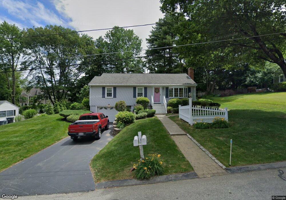
10 Sunset Ln North Grafton, MA 01536
Estimated Value: $461,000 - $507,000
3
Beds
1
Bath
1,212
Sq Ft
$404/Sq Ft
Est. Value
About This Home
This home is located at 10 Sunset Ln, North Grafton, MA 01536 and is currently estimated at $489,659, approximately $404 per square foot. 10 Sunset Ln is a home located in Worcester County with nearby schools including Grafton High School, Silver Spruce Montessori School, and St Stephen Elementary School.
Ownership History
Date
Name
Owned For
Owner Type
Purchase Details
Closed on
Oct 1, 2024
Sold by
Dagle Patricia
Bought by
Dagle Sunset Lane Rt and Welcome
Current Estimated Value
Purchase Details
Closed on
Sep 29, 1983
Bought by
Dagle John M and Dagle Patricia
Create a Home Valuation Report for This Property
The Home Valuation Report is an in-depth analysis detailing your home's value as well as a comparison with similar homes in the area
Home Values in the Area
Average Home Value in this Area
Purchase History
| Date | Buyer | Sale Price | Title Company |
|---|---|---|---|
| Dagle Sunset Lane Rt | -- | None Available | |
| Dagle Sunset Lane Rt | -- | None Available | |
| Dagle Sunset Lane Rt | -- | None Available | |
| Dagle John M | -- | -- |
Source: Public Records
Mortgage History
| Date | Status | Borrower | Loan Amount |
|---|---|---|---|
| Previous Owner | Dagle John M | $60,000 | |
| Previous Owner | Dagle John M | $140,000 | |
| Previous Owner | Dagle John M | $140,000 | |
| Previous Owner | Dagle John M | $58,700 |
Source: Public Records
Tax History Compared to Growth
Tax History
| Year | Tax Paid | Tax Assessment Tax Assessment Total Assessment is a certain percentage of the fair market value that is determined by local assessors to be the total taxable value of land and additions on the property. | Land | Improvement |
|---|---|---|---|---|
| 2025 | $5,855 | $420,000 | $173,000 | $247,000 |
| 2024 | $5,708 | $398,900 | $164,800 | $234,100 |
| 2023 | $5,571 | $354,600 | $164,800 | $189,800 |
| 2022 | $5,260 | $311,600 | $141,500 | $170,100 |
| 2021 | $5,089 | $296,200 | $128,600 | $167,600 |
| 2020 | $4,853 | $294,100 | $128,600 | $165,500 |
| 2019 | $4,633 | $278,100 | $124,900 | $153,200 |
| 2018 | $4,410 | $265,800 | $124,200 | $141,600 |
| 2017 | $4,239 | $258,500 | $116,900 | $141,600 |
| 2016 | $3,935 | $234,900 | $93,900 | $141,000 |
| 2015 | $3,882 | $235,300 | $92,800 | $142,500 |
| 2014 | $3,641 | $238,600 | $109,600 | $129,000 |
Source: Public Records
Map
Nearby Homes
- 11 Hovey Pond Dr Unit 11
- 194 Worcester St
- 22 Beverly Rd
- 14 Northgate Ct Unit 14
- 17 Hingham Rd
- 30 Falmouth Dr
- 4 Westboro Rd
- 44 Meadow Ln
- 0 East St
- 76 Samuel Dr
- 15 Windle Ave
- 21 Lordvale Blvd Unit 406
- 1 Hastings Ave
- 69 Cortland Grove Dr Unit 69
- 5 Lincoln Ln Unit 5
- 4 Winslow Ln Unit 1410
- 51 Cortland Grove Dr Unit 51
- 28 Lincoln Ln
- 46 John Dr Unit 46
- 3 Abby Rd
- 8 Sunset Ln
- 12 Sunset Ln
- 1 Shore Dr
- 2 Shore Dr
- 22 Hovey Pond Dr
- 18 Hovey Pond Dr
- 10 Hovey Pond Dr
- 4 Hovey Pond Dr
- 2 Hovey Pond Dr
- 22 Hovey Pond Dr Unit 22
- 22 Hovey Pond Dr Unit 22 2
- 10 Hovey Pond Dr Unit 10
- 2 Hovey Pond Dr Unit 2
- 18 Hovey Pond Dr Unit 18
- 20 Hovey Pond Dr
- 16 Hovey Pond Dr
- 14 Hovey Pond Dr
- 8 Hovey Pond Dr
- 6 Hovey Pond Dr
- 6 Hovey Pond Dr Unit 203