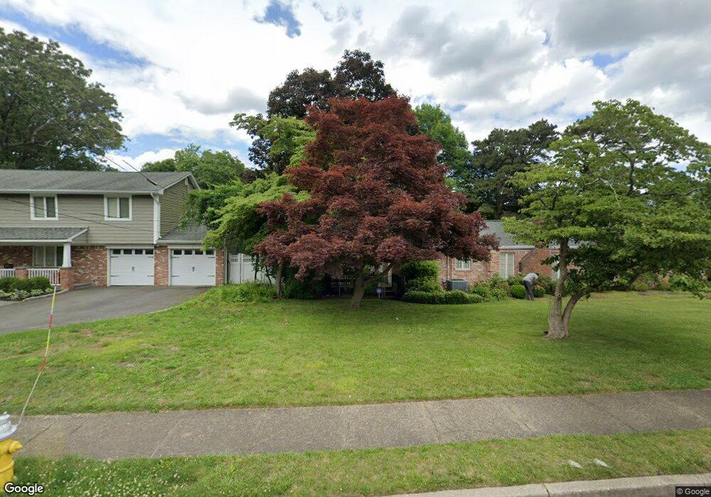
10 The Greens Hauppauge, NY 11788
Estimated Value: $825,000 - $1,041,000
4
Beds
3
Baths
2,963
Sq Ft
$308/Sq Ft
Est. Value
About This Home
This home is located at 10 The Greens, Hauppauge, NY 11788 and is currently estimated at $913,378, approximately $308 per square foot. 10 The Greens is a home located in Suffolk County with nearby schools including Hauppauge Middle School and Hauppauge High School.
Ownership History
Date
Name
Owned For
Owner Type
Purchase Details
Closed on
Feb 5, 2018
Sold by
Dernbach Henry and Dernbach Maureen
Bought by
Forni Charles and Forni Haren
Current Estimated Value
Home Financials for this Owner
Home Financials are based on the most recent Mortgage that was taken out on this home.
Original Mortgage
$300,000
Outstanding Balance
$170,377
Interest Rate
3.95%
Mortgage Type
New Conventional
Estimated Equity
$743,001
Purchase Details
Closed on
Nov 13, 2012
Sold by
Dernbach Henry and Dernbach Maureen
Bought by
Dernbach Henry and Dernbach Maureen
Purchase Details
Closed on
May 27, 2005
Sold by
Marino Robert L
Bought by
Dernbach Henry
Purchase Details
Closed on
Sep 3, 1998
Sold by
Hamlet Windwatch Development Llc
Bought by
Marino Robert L and Marino Zipora
Home Financials for this Owner
Home Financials are based on the most recent Mortgage that was taken out on this home.
Original Mortgage
$165,000
Interest Rate
6.87%
Create a Home Valuation Report for This Property
The Home Valuation Report is an in-depth analysis detailing your home's value as well as a comparison with similar homes in the area
Home Values in the Area
Average Home Value in this Area
Purchase History
| Date | Buyer | Sale Price | Title Company |
|---|---|---|---|
| Forni Charles | $650,000 | -- | |
| Dernbach Henry | -- | -- | |
| Dernbach Henry | $670,000 | James Dimartino | |
| Marino Robert L | $314,000 | Chicago Title Insurance Co |
Source: Public Records
Mortgage History
| Date | Status | Borrower | Loan Amount |
|---|---|---|---|
| Open | Forni Charles | $300,000 | |
| Previous Owner | Marino Robert L | $165,000 |
Source: Public Records
Tax History Compared to Growth
Tax History
| Year | Tax Paid | Tax Assessment Tax Assessment Total Assessment is a certain percentage of the fair market value that is determined by local assessors to be the total taxable value of land and additions on the property. | Land | Improvement |
|---|---|---|---|---|
| 2024 | $16,089 | $74,400 | $12,100 | $62,300 |
| 2023 | $16,089 | $74,400 | $12,100 | $62,300 |
| 2022 | $12,009 | $74,400 | $12,100 | $62,300 |
| 2021 | $12,009 | $74,400 | $12,100 | $62,300 |
| 2020 | $14,343 | $74,400 | $12,100 | $62,300 |
| 2019 | $14,343 | $0 | $0 | $0 |
| 2018 | -- | $74,400 | $12,100 | $62,300 |
| 2017 | $11,843 | $74,400 | $12,100 | $62,300 |
| 2016 | $11,351 | $74,400 | $12,100 | $62,300 |
| 2015 | -- | $74,400 | $12,100 | $62,300 |
| 2014 | -- | $74,400 | $12,100 | $62,300 |
Source: Public Records
Map
Nearby Homes
- 14 Hamlet Dr
- 61 Windwatch Dr
- 97 Windwatch Dr
- 51 Windwatch Dr Unit 51
- 85 Windwatch Dr
- 209 Old Post Dr
- 44 Orchard St
- 424 Evergreen Ave
- 457 Village Dr Unit 457
- 459 Village Dr Unit 459
- 2074 Motor Pkwy
- 231 Sunflower Ln
- 12 Merrimack Rd
- 112 S Bedford Ave
- 1484 Motor Pkwy
- 3 Primrose Ln Unit 3
- 7 Jackson St
- 49 Dorchester Rd
- 71 Sagebrush Ln
- 106 Southern Blvd