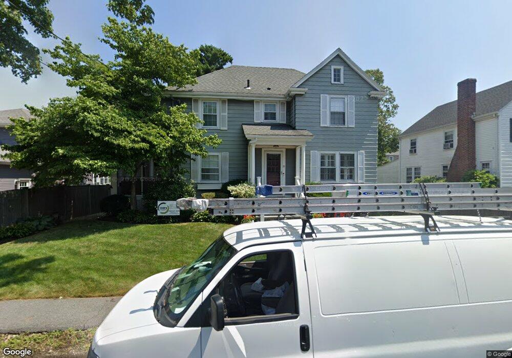
10 Thompson Rd Marblehead, MA 01945
Estimated Value: $927,131 - $1,287,000
3
Beds
2
Baths
1,837
Sq Ft
$576/Sq Ft
Est. Value
About This Home
This home is located at 10 Thompson Rd, Marblehead, MA 01945 and is currently estimated at $1,058,033, approximately $575 per square foot. 10 Thompson Rd is a home located in Essex County with nearby schools including Marblehead High School, Tower School, and Devereux School.
Ownership History
Date
Name
Owned For
Owner Type
Purchase Details
Closed on
Oct 31, 2014
Sold by
Stcyr David and Cyr Adriana S
Bought by
Riffel Michael
Current Estimated Value
Home Financials for this Owner
Home Financials are based on the most recent Mortgage that was taken out on this home.
Original Mortgage
$480,000
Outstanding Balance
$349,079
Interest Rate
3%
Mortgage Type
Adjustable Rate Mortgage/ARM
Estimated Equity
$708,954
Purchase Details
Closed on
Dec 2, 2010
Sold by
Wood Stephen R and Wood Linda B
Bought by
Stcyr David
Home Financials for this Owner
Home Financials are based on the most recent Mortgage that was taken out on this home.
Original Mortgage
$44,000
Interest Rate
4.24%
Create a Home Valuation Report for This Property
The Home Valuation Report is an in-depth analysis detailing your home's value as well as a comparison with similar homes in the area
Home Values in the Area
Average Home Value in this Area
Purchase History
| Date | Buyer | Sale Price | Title Company |
|---|---|---|---|
| Riffel Michael | $600,000 | -- | |
| Stcyr David | $444,000 | -- |
Source: Public Records
Mortgage History
| Date | Status | Borrower | Loan Amount |
|---|---|---|---|
| Open | Riffel Michael | $480,000 | |
| Previous Owner | Stcyr David | $44,000 | |
| Previous Owner | Stcyr David | $352,000 | |
| Previous Owner | Stcyr David | $277,500 | |
| Previous Owner | Stcyr David | $300,000 |
Source: Public Records
Tax History
| Year | Tax Paid | Tax Assessment Tax Assessment Total Assessment is a certain percentage of the fair market value that is determined by local assessors to be the total taxable value of land and additions on the property. | Land | Improvement |
|---|---|---|---|---|
| 2025 | $7,617 | $841,700 | $538,900 | $302,800 |
| 2024 | $7,602 | $848,400 | $550,900 | $297,500 |
| 2023 | $7,317 | $731,700 | $485,000 | $246,700 |
| 2022 | $7,058 | $670,900 | $431,100 | $239,800 |
| 2021 | $6,723 | $645,200 | $407,200 | $238,000 |
| 2020 | $6,384 | $614,400 | $407,200 | $207,200 |
| 2019 | $6,213 | $578,500 | $371,300 | $207,200 |
| 2018 | $6,111 | $554,500 | $347,300 | $207,200 |
| 2017 | $5,970 | $542,200 | $335,300 | $206,900 |
| 2016 | $5,753 | $518,300 | $311,400 | $206,900 |
| 2015 | $5,028 | $453,800 | $263,500 | $190,300 |
| 2014 | $4,631 | $417,600 | $239,500 | $178,100 |
Source: Public Records
Map
Nearby Homes
- 34 Lafayette St
- 4 Dean Rd
- 33 W Shore Dr
- 282 Pleasant St
- 16 Pickwick Rd
- 12 Pickwick Rd
- 70 Maverick St
- 30 Haley Rd Unit 1
- 11 Angenica Terrace
- 212 Humphrey St Unit 205
- 23 Wyman Rd
- 7 Cottage St
- 290 Washington St Unit A
- 41 Atlantic Ave Unit 3
- 41 Atlantic Ave Unit 1
- 6 Mount Vernon St
- 4 Fairview Rd
- 55 Brackett Place Unit B
- 55 Roosevelt Ave
- 1 Knollwood Rd
Your Personal Tour Guide
Ask me questions while you tour the home.