Estimated Value: $545,000 - $687,000
3
Beds
2
Baths
1,905
Sq Ft
$318/Sq Ft
Est. Value
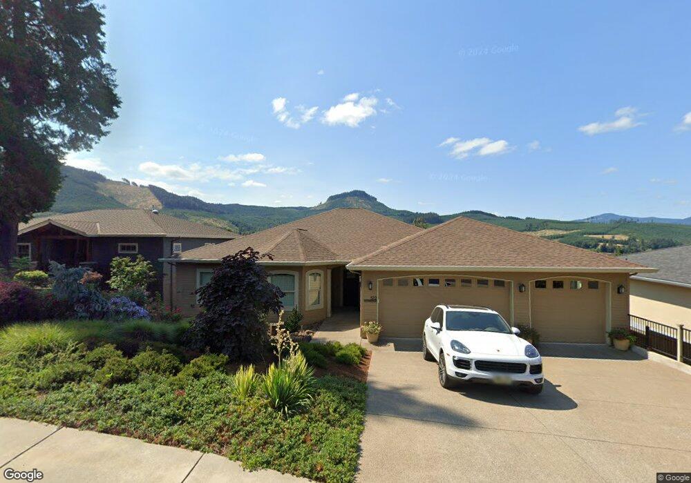
About This Home
This home is located at 10 Unknown Ln, , 00000 and is currently estimated at $605,683, approximately $317 per square foot. 10 Unknown Ln is a home with nearby schools including Lundy Elementary School and Lowell Junior/Senior High School.
Ownership History
Date
Name
Owned For
Owner Type
Purchase Details
Closed on
Aug 26, 2019
Sold by
Federal Home Loan Mortgage Corporation
Bought by
Bennett Mark Gordon
Current Estimated Value
Purchase Details
Closed on
Aug 24, 2019
Sold by
Federal Home Loan Mortgage Corporation
Bought by
Bennett Mark Gordon
Purchase Details
Closed on
Aug 27, 2015
Sold by
Iverson Boyd
Bought by
Bond Jeremy F and Bond Flora M
Home Financials for this Owner
Home Financials are based on the most recent Mortgage that was taken out on this home.
Original Mortgage
$346,500
Interest Rate
4.75%
Mortgage Type
Construction
Purchase Details
Closed on
Apr 21, 2006
Sold by
Shade Tree Inc
Bought by
Baird Todd C
Home Financials for this Owner
Home Financials are based on the most recent Mortgage that was taken out on this home.
Original Mortgage
$56,865
Interest Rate
6.35%
Mortgage Type
Balloon
Create a Home Valuation Report for This Property
The Home Valuation Report is an in-depth analysis detailing your home's value as well as a comparison with similar homes in the area
Purchase History
| Date | Buyer | Sale Price | Title Company |
|---|---|---|---|
| Bennett Mark Gordon | $367,000 | Fidelity Title | |
| Bennett Mark Gordon | $367,000 | None Available | |
| Bond Jeremy F | $372,000 | Evergreen Land Title Co | |
| Baird Todd C | $66,900 | Cascade Title Co |
Source: Public Records
Mortgage History
| Date | Status | Borrower | Loan Amount |
|---|---|---|---|
| Previous Owner | Bond Jeremy F | $346,500 | |
| Previous Owner | Baird Todd C | $56,865 |
Source: Public Records
Tax History
| Year | Tax Paid | Tax Assessment Tax Assessment Total Assessment is a certain percentage of the fair market value that is determined by local assessors to be the total taxable value of land and additions on the property. | Land | Improvement |
|---|---|---|---|---|
| 2025 | $5,932 | $380,984 | -- | -- |
| 2024 | $5,209 | $369,888 | -- | -- |
| 2023 | $5,209 | $359,115 | -- | -- |
| 2022 | $4,892 | $348,656 | $0 | $0 |
| 2021 | $4,758 | $338,501 | $0 | $0 |
| 2020 | $5,421 | $386,456 | $0 | $0 |
| 2019 | $5,214 | $375,200 | $0 | $0 |
| 2018 | $5,053 | $266,410 | $0 | $0 |
| 2017 | $3,368 | $266,410 | $0 | $0 |
| 2016 | $649 | $55,221 | $0 | $0 |
Source: Public Records
Map
Nearby Homes
- 580 Sunridge Ln
- 156 Wetleau Dr
- 0 Wetleau Dr Unit 449078422
- 0 Sunridge Ln Unit 35 24425303
- 0 Sunridge Ln Unit 40 364995201
- 0 Sunridge Ln Unit 41 131748117
- 287 E 3rd St
- 452 Carol St
- 26 E 3rd St
- 0 E 6th St
- 375 Marina Vista Dr
- 40440 Big Fall Creek Rd
- 0 Rogers Ln Unit 2
- 0 Rogers Ln Unit 1
- 38717 Dexter Rd
- 82147 Lost Valley Ln
- 39582 Little Fall Creek Rd
- 39465 Little Fall Creek Rd
- 0 Harolds Rd Unit 23451364
- 39115 Jasper Lowell Rd
- 520 Sunridge Ln
- 172 Wetleau Dr
- 502 Sunridge Ln Unit 23
- 502 Sunridge Ln
- 166 Wetleau Dr
- 526 Sunridge Ln Unit 28
- 515 Sunridge Ln
- 580 Sunridge Ln Unit 49
- 586 Sunridge Ln
- 598 Sunridge Ln
- 595 Sunridge Ln
- 561 Sunridge Ln
- 540 Sunridge Ln
- 160 Wetleau Dr
- 503 Sunridge Ln
- 530 Sunridge Ln Unit 30
- 541 Sunridge Ln
- 165 Wetleau Dr
- 534 Sunridge Ln
- 183 Wetleau Dr
Your Personal Tour Guide
Ask me questions while you tour the home.