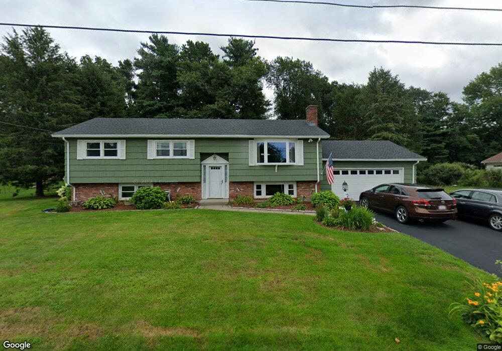
10 Vincent Rd North Grafton, MA 01536
Estimated Value: $471,000 - $536,988
3
Beds
3
Baths
1,236
Sq Ft
$417/Sq Ft
Est. Value
About This Home
This home is located at 10 Vincent Rd, North Grafton, MA 01536 and is currently estimated at $515,247, approximately $416 per square foot. 10 Vincent Rd is a home located in Worcester County with nearby schools including Grafton High School and Silver Spruce Montessori School.
Ownership History
Date
Name
Owned For
Owner Type
Purchase Details
Closed on
Jan 24, 2018
Sold by
Salem Violet N
Bought by
Salem Samuel A and Salem Linda F
Current Estimated Value
Home Financials for this Owner
Home Financials are based on the most recent Mortgage that was taken out on this home.
Original Mortgage
$200,000
Outstanding Balance
$169,126
Interest Rate
3.93%
Mortgage Type
New Conventional
Estimated Equity
$346,121
Purchase Details
Closed on
Sep 14, 1966
Bought by
Salem Violet N
Create a Home Valuation Report for This Property
The Home Valuation Report is an in-depth analysis detailing your home's value as well as a comparison with similar homes in the area
Home Values in the Area
Average Home Value in this Area
Purchase History
| Date | Buyer | Sale Price | Title Company |
|---|---|---|---|
| Salem Samuel A | $300,000 | -- | |
| Salem Samuel A | $300,000 | -- | |
| Salem Samuel A | $300,000 | -- | |
| Salem Violet N | -- | -- |
Source: Public Records
Mortgage History
| Date | Status | Borrower | Loan Amount |
|---|---|---|---|
| Open | Salem Samuel A | $200,000 | |
| Closed | Salem Samuel A | $200,000 | |
| Previous Owner | Salem Violet N | $40,000 | |
| Previous Owner | Salem Violet N | $40,000 |
Source: Public Records
Tax History Compared to Growth
Tax History
| Year | Tax Paid | Tax Assessment Tax Assessment Total Assessment is a certain percentage of the fair market value that is determined by local assessors to be the total taxable value of land and additions on the property. | Land | Improvement |
|---|---|---|---|---|
| 2025 | $6,345 | $455,200 | $183,600 | $271,600 |
| 2024 | $6,259 | $437,400 | $174,800 | $262,600 |
| 2023 | $6,019 | $383,100 | $174,800 | $208,300 |
| 2022 | $5,656 | $335,100 | $150,000 | $185,100 |
| 2021 | $5,168 | $300,800 | $136,400 | $164,400 |
| 2020 | $4,897 | $296,800 | $136,400 | $160,400 |
| 2019 | $4,835 | $290,200 | $132,400 | $157,800 |
| 2018 | $4,829 | $291,100 | $131,600 | $159,500 |
| 2017 | $4,648 | $283,400 | $123,900 | $159,500 |
| 2016 | $4,146 | $247,500 | $99,500 | $148,000 |
| 2015 | $4,094 | $248,100 | $98,300 | $149,800 |
| 2014 | $3,716 | $243,500 | $116,200 | $127,300 |
Source: Public Records
Map
Nearby Homes
- 8 Vincent Rd
- 9 Carroll Manor
- 9 Carroll Manor Unit B9
- 7 Carroll Manor
- 7 Carroll Manor Unit A7
- 11 Vincent Rd
- 9 Vincent Rd
- 14 Vincent Rd
- 6 Vincent Rd
- 13 Vincent Rd
- 11 Carroll Manor
- 5 Carroll Manor
- 2 Doris Dr
- 13 Carroll Manor
- 13 Carroll Manor
- 5 Vincent Rd
- 16 Vincent Rd
- 4 Vincent Rd
- 4 Mary Ann Dr
- 3 Carroll Manor