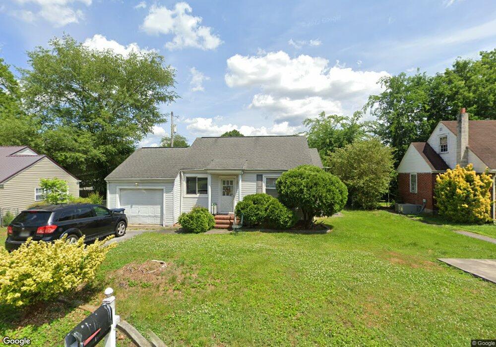
10 Wando Dr Chattanooga, TN 37412
Estimated Value: $184,000 - $190,339
2
Beds
1
Bath
1,041
Sq Ft
$180/Sq Ft
Est. Value
About This Home
This home is located at 10 Wando Dr, Chattanooga, TN 37412 and is currently estimated at $187,085, approximately $179 per square foot. 10 Wando Dr is a home located in Hamilton County with nearby schools including East Ridge Elementary School, East Ridge Middle School, and East Ridge High School.
Ownership History
Date
Name
Owned For
Owner Type
Purchase Details
Closed on
Nov 19, 2025
Sold by
Jack Buttram Iii Ira and Equity Trust Company
Bought by
Krell Daniel Clinton
Current Estimated Value
Home Financials for this Owner
Home Financials are based on the most recent Mortgage that was taken out on this home.
Original Mortgage
$182,360
Outstanding Balance
$182,360
Interest Rate
6.19%
Mortgage Type
New Conventional
Estimated Equity
$4,725
Purchase Details
Closed on
Jun 18, 2003
Sold by
Metcalf Arthur N
Bought by
Metcalf Arthur N and Metcalf Janie A
Home Financials for this Owner
Home Financials are based on the most recent Mortgage that was taken out on this home.
Original Mortgage
$63,750
Interest Rate
5.43%
Mortgage Type
Unknown
Purchase Details
Closed on
Apr 30, 1997
Sold by
Scott Rebecca S
Bought by
Metcalf Arthur N
Home Financials for this Owner
Home Financials are based on the most recent Mortgage that was taken out on this home.
Original Mortgage
$54,950
Interest Rate
7.95%
Mortgage Type
FHA
Purchase Details
Closed on
Apr 25, 1997
Sold by
Scott Robert Stephen
Bought by
Scott Rebecca S
Home Financials for this Owner
Home Financials are based on the most recent Mortgage that was taken out on this home.
Original Mortgage
$54,950
Interest Rate
7.95%
Mortgage Type
FHA
Create a Home Valuation Report for This Property
The Home Valuation Report is an in-depth analysis detailing your home's value as well as a comparison with similar homes in the area
Home Values in the Area
Average Home Value in this Area
Purchase History
| Date | Buyer | Sale Price | Title Company |
|---|---|---|---|
| Krell Daniel Clinton | $188,000 | Ensign Title | |
| Metcalf Arthur N | -- | Woods Christian Title Agency | |
| Metcalf Arthur N | $55,000 | Title Escrow Chattanooga Inc | |
| Scott Rebecca S | -- | Title Escrow Chattanooga Inc |
Source: Public Records
Mortgage History
| Date | Status | Borrower | Loan Amount |
|---|---|---|---|
| Open | Krell Daniel Clinton | $182,360 | |
| Previous Owner | Metcalf Arthur N | $63,750 | |
| Previous Owner | Metcalf Arthur N | $54,950 |
Source: Public Records
Tax History
| Year | Tax Paid | Tax Assessment Tax Assessment Total Assessment is a certain percentage of the fair market value that is determined by local assessors to be the total taxable value of land and additions on the property. | Land | Improvement |
|---|---|---|---|---|
| 2025 | $746 | $49,250 | $0 | $0 |
| 2024 | $630 | $28,150 | $0 | $0 |
| 2023 | $991 | $28,150 | $0 | $0 |
| 2022 | $991 | $28,150 | $0 | $0 |
| 2021 | $1,171 | $28,150 | $0 | $0 |
| 2020 | $543 | $20,550 | $0 | $0 |
| 2019 | $1,032 | $20,550 | $0 | $0 |
| 2018 | $1,032 | $20,550 | $0 | $0 |
| 2017 | $1,032 | $20,550 | $0 | $0 |
| 2016 | $1,014 | $0 | $0 | $0 |
| 2015 | $1,014 | $19,700 | $0 | $0 |
| 2014 | $1,014 | $0 | $0 | $0 |
Source: Public Records
Map
Nearby Homes
- 603 Marlboro Ave
- 502 S Sweetbriar Ave
- 415 Haney Dr
- 4800 Madonna Ave
- 414 Haney Dr
- 306 Asbury Dr
- 615 S Moore Rd
- 905 Blue Heights Dr
- 909 Blue Heights Dr
- 905 Blue Heights Dr Unit 19
- 909 Blue Heights Dr Unit 17
- 719 Belvoir Ave
- 716 Astor Ln
- 123 S Moore Rd
- 703 Belvoir Ave
- 207 S Lovell Ave
- 3839 Terrace
- 520 Bacon Trail
- 315 S Howell Ave
- 198 S Lovell Ave
Your Personal Tour Guide
Ask me questions while you tour the home.