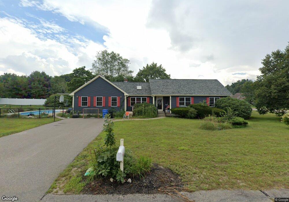
10 Wares Ln Wrentham, MA 02093
Estimated Value: $693,000 - $762,000
3
Beds
2
Baths
2,133
Sq Ft
$339/Sq Ft
Est. Value
About This Home
This home is located at 10 Wares Ln, Wrentham, MA 02093 and is currently estimated at $723,750, approximately $339 per square foot. 10 Wares Ln is a home located in Norfolk County with nearby schools including Delaney Elementary School and Charles E Roderick.
Ownership History
Date
Name
Owned For
Owner Type
Purchase Details
Closed on
Oct 23, 1985
Bought by
Sullivan Paul M and Sullivan Clare A
Current Estimated Value
Create a Home Valuation Report for This Property
The Home Valuation Report is an in-depth analysis detailing your home's value as well as a comparison with similar homes in the area
Home Values in the Area
Average Home Value in this Area
Purchase History
| Date | Buyer | Sale Price | Title Company |
|---|---|---|---|
| Sullivan Paul M | -- | -- |
Source: Public Records
Mortgage History
| Date | Status | Borrower | Loan Amount |
|---|---|---|---|
| Closed | Sullivan Paul M | $19,000 | |
| Open | Sullivan Paul M | $304,000 | |
| Closed | Sullivan Paul M | $215,000 |
Source: Public Records
Tax History Compared to Growth
Tax History
| Year | Tax Paid | Tax Assessment Tax Assessment Total Assessment is a certain percentage of the fair market value that is determined by local assessors to be the total taxable value of land and additions on the property. | Land | Improvement |
|---|---|---|---|---|
| 2025 | $7,516 | $648,500 | $289,200 | $359,300 |
| 2024 | $6,992 | $582,700 | $289,200 | $293,500 |
| 2023 | $6,928 | $549,000 | $263,000 | $286,000 |
| 2022 | $6,955 | $508,800 | $245,400 | $263,400 |
| 2021 | $6,547 | $465,300 | $214,200 | $251,100 |
| 2020 | $6,200 | $435,100 | $190,500 | $244,600 |
| 2019 | $5,881 | $416,500 | $190,500 | $226,000 |
| 2018 | $6,015 | $422,400 | $190,600 | $231,800 |
| 2017 | $5,917 | $415,200 | $186,900 | $228,300 |
| 2016 | $5,791 | $405,500 | $181,500 | $224,000 |
| 2015 | $4,972 | $331,900 | $174,500 | $157,400 |
| 2014 | $5,029 | $328,500 | $167,800 | $160,700 |
Source: Public Records
Map
Nearby Homes
- 570 Franklin St
- 10 Nature View Dr
- 15 Nature View Dr
- 270 Dedham St
- 246 Forest Grove Ave
- 1 Lorraine Metcalf Dr
- 50 Reed Fulton Ave Unit Lot 61
- 45 Joshua Rd
- 131 Creek St Unit 7
- 3 Oak Rd
- 0 W Birch Rd
- 10 W Birch Rd
- 11 Earle Stewart Ln
- 45 King St
- 362 East St
- Lot 3 - 14 Earle Stewart Ln
- Lot 1 - Blueberry 2 Car Plan at King Philip Estates
- Lot 8 - Blueberry 2 Car Plan at King Philip Estates
- Lot 5 - Hughes 2 car Plan at King Philip Estates
- Lot 6 - Blueberry 3 Car Plan at King Philip Estates