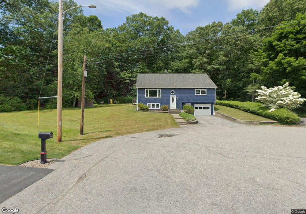
10 Warren St Millbury, MA 01527
Estimated Value: $337,000 - $494,000
3
Beds
2
Baths
1,408
Sq Ft
$306/Sq Ft
Est. Value
About This Home
This home is located at 10 Warren St, Millbury, MA 01527 and is currently estimated at $430,836, approximately $305 per square foot. 10 Warren St is a home located in Worcester County with nearby schools including Elmwood Street Elementary School, Raymond E. Shaw Elementary School, and Millbury Junior/Senior High School.
Ownership History
Date
Name
Owned For
Owner Type
Purchase Details
Closed on
Sep 10, 2014
Sold by
Mignini Mark and Mignini Cynthia A
Bought by
Warren Street Rt and Mignini
Current Estimated Value
Purchase Details
Closed on
Oct 25, 1996
Sold by
Usenia Peter P
Bought by
Mignini Mark and Mignini Cynthia
Home Financials for this Owner
Home Financials are based on the most recent Mortgage that was taken out on this home.
Original Mortgage
$115,400
Interest Rate
8.22%
Mortgage Type
Purchase Money Mortgage
Purchase Details
Closed on
Apr 22, 1994
Sold by
Dorto Henry
Bought by
Usenia Peter P
Create a Home Valuation Report for This Property
The Home Valuation Report is an in-depth analysis detailing your home's value as well as a comparison with similar homes in the area
Home Values in the Area
Average Home Value in this Area
Purchase History
| Date | Buyer | Sale Price | Title Company |
|---|---|---|---|
| Warren Street Rt | -- | -- | |
| Warren Street Rt | -- | -- | |
| Mignini Mark | $121,500 | -- | |
| Mignini Mark | $121,500 | -- | |
| Usenia Peter P | $120,000 | -- | |
| Usenia Peter P | $120,000 | -- |
Source: Public Records
Mortgage History
| Date | Status | Borrower | Loan Amount |
|---|---|---|---|
| Previous Owner | Usenia Peter P | $120,000 | |
| Previous Owner | Usenia Peter P | $115,400 |
Source: Public Records
Tax History
| Year | Tax Paid | Tax Assessment Tax Assessment Total Assessment is a certain percentage of the fair market value that is determined by local assessors to be the total taxable value of land and additions on the property. | Land | Improvement |
|---|---|---|---|---|
| 2025 | $5,040 | $376,400 | $109,100 | $267,300 |
| 2024 | $4,562 | $344,800 | $101,000 | $243,800 |
| 2023 | $4,176 | $289,000 | $70,900 | $218,100 |
| 2022 | $3,929 | $261,900 | $70,900 | $191,000 |
| 2021 | $4,179 | $250,800 | $70,900 | $179,900 |
| 2020 | $31 | $258,800 | $70,900 | $187,900 |
| 2019 | $3,671 | $231,600 | $64,400 | $167,200 |
| 2018 | $5,598 | $222,000 | $64,400 | $157,600 |
| 2017 | $3,309 | $201,400 | $64,400 | $137,000 |
| 2016 | $3,047 | $185,100 | $64,400 | $120,700 |
| 2015 | $3,042 | $184,800 | $68,500 | $116,300 |
| 2014 | $3,169 | $185,300 | $68,500 | $116,800 |
Source: Public Records
Map
Nearby Homes
- 2 Wilson Rd Unit B
- 2 Wilson Rd Unit A
- 2 Riverlin Pkwy
- 25 Upton St
- 8 Lincoln Ave
- 2 Diane St
- 18 Lincoln Ave
- 17 Lincoln Ave
- 300 Millbury Ave
- 10 Logan's Run Unit 10
- 75 Main St
- 7 Canal St
- 12 Irene Ct
- 37-39 Main St
- 0 Worcester Providence Turnpike
- 46 Lexington Rd
- 5 Ann Dr Unit 5
- 4 John Dr
- 38 Garnet St
- Lot 1 Cooper Rd
Your Personal Tour Guide
Ask me questions while you tour the home.