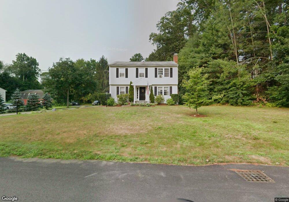
10 Wayne Rd Unit N/A Westford, MA 01886
Estimated Value: $801,000 - $900,000
4
Beds
2
Baths
1,864
Sq Ft
$447/Sq Ft
Est. Value
About This Home
This home is located at 10 Wayne Rd Unit N/A, Westford, MA 01886 and is currently estimated at $833,365, approximately $447 per square foot. 10 Wayne Rd Unit N/A is a home located in Middlesex County with nearby schools including Col John Robinson, John A. Crisafulli Elementary School, and Blanchard Middle School.
Ownership History
Date
Name
Owned For
Owner Type
Purchase Details
Closed on
Jul 8, 2020
Sold by
Morin Jean
Bought by
Jfp Ret
Current Estimated Value
Purchase Details
Closed on
Jun 21, 2017
Sold by
Kjsp Rt
Bought by
Morin Jean
Purchase Details
Closed on
Nov 12, 1998
Sold by
Sullivan Paul D and Sullivan Edward T
Bought by
Kjsp Rt and Sullivan Paul D
Create a Home Valuation Report for This Property
The Home Valuation Report is an in-depth analysis detailing your home's value as well as a comparison with similar homes in the area
Home Values in the Area
Average Home Value in this Area
Purchase History
| Date | Buyer | Sale Price | Title Company |
|---|---|---|---|
| Jfp Ret | -- | None Available | |
| Morin Jean | $500,000 | -- | |
| Kjsp Rt | $30,291 | -- |
Source: Public Records
Mortgage History
| Date | Status | Borrower | Loan Amount |
|---|---|---|---|
| Previous Owner | Kjsp Rt | $50,000 |
Source: Public Records
Tax History Compared to Growth
Tax History
| Year | Tax Paid | Tax Assessment Tax Assessment Total Assessment is a certain percentage of the fair market value that is determined by local assessors to be the total taxable value of land and additions on the property. | Land | Improvement |
|---|---|---|---|---|
| 2025 | $8,751 | $635,500 | $325,400 | $310,100 |
| 2024 | $8,751 | $635,500 | $325,400 | $310,100 |
| 2023 | $8,661 | $586,800 | $309,700 | $277,100 |
| 2022 | $8,653 | $536,800 | $259,700 | $277,100 |
| 2021 | $8,087 | $486,000 | $259,700 | $226,300 |
| 2020 | $7,936 | $486,000 | $259,700 | $226,300 |
| 2019 | $7,719 | $466,100 | $259,700 | $206,400 |
| 2018 | $7,385 | $456,400 | $250,000 | $206,400 |
| 2017 | $6,239 | $380,200 | $250,000 | $130,200 |
| 2016 | $6,033 | $370,100 | $239,100 | $131,000 |
| 2015 | $5,884 | $362,300 | $229,600 | $132,700 |
| 2014 | $5,845 | $352,100 | $220,800 | $131,300 |
Source: Public Records
Map
Nearby Homes
- 254 Concord Rd Unit Lot 2A
- 17 Carlisle Rd
- 14 Fieldstone Dr
- 122 Carlisle Rd
- 1 Fieldstone Dr
- 14 Banbury Dr
- 20 4th Ln
- 9 Drew Crossing
- 5 Carriage Dr
- 4 Drew Crossing
- 84 Powers Rd
- 9 Lakeside Ave
- 32 Vose Hill Rd
- 92 Jimney Dr
- 75 Garrison Rd
- 125 Concord Rd
- 25 Grist Mill Rd
- 1 Courtney Ln
- 1056 Curve St
- 360 Littleton Rd Unit B-1