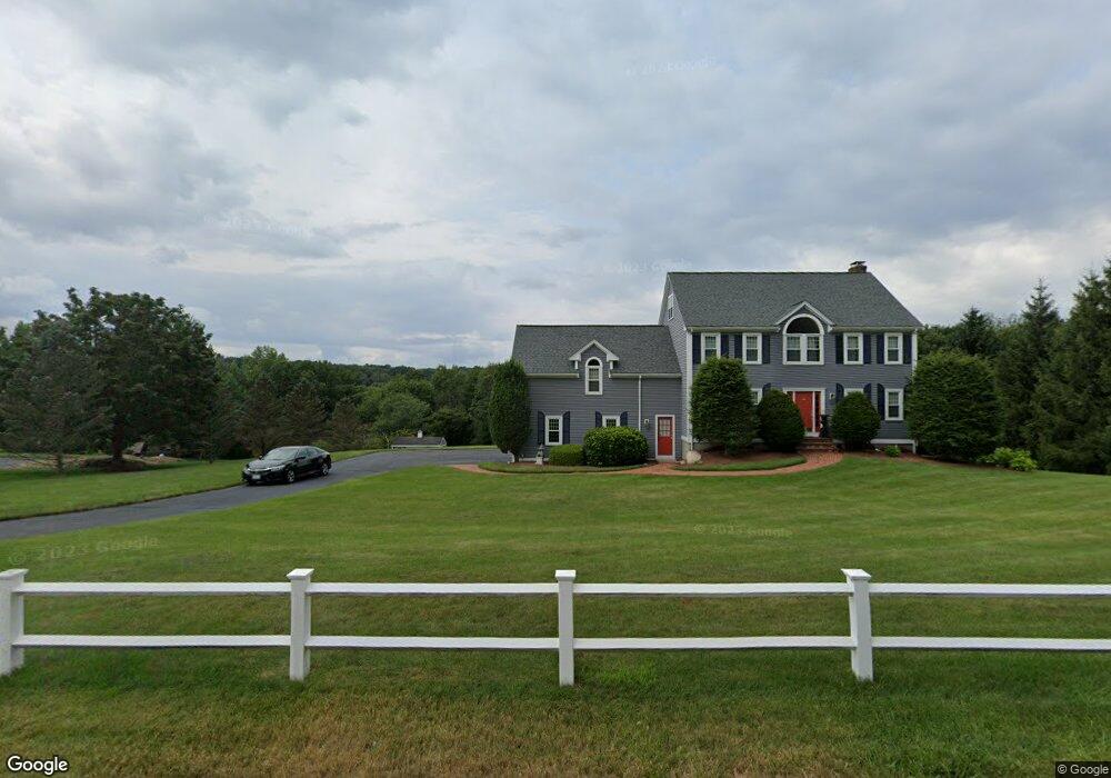
100 Autumn Rd Wrentham, MA 02093
West Wrentham NeighborhoodEstimated Value: $931,377 - $1,124,000
4
Beds
3
Baths
3,229
Sq Ft
$323/Sq Ft
Est. Value
About This Home
This home is located at 100 Autumn Rd, Wrentham, MA 02093 and is currently estimated at $1,042,344, approximately $322 per square foot. 100 Autumn Rd is a home located in Norfolk County with nearby schools including Delaney Elementary School, Charles E Roderick, and Mercymount Country Day School.
Ownership History
Date
Name
Owned For
Owner Type
Purchase Details
Closed on
Apr 2, 1997
Sold by
Riso Nicholas F and Riso Laura D
Bought by
David Anne R and David Ignatius
Current Estimated Value
Home Financials for this Owner
Home Financials are based on the most recent Mortgage that was taken out on this home.
Original Mortgage
$225,000
Outstanding Balance
$28,102
Interest Rate
7.5%
Mortgage Type
Purchase Money Mortgage
Estimated Equity
$1,014,242
Purchase Details
Closed on
Oct 27, 1993
Sold by
Bailey & Zahner Bldrs
Bought by
Riso Nicholas F and Riso Laura D
Home Financials for this Owner
Home Financials are based on the most recent Mortgage that was taken out on this home.
Original Mortgage
$200,000
Interest Rate
6.86%
Mortgage Type
Purchase Money Mortgage
Create a Home Valuation Report for This Property
The Home Valuation Report is an in-depth analysis detailing your home's value as well as a comparison with similar homes in the area
Home Values in the Area
Average Home Value in this Area
Purchase History
| Date | Buyer | Sale Price | Title Company |
|---|---|---|---|
| David Anne R | $293,500 | -- | |
| Riso Nicholas F | $250,000 | -- |
Source: Public Records
Mortgage History
| Date | Status | Borrower | Loan Amount |
|---|---|---|---|
| Open | Riso Nicholas F | $225,000 | |
| Previous Owner | Riso Nicholas F | $15,000 | |
| Previous Owner | Riso Nicholas F | $200,000 |
Source: Public Records
Tax History Compared to Growth
Tax History
| Year | Tax Paid | Tax Assessment Tax Assessment Total Assessment is a certain percentage of the fair market value that is determined by local assessors to be the total taxable value of land and additions on the property. | Land | Improvement |
|---|---|---|---|---|
| 2025 | $9,529 | $822,200 | $293,500 | $528,700 |
| 2024 | $9,150 | $762,500 | $293,500 | $469,000 |
| 2023 | $9,238 | $732,000 | $267,400 | $464,600 |
| 2022 | $8,911 | $651,900 | $260,600 | $391,300 |
| 2021 | $8,494 | $603,700 | $243,900 | $359,800 |
| 2020 | $8,219 | $576,800 | $187,500 | $389,300 |
| 2019 | $7,894 | $559,100 | $187,500 | $371,600 |
| 2018 | $8,335 | $585,300 | $187,300 | $398,000 |
| 2017 | $8,101 | $568,500 | $183,700 | $384,800 |
| 2016 | $7,938 | $555,900 | $178,400 | $377,500 |
| 2015 | $7,902 | $527,500 | $171,500 | $356,000 |
| 2014 | $7,828 | $511,300 | $165,000 | $346,300 |
Source: Public Records
Map
Nearby Homes
- 60 Grant Ave
- 2095 West St
- 50 Heather Ln
- 39 Sumner Brown Rd
- 180 Pine Swamp Rd
- 56 Pine Swamp Rd
- 25 Nature View Dr
- 20 Nature View Dr
- 9 Pebble Cir Unit 9
- 851 Washington St
- 65 Palmetto Dr Unit 65
- 219 Dawn Blvd
- 300 Tower Hill Rd
- 17 Stanford Rd
- 21 Palmetto Dr Unit 21
- 4022 Diamond Hill Rd
- 24 Palmetto Dr Unit 24
- 10 Stanford Rd
- 245 W Wrentham Rd
- 29 Squire Ln