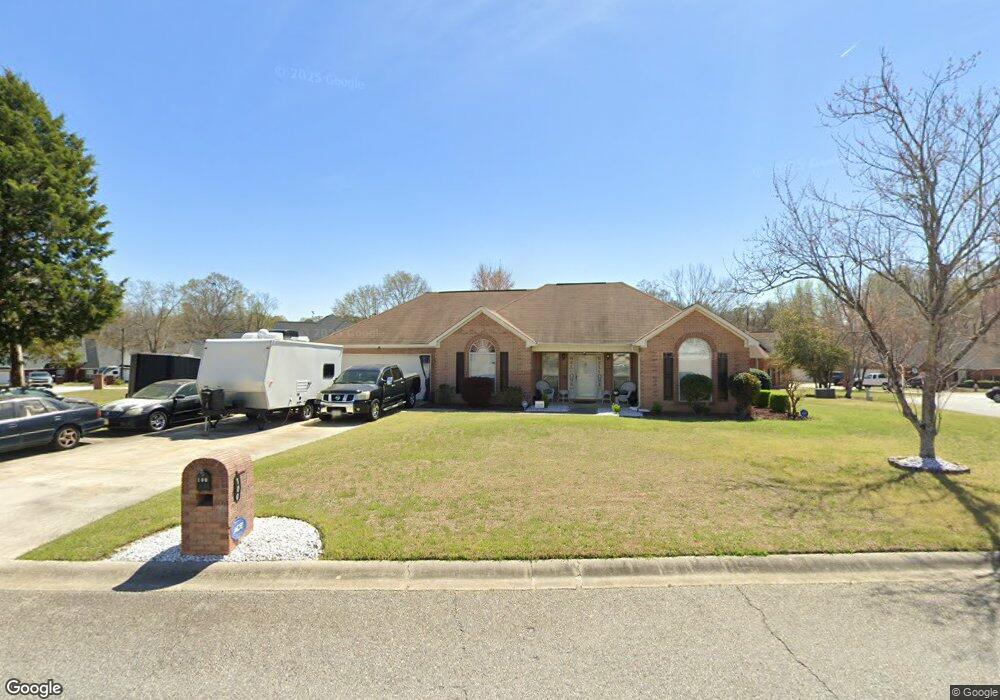
100 Cart Path Way Bonaire, GA 31005
Estimated Value: $227,000 - $248,000
3
Beds
3
Baths
1,635
Sq Ft
$146/Sq Ft
Est. Value
About This Home
This home is located at 100 Cart Path Way, Bonaire, GA 31005 and is currently estimated at $239,121, approximately $146 per square foot. 100 Cart Path Way is a home located in Houston County with nearby schools including Russell Elementary School, Huntington Middle School, and Warner Robins High School.
Ownership History
Date
Name
Owned For
Owner Type
Purchase Details
Closed on
Dec 20, 2000
Sold by
Wallace Virgle E
Bought by
Walker Maurice C and Walker Demetrice L
Current Estimated Value
Purchase Details
Closed on
Dec 12, 1997
Sold by
J Ross Inc
Bought by
Wallace Virgle E
Purchase Details
Closed on
Sep 3, 1997
Sold by
Nationsbank
Bought by
J Ross Inc
Purchase Details
Closed on
Aug 5, 1997
Sold by
Swan Homes Inc
Bought by
Nationsbank
Purchase Details
Closed on
Mar 14, 1997
Sold by
Asbell Max B
Bought by
Swan Homes Inc
Create a Home Valuation Report for This Property
The Home Valuation Report is an in-depth analysis detailing your home's value as well as a comparison with similar homes in the area
Home Values in the Area
Average Home Value in this Area
Purchase History
| Date | Buyer | Sale Price | Title Company |
|---|---|---|---|
| Walker Maurice C | $110,000 | -- | |
| Wallace Virgle E | $115,500 | -- | |
| J Ross Inc | -- | -- | |
| Nationsbank | -- | -- | |
| Swan Homes Inc | -- | -- |
Source: Public Records
Tax History Compared to Growth
Tax History
| Year | Tax Paid | Tax Assessment Tax Assessment Total Assessment is a certain percentage of the fair market value that is determined by local assessors to be the total taxable value of land and additions on the property. | Land | Improvement |
|---|---|---|---|---|
| 2024 | $2,600 | $79,440 | $8,000 | $71,440 |
| 2023 | $2,116 | $64,160 | $6,200 | $57,960 |
| 2022 | $1,384 | $60,200 | $6,200 | $54,000 |
| 2021 | $1,216 | $52,600 | $6,200 | $46,400 |
| 2020 | $1,158 | $49,840 | $6,200 | $43,640 |
| 2019 | $1,158 | $49,840 | $6,200 | $43,640 |
| 2018 | $1,158 | $49,840 | $6,200 | $43,640 |
| 2017 | $1,159 | $49,840 | $6,200 | $43,640 |
| 2016 | $1,161 | $49,840 | $6,200 | $43,640 |
| 2015 | -- | $49,840 | $6,200 | $43,640 |
| 2014 | -- | $49,840 | $6,200 | $43,640 |
| 2013 | -- | $51,800 | $6,200 | $45,600 |
Source: Public Records
Map
Nearby Homes
- 106 Mulligan Ct
- 106 Countrywood Trail
- 105 Fernwood Dr
- 300 Summer Hill Place
- 100 Pebblebrook E
- 207 Summer Hill Place
- 51 Play Golf Dr
- 307 Fleming Dr
- 104 Old Perry Rd
- LOT 25 & 26 Plantation Dr
- 507 Wexford Cir
- 111 Raintree Dr
- 422 Wexford Cir
- 330 Hidden Creek Cir
- 116 Timber Mill Ct
- 105 International Blvd
- 107 Julee Emilyn Dr
- 214 Picketts Mill Ct
- 206 Picketts Mill Ct
- 322 Wilsons Creek Bend
- 200 Cart Path Way
- 200 Links View Dr
- 200 Links View Dr
- 300 Links View Dr
- 103 Cart Path Way
- 105 Cart Path Way
- 202 Cart Path Way
- 203 Links View Dr
- 103 Links View Ct
- 201 Links View Dr
- 302 Links View Dr
- 303 Links View Dr
- 201 Cart Path Way
- 301 Links View Dr
- 105 Links View Ct
- 103 Birdie Dr
- 100 Links View Ct
- 304 Links View Dr
- 204 Cart Path Way
- 305 Links View Dr