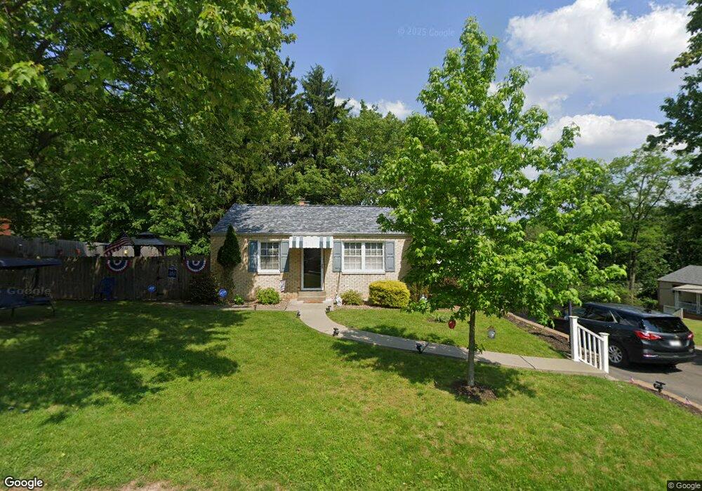
100 Forliview Rd Glenshaw, PA 15116
Shaler Township NeighborhoodEstimated Value: $236,000 - $279,000
3
Beds
2
Baths
888
Sq Ft
$291/Sq Ft
Est. Value
About This Home
This home is located at 100 Forliview Rd, Glenshaw, PA 15116 and is currently estimated at $258,015, approximately $290 per square foot. 100 Forliview Rd is a home located in Allegheny County with nearby schools including Shaler Area Elementary School, Scott Primary School, and Shaler Area Middle School.
Ownership History
Date
Name
Owned For
Owner Type
Purchase Details
Closed on
Apr 20, 2011
Sold by
Samuel Holdings L L C
Bought by
Demma John J
Current Estimated Value
Home Financials for this Owner
Home Financials are based on the most recent Mortgage that was taken out on this home.
Original Mortgage
$37,000
Outstanding Balance
$25,646
Interest Rate
4.9%
Mortgage Type
New Conventional
Estimated Equity
$232,369
Purchase Details
Closed on
Sep 27, 2010
Sold by
United States Of America By Se
Bought by
Samuel Holdings L L C
Home Financials for this Owner
Home Financials are based on the most recent Mortgage that was taken out on this home.
Original Mortgage
$62,000
Interest Rate
4.36%
Mortgage Type
New Conventional
Purchase Details
Closed on
Apr 11, 2002
Sold by
Hagler Kurt
Bought by
Petrokas David L
Purchase Details
Closed on
Apr 27, 1995
Sold by
Hagler Kurt E and Hagler May A
Bought by
Hagler Ward E
Create a Home Valuation Report for This Property
The Home Valuation Report is an in-depth analysis detailing your home's value as well as a comparison with similar homes in the area
Home Values in the Area
Average Home Value in this Area
Purchase History
| Date | Buyer | Sale Price | Title Company |
|---|---|---|---|
| Demma John J | $140,000 | -- | |
| Samuel Holdings L L C | $61,750 | -- | |
| Petrokas David L | $98,500 | -- | |
| Hagler Ward E | $85,000 | -- |
Source: Public Records
Mortgage History
| Date | Status | Borrower | Loan Amount |
|---|---|---|---|
| Open | Demma John J | $37,000 | |
| Previous Owner | Samuel Holdings L L C | $62,000 |
Source: Public Records
Tax History Compared to Growth
Tax History
| Year | Tax Paid | Tax Assessment Tax Assessment Total Assessment is a certain percentage of the fair market value that is determined by local assessors to be the total taxable value of land and additions on the property. | Land | Improvement |
|---|---|---|---|---|
| 2025 | $3,359 | $107,700 | $42,400 | $65,300 |
| 2024 | $3,359 | $102,000 | $42,400 | $59,600 |
| 2023 | $3,239 | $102,000 | $42,400 | $59,600 |
| 2022 | $3,239 | $102,000 | $42,400 | $59,600 |
| 2021 | $482 | $102,000 | $42,400 | $59,600 |
| 2020 | $3,239 | $102,000 | $42,400 | $59,600 |
| 2019 | $3,137 | $102,000 | $42,400 | $59,600 |
| 2018 | $482 | $102,000 | $42,400 | $59,600 |
| 2017 | $3,038 | $102,000 | $42,400 | $59,600 |
| 2016 | $482 | $102,000 | $42,400 | $59,600 |
| 2015 | $482 | $102,000 | $42,400 | $59,600 |
| 2014 | $2,913 | $102,000 | $42,400 | $59,600 |
Source: Public Records
Map
Nearby Homes
- 102 Forliview Rd
- 133 Sunset Ln
- 208 Andrew Dr
- 308 Sandy Dr
- 101 Sunset Dr
- 620 Northaven Cir
- 356 Goldsmith Rd
- 447 Englewood Dr
- 530 Glenhaven Dr
- 113 Mcginley Dr
- 103 Hodil Rd
- 140 Hodil Rd
- 155 Cherrington Dr
- 2501 Oakwood Rd
- 409 Bryn Ct
- 404 McElheny Rd
- 2609 Autumnwood Dr
- 809 Wible Run Rd
- 238 Woodbridge Dr
- 418 Hunter Dr