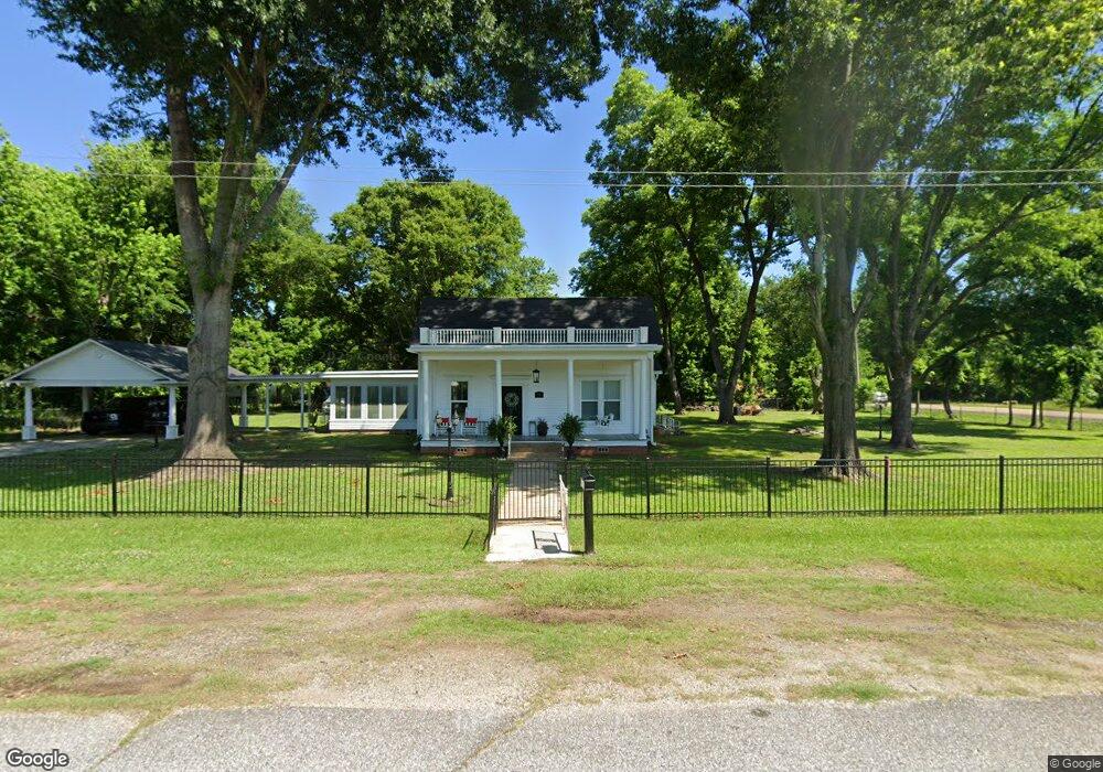
100 Ogan St Fulton, AR 71838
Estimated Value: $96,562 - $102,000
Studio
--
Bath
2,220
Sq Ft
$45/Sq Ft
Est. Value
About This Home
This home is located at 100 Ogan St, Fulton, AR 71838 and is currently estimated at $99,641, approximately $44 per square foot. 100 Ogan St is a home with nearby schools including W.J. Clinton Primary School, Creative Action Team School, and Hope Academy.
Ownership History
Date
Name
Owned For
Owner Type
Purchase Details
Closed on
Aug 29, 2024
Sold by
Maxwell Elizabeth
Bought by
Clark James Otis and Clark Mary
Current Estimated Value
Home Financials for this Owner
Home Financials are based on the most recent Mortgage that was taken out on this home.
Original Mortgage
$95,000
Outstanding Balance
$93,640
Interest Rate
6.77%
Mortgage Type
VA
Estimated Equity
$6,001
Purchase Details
Closed on
May 1, 2023
Sold by
Clark James and Clark Mary
Bought by
Maxwell Elizabeth
Purchase Details
Closed on
May 6, 2022
Sold by
Maxwell Elizabeth
Bought by
Clark James and Clark Mary
Purchase Details
Closed on
Jan 1, 1997
Bought by
Blackwood Otis Wilson and Blackwood C
Create a Home Valuation Report for This Property
The Home Valuation Report is an in-depth analysis detailing your home's value as well as a comparison with similar homes in the area
Purchase History
| Date | Buyer | Sale Price | Title Company |
|---|---|---|---|
| Clark James Otis | $95,000 | Southwest Arkansas Title | |
| Clark James Otis | $95,000 | Southwest Arkansas Title | |
| Maxwell Elizabeth | -- | None Listed On Document | |
| Clark James | -- | Wright Randal | |
| Blackwood Otis Wilson | -- | -- |
Source: Public Records
Mortgage History
| Date | Status | Borrower | Loan Amount |
|---|---|---|---|
| Open | Clark James Otis | $95,000 | |
| Closed | Clark James Otis | $95,000 |
Source: Public Records
Tax History
| Year | Tax Paid | Tax Assessment Tax Assessment Total Assessment is a certain percentage of the fair market value that is determined by local assessors to be the total taxable value of land and additions on the property. | Land | Improvement |
|---|---|---|---|---|
| 2025 | $3 | $12,380 | $690 | $11,690 |
| 2024 | $203 | $12,380 | $690 | $11,690 |
| 2023 | $156 | $12,380 | $690 | $11,690 |
| 2022 | $255 | $12,380 | $690 | $11,690 |
| 2021 | $607 | $12,380 | $690 | $11,690 |
| 2020 | $541 | $9,830 | $550 | $9,280 |
| 2019 | $541 | $9,830 | $550 | $9,280 |
| 2018 | $532 | $9,830 | $550 | $9,280 |
| 2017 | $447 | $9,830 | $550 | $9,280 |
| 2016 | $177 | $9,830 | $550 | $9,280 |
| 2015 | $258 | $13,400 | $590 | $12,810 |
| 2014 | $252 | $13,400 | $590 | $12,810 |
Source: Public Records
Map
Nearby Homes
- 0 Highway 355 S
- 3517 Highway 355 S
- 0 Hempstead 49
- 4407 & 4409 Hempstead 2
- 686 Miller County 379
- 0 Hempstead 310 Rd
- 305 Little River 35
- TBD Little River 35 (40 Acres)
- 0 Hempstead 2
- 0 Hempstead 1042 Rd
- 152 Hempstead 172
- 141 Lakeshore Rd
- 247 Southlake Rd
- 223 Southlake Rd
- 217 Southlake Rd
- 224 Southlake Rd
- 104 Sunset Dr
- 130 Southlake Rd
- 118 Lake Fork Rd
- 210 Ogan St
- 203 Ogan St
- 2864 Highway 195 S
- 201 W Columbus St
- 211 Ogan St
- 105 W Columbus St
- 101 W Columbus St
- 115 W Columbus St
- 417 Little River St
- 200 Ogan St
- 107 Ogan St
- 408 Little River St
- 314 Little River St
- 414 Little River St
- 418 Little River St
- 102 Washington St
- 310 N Orleans St
- 114 Washington St
- 508 Little River St
- 2858 Highway 195 S
Your Personal Tour Guide
Ask me questions while you tour the home.