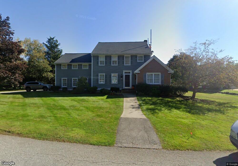
100 Phillips Common North Andover, MA 01845
Estimated Value: $1,034,803 - $1,185,000
4
Beds
3
Baths
2,360
Sq Ft
$473/Sq Ft
Est. Value
About This Home
This home is located at 100 Phillips Common, North Andover, MA 01845 and is currently estimated at $1,115,701, approximately $472 per square foot. 100 Phillips Common is a home located in Essex County with nearby schools including Kittredge Elementary School, North Andover Middle School, and North Andover High School.
Ownership History
Date
Name
Owned For
Owner Type
Purchase Details
Closed on
Apr 5, 1999
Sold by
Higgins Kevin M
Bought by
Radulski Walter T
Current Estimated Value
Purchase Details
Closed on
Dec 13, 1996
Sold by
Essex Street Rt
Bought by
Higgins Kevin M
Purchase Details
Closed on
Sep 10, 1992
Sold by
Phillips Common Rt
Bought by
Essex St Rt
Create a Home Valuation Report for This Property
The Home Valuation Report is an in-depth analysis detailing your home's value as well as a comparison with similar homes in the area
Home Values in the Area
Average Home Value in this Area
Purchase History
| Date | Buyer | Sale Price | Title Company |
|---|---|---|---|
| Radulski Walter T | $369,900 | -- | |
| Higgins Kevin M | $311,750 | -- | |
| Essex St Rt | $249,500 | -- |
Source: Public Records
Mortgage History
| Date | Status | Borrower | Loan Amount |
|---|---|---|---|
| Open | Essex St Rt | $480,000 | |
| Closed | Essex St Rt | $150,000 | |
| Closed | Essex St Rt | $100,000 |
Source: Public Records
Tax History Compared to Growth
Tax History
| Year | Tax Paid | Tax Assessment Tax Assessment Total Assessment is a certain percentage of the fair market value that is determined by local assessors to be the total taxable value of land and additions on the property. | Land | Improvement |
|---|---|---|---|---|
| 2025 | $10,448 | $927,900 | $341,600 | $586,300 |
| 2024 | $9,950 | $897,200 | $323,600 | $573,600 |
| 2023 | $9,471 | $773,800 | $273,300 | $500,500 |
| 2022 | $9,154 | $676,600 | $248,100 | $428,500 |
| 2021 | $8,778 | $619,500 | $224,700 | $394,800 |
| 2020 | $8,512 | $619,500 | $224,700 | $394,800 |
| 2019 | $8,307 | $619,500 | $224,700 | $394,800 |
| 2018 | $9,001 | $619,500 | $224,700 | $394,800 |
| 2017 | $7,577 | $530,600 | $186,100 | $344,500 |
| 2016 | $7,138 | $500,200 | $185,000 | $315,200 |
| 2015 | $7,644 | $531,200 | $178,500 | $352,700 |
Source: Public Records
Map
Nearby Homes
- 19 Fernview Ave Unit 6
- 19 Fernview Ave Unit 5
- 25 Fernview Ave Unit 8
- 23 Fernview Ave Unit 1
- 35 Fernview Ave Unit 5
- 40 Fernview Ave Unit 11
- 52 Fernview Ave Unit 7
- 90 Edgelawn Ave Unit 1
- 180 Chickering Rd Unit 310C
- 75 Edgelawn Ave Unit 1
- 16 Court St
- 70 Farrwood Ave Unit 7
- 98 Mill Pond
- 3 Great Pond Rd
- 112 Mill Pond
- 115 Mill Pond
- 116 Mill Pond
- 447 Stevens St
- 168 Greene St
- 387 Massachusetts Ave
- 88 Phillips Common
- 114 Phillips Common
- 89 Phillips Common
- 103 Phillips Common
- 109 Phillips Common
- 95 Phillips Common
- 78 Phillips Common
- 117 Phillips Common
- 124 Phillips Common
- 83 Phillips Common
- 125 Phillips Common
- 64 Phillips Common
- 18 Phillips Common
- 75 Phillips Common
- 44 Phillips Common
- 28 Phillips Common
- 67 Phillips Common
- 361 Chickering Rd
- 59 Phillips Common
- 11 Phillips Common