
Seller's Agent in 2025
Lisa Bailey
Berkshire Hathaway HomeServices Evolution Properties
(774) 210-0153
76 Total Sales

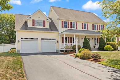

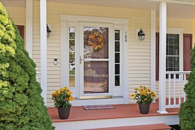


Welcome to Wrentham's Wampanoag Estates, where sidewalk-lined streets & cul-de-sacs create the picture-perfect neighborhood setting. This stately 4-bedroom Colonial blends elegance with everyday comfort, offering 9 foot ceilings & immaculate hardwood floors throughout. A beautifully renovated kitchen flows into the impressive fireplaced family room, creating an open concept gathering spot for family & friends. A first floor bonus room is tucked behind french doors, offering both privacy and accessibility for a home office, kids play room or library. The oversized primary suite is a true retreat with walk-in closet & ensuite bath. The finished basement doubles as the ultimate game room with pool table, media space and add'l bonus room/home gym! Step outside to a fully fenced backyard & relax on the covered porch, perfect for crisp fall evenings. 100 Pokanoket Path; a home that balances sophistication with lifestyle in one of Wrentham’s most desirable communities.
Last Agent to Sell the Property
Berkshire Hathaway HomeServices Evolution Properties Listed on: 09/09/2025
| Date | Type | Sale Price | Title Company |
|---|---|---|---|
| Quit Claim Deed | $1,095,000 | -- | |
| Deed | $668,000 | -- | |
| Deed | $668,000 | -- | |
| Deed | $564,234 | -- | |
| Deed | $564,234 | -- |
| Date | Status | Loan Amount | Loan Type |
|---|---|---|---|
| Open | $876,000 | New Conventional | |
| Previous Owner | $319,600 | No Value Available | |
| Previous Owner | $350,000 | Purchase Money Mortgage | |
| Previous Owner | $396,234 | Purchase Money Mortgage |
| Date | Event | Price | List to Sale | Price per Sq Ft |
|---|---|---|---|---|
| 11/06/2025 11/06/25 | Sold | $1,095,000 | 0.0% | $271 / Sq Ft |
| 09/15/2025 09/15/25 | Pending | -- | -- | -- |
| 09/09/2025 09/09/25 | For Sale | $1,095,000 | -- | $271 / Sq Ft |
| Year | Tax Paid | Tax Assessment Tax Assessment Total Assessment is a certain percentage of the fair market value that is determined by local assessors to be the total taxable value of land and additions on the property. | Land | Improvement |
|---|---|---|---|---|
| 2025 | $11,162 | $963,100 | $301,900 | $661,200 |
| 2024 | $10,589 | $882,400 | $301,900 | $580,500 |
| 2023 | $10,822 | $857,500 | $274,400 | $583,100 |
| 2022 | $9,591 | $701,600 | $211,200 | $490,400 |
| 2021 | $9,455 | $672,000 | $221,300 | $450,700 |
| 2020 | $10,125 | $710,500 | $199,600 | $510,900 |
| 2019 | $9,918 | $702,400 | $215,000 | $487,400 |
| 2018 | $8,525 | $598,700 | $215,200 | $383,500 |
| 2017 | $8,321 | $583,900 | $211,100 | $372,800 |
| 2016 | $8,148 | $570,600 | $205,000 | $365,600 |
| 2015 | $8,317 | $555,200 | $197,000 | $358,200 |
| 2014 | $8,238 | $538,100 | $189,500 | $348,600 |
Seller's Agent in 2025
Lisa Bailey
Berkshire Hathaway HomeServices Evolution Properties
(774) 210-0153
76 Total Sales
Buyer's Agent in 2025
Kelly Panepinto
Berkshire Hathaway HomeServices Commonwealth Real Estate
(781) 254-9489
178 Total Sales
Source: MLS Property Information Network (MLS PIN)
MLS Number: 73426568
APN: WREN-000008K-000006-000016
Disclaimer: Certain information contained herein is derived from information provided by parties other than Homes.com. All information provided is deemed reliable, but is not guaranteed to be accurate and should be independently verified.
![]() The property listing data and information, or the Images, set forth herein were provided to MLS Property Information Network, Inc. from third party sources, including sellers, lessors and public records, and were compiled by MLS Property Information Network, Inc. The property listing data and information, and the Images, are for the personal, non-commercial use of consumers having a good faith interest in purchasing or leasing listed properties of the type displayed to them and may not be used for any purpose other than to identify prospective properties which such consumers may have a good faith interest in purchasing or leasing. MLS Property Information Network, Inc. and its subscribers disclaim any and all representations and warranties as to the accuracy of the property listing data and information, or as to the accuracy of any of the Images, set forth herein.
The property listing data and information, or the Images, set forth herein were provided to MLS Property Information Network, Inc. from third party sources, including sellers, lessors and public records, and were compiled by MLS Property Information Network, Inc. The property listing data and information, and the Images, are for the personal, non-commercial use of consumers having a good faith interest in purchasing or leasing listed properties of the type displayed to them and may not be used for any purpose other than to identify prospective properties which such consumers may have a good faith interest in purchasing or leasing. MLS Property Information Network, Inc. and its subscribers disclaim any and all representations and warranties as to the accuracy of the property listing data and information, or as to the accuracy of any of the Images, set forth herein.
Ask me questions while you tour the home.