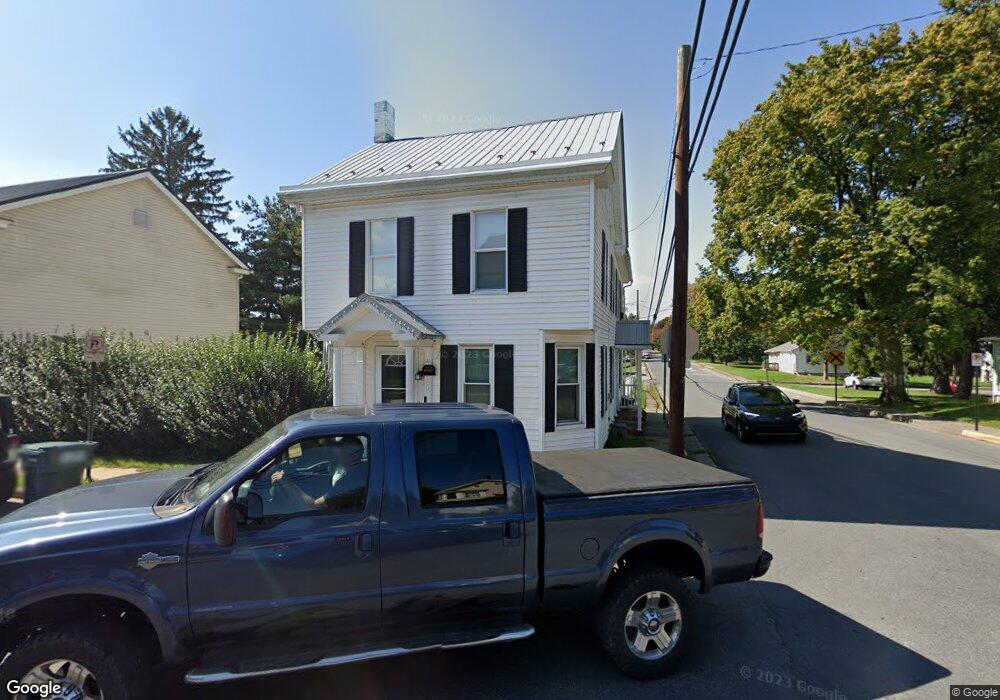
100 S High St Selinsgrove, PA 17870
Estimated Value: $186,000 - $217,000
2
Beds
1
Bath
1,898
Sq Ft
$106/Sq Ft
Est. Value
About This Home
This home is located at 100 S High St, Selinsgrove, PA 17870 and is currently estimated at $201,879, approximately $106 per square foot. 100 S High St is a home located in Snyder County with nearby schools including Selinsgrove Area Elementary School, Selinsgrove Intermediate School, and Selinsgrove Area Middle School.
Ownership History
Date
Name
Owned For
Owner Type
Purchase Details
Closed on
Oct 23, 2020
Sold by
Kreamer Michael S
Bought by
Fegley Tammi J and Fegley Megan A
Current Estimated Value
Home Financials for this Owner
Home Financials are based on the most recent Mortgage that was taken out on this home.
Original Mortgage
$152,781
Outstanding Balance
$135,891
Interest Rate
2.9%
Mortgage Type
FHA
Estimated Equity
$65,988
Purchase Details
Closed on
Jul 17, 2019
Sold by
Knouse Linda
Bought by
Kreamer Michael S
Create a Home Valuation Report for This Property
The Home Valuation Report is an in-depth analysis detailing your home's value as well as a comparison with similar homes in the area
Home Values in the Area
Average Home Value in this Area
Purchase History
| Date | Buyer | Sale Price | Title Company |
|---|---|---|---|
| Fegley Tammi J | $155,600 | Faxon Settlement Svcs Llc | |
| Kreamer Michael S | $57,500 | None Available |
Source: Public Records
Mortgage History
| Date | Status | Borrower | Loan Amount |
|---|---|---|---|
| Open | Fegley Tammi J | $152,781 |
Source: Public Records
Tax History Compared to Growth
Tax History
| Year | Tax Paid | Tax Assessment Tax Assessment Total Assessment is a certain percentage of the fair market value that is determined by local assessors to be the total taxable value of land and additions on the property. | Land | Improvement |
|---|---|---|---|---|
| 2025 | $1,531 | $12,800 | $2,050 | $10,750 |
| 2024 | $1,438 | $12,800 | $2,050 | $10,750 |
| 2023 | $574 | $12,800 | $2,050 | $10,750 |
| 2022 | $1,380 | $12,800 | $2,050 | $10,750 |
| 2021 | $1,367 | $12,800 | $2,050 | $10,750 |
| 2020 | $1,361 | $12,800 | $2,050 | $10,750 |
| 2019 | $1,354 | $12,800 | $2,050 | $10,750 |
| 2018 | $1,341 | $12,800 | $2,050 | $10,750 |
| 2017 | $1,329 | $12,800 | $2,050 | $10,750 |
| 2016 | $714 | $12,800 | $2,050 | $10,750 |
| 2015 | $47,120 | $12,800 | $2,050 | $10,750 |
| 2014 | $47,120 | $12,800 | $2,050 | $10,750 |
Source: Public Records
Map
Nearby Homes
- 211 W Pine St
- 207 Orange St Unit 209
- 00 S Market St
- 223 E Pine St
- 500 N Orange St
- 511 N 10th St
- 722 N 8th St
- Lot 1 522 Route S
- 321 Pleasant Dr
- 12 Minton Dr
- 0 Wedgewood Dr
- 20 Quarry Rd
- 9130 State Route 147
- 456 State School Rd
- 00 Market
- 1262 N Old Trail
- 732 Salem Rd
- 85 Old Colony Rd
- 0 Mill Rd
- 34 Oakmont Ct
- 102 S High St
- 18 S High St Unit B
- 18 S High St
- 104 S High St
- 16 S High St Unit 18
- 111 University Ave
- 101 S High St
- 108 S High St
- 14 S High St
- 14 University Ave
- 110 University Ave
- 12 S High St
- 17 S High St
- 107 S High St
- 101 S Liberty Aly
- 10 S High St
- 109 S High St Unit 1
- 109 S High St
- 117 University Ave
- 112 S High St Unit 1