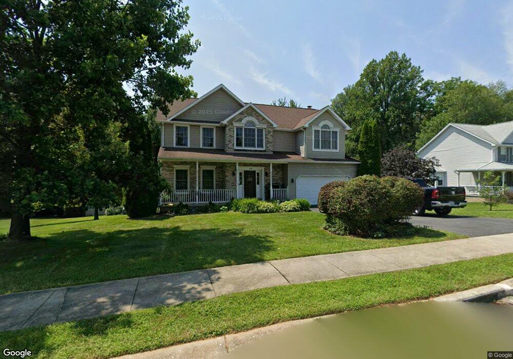
100 S Kennard Dale Ave Stewartstown, PA 17363
Estimated Value: $438,000 - $574,000
4
Beds
3
Baths
2,704
Sq Ft
$183/Sq Ft
Est. Value
About This Home
This home is located at 100 S Kennard Dale Ave, Stewartstown, PA 17363 and is currently estimated at $495,319, approximately $183 per square foot. 100 S Kennard Dale Ave is a home located in York County with nearby schools including South Eastern Intermediate School, South Eastern Middle School, and Kennard-Dale High School.
Ownership History
Date
Name
Owned For
Owner Type
Purchase Details
Closed on
May 25, 2001
Sold by
Rigby Bridget A and Payne James R
Bought by
Favorite John D and Favorite Brenda L
Current Estimated Value
Home Financials for this Owner
Home Financials are based on the most recent Mortgage that was taken out on this home.
Original Mortgage
$180,000
Outstanding Balance
$67,510
Interest Rate
7.09%
Estimated Equity
$427,809
Purchase Details
Closed on
Apr 29, 1999
Sold by
Royal Bldg Inc
Bought by
Payne James R and Rigby Bridget A
Home Financials for this Owner
Home Financials are based on the most recent Mortgage that was taken out on this home.
Original Mortgage
$179,500
Interest Rate
6.95%
Create a Home Valuation Report for This Property
The Home Valuation Report is an in-depth analysis detailing your home's value as well as a comparison with similar homes in the area
Home Values in the Area
Average Home Value in this Area
Purchase History
| Date | Buyer | Sale Price | Title Company |
|---|---|---|---|
| Favorite John D | $225,000 | -- | |
| Payne James R | $224,412 | -- |
Source: Public Records
Mortgage History
| Date | Status | Borrower | Loan Amount |
|---|---|---|---|
| Open | Favorite John D | $180,000 | |
| Previous Owner | Payne James R | $179,500 | |
| Closed | Payne James R | $22,400 | |
| Closed | Favorite John D | $33,750 |
Source: Public Records
Tax History Compared to Growth
Tax History
| Year | Tax Paid | Tax Assessment Tax Assessment Total Assessment is a certain percentage of the fair market value that is determined by local assessors to be the total taxable value of land and additions on the property. | Land | Improvement |
|---|---|---|---|---|
| 2025 | $9,031 | $282,230 | $48,040 | $234,190 |
| 2024 | $9,031 | $282,230 | $48,040 | $234,190 |
| 2023 | $9,031 | $282,230 | $48,040 | $234,190 |
| 2022 | $9,031 | $282,230 | $48,040 | $234,190 |
| 2021 | $8,749 | $282,230 | $48,040 | $234,190 |
| 2020 | $8,749 | $282,230 | $48,040 | $234,190 |
| 2019 | $8,721 | $282,230 | $48,040 | $234,190 |
| 2018 | $8,721 | $282,230 | $48,040 | $234,190 |
| 2017 | $8,721 | $282,230 | $48,040 | $234,190 |
| 2016 | $0 | $282,230 | $48,040 | $234,190 |
| 2015 | -- | $282,230 | $48,040 | $234,190 |
| 2014 | -- | $282,230 | $48,040 | $234,190 |
Source: Public Records
Map
Nearby Homes
- 94 Piston Ct
- 2 S Main St
- 82 Piston Ct
- 9 W Pennsylvania Ave
- 13 Baneberry St
- 17 Charles Ave
- 231 Cool Spring Ln
- 103 Hershey Cir
- 18007 Dave Anne Cir
- 18010 Dave Anne Cir
- 4341 Forbes Dr
- 4303 Forbes Dr
- 18183 Piedmont Rd
- 10 Black Oak Ct
- 150 Patterson Dr Unit 47
- 160 Patterson Dr Unit 48
- 180 Patterson Dr Unit 50
- 2430 Harris Mill Rd
- 8287 Pleasant Valley Rd
- 2 Dutton Rd
- 98 S Kennard Dale Ave
- 102 S Kennard Dale Ave
- 101 S Kennard Dale Ave
- 96 S Kennard Dale Ave
- 104 S Kennard Dale Ave
- 6 Red Spire Ln
- 8 Red Spire Ln
- 8 Red Spire Ln Unit 6/25/2010
- 94 S Kennard Dale Ave
- 105 S Kennard Dale Ave
- 93 S Kennard Dale Ave
- 106 S Kennard Dale Ave
- 92 S Kennard Dale Ave
- 7 Red Spire Ln
- 9 Red Spire Ln
- 5 Red Spire Ln
- 90 S Kennard Dale Ave
- 11 Red Spire Ln
- 13 Red Spire Ln
- 3 Red Spire Ln