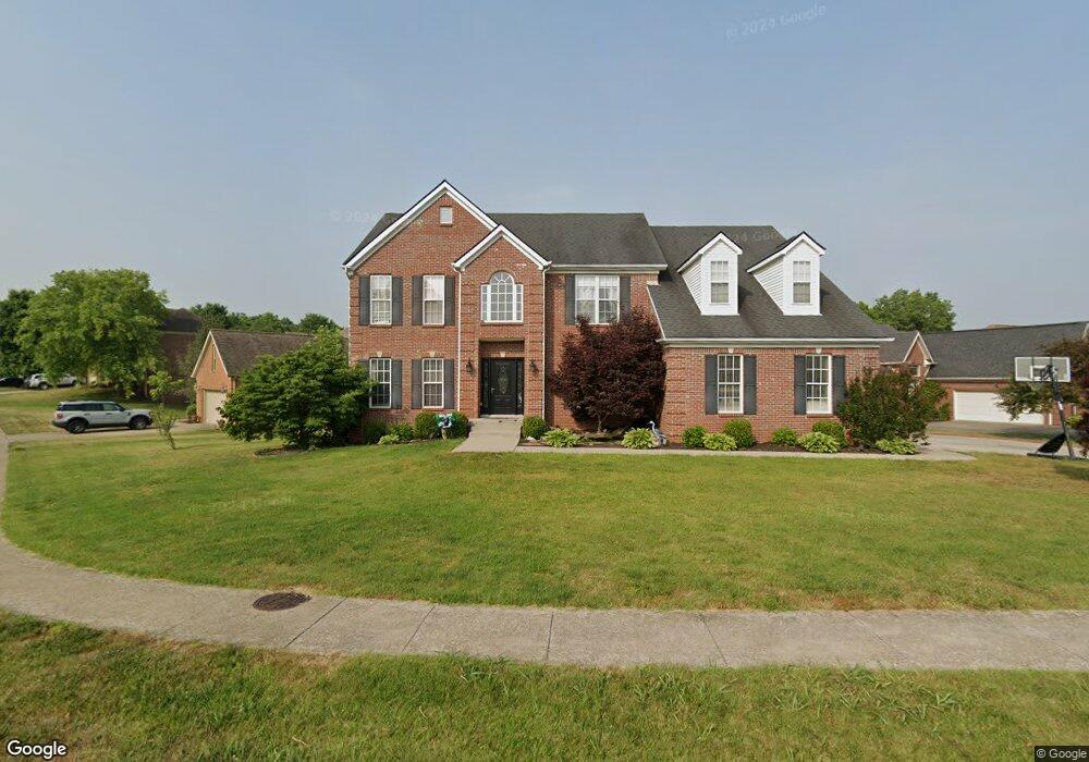
100 Saint Andrews Way Georgetown, KY 40324
Estimated Value: $497,000 - $586,000
5
Beds
4
Baths
2,866
Sq Ft
$188/Sq Ft
Est. Value
About This Home
This home is located at 100 Saint Andrews Way, Georgetown, KY 40324 and is currently estimated at $539,767, approximately $188 per square foot. 100 Saint Andrews Way is a home located in Scott County with nearby schools including Western Elementary School, Creekside Elementary School, and Royal Spring Middle School.
Ownership History
Date
Name
Owned For
Owner Type
Purchase Details
Closed on
Jun 20, 2005
Sold by
Barlow Homes Llc
Bought by
Morrin Jenny and Morrin Ivan
Current Estimated Value
Home Financials for this Owner
Home Financials are based on the most recent Mortgage that was taken out on this home.
Original Mortgage
$326,801
Outstanding Balance
$169,510
Interest Rate
5.66%
Mortgage Type
New Conventional
Estimated Equity
$370,257
Create a Home Valuation Report for This Property
The Home Valuation Report is an in-depth analysis detailing your home's value as well as a comparison with similar homes in the area
Home Values in the Area
Average Home Value in this Area
Purchase History
| Date | Buyer | Sale Price | Title Company |
|---|---|---|---|
| Morrin Jenny | $344,001 | None Available |
Source: Public Records
Mortgage History
| Date | Status | Borrower | Loan Amount |
|---|---|---|---|
| Open | Morrin Jenny | $326,801 |
Source: Public Records
Tax History Compared to Growth
Tax History
| Year | Tax Paid | Tax Assessment Tax Assessment Total Assessment is a certain percentage of the fair market value that is determined by local assessors to be the total taxable value of land and additions on the property. | Land | Improvement |
|---|---|---|---|---|
| 2024 | $4,078 | $453,500 | $0 | $0 |
| 2023 | $3,930 | $433,400 | $60,000 | $373,400 |
| 2022 | $3,204 | $376,800 | $55,000 | $321,800 |
| 2021 | $3,340 | $354,600 | $55,000 | $299,600 |
| 2020 | $3,047 | $354,600 | $55,000 | $299,600 |
| 2019 | $3,095 | $354,600 | $0 | $0 |
| 2018 | $3,006 | $346,446 | $0 | $0 |
| 2017 | $3,021 | $346,446 | $0 | $0 |
| 2016 | $2,790 | $346,446 | $0 | $0 |
| 2015 | $2,752 | $344,000 | $0 | $0 |
| 2014 | $2,852 | $344,010 | $0 | $0 |
| 2011 | $213 | $344,010 | $0 | $0 |
Source: Public Records
Map
Nearby Homes
- 442 General John Payne Blvd
- 141 Shinnecock Hill Dr
- 194 Shinnecock Hill Dr
- 407 General John Payne Blvd
- 405 General John Payne Blvd
- 177 Swilcan Bridge Way
- 209 Christal Dr
- 98 Delissa Dr
- 145 Inverness Dr
- 126 Autumn Leaf Path
- 134 The Masters
- 245 Sturbridge Dr
- 109 Acorn Path
- 119 Acorn Path
- 123 The Masters
- 167 Delissa Dr
- 100 Canewood Blvd
- 127 Anne Jennings
- 180 Hillside Dr
- 106 Plymouth Ct
- 102 Saint Andrews Way
- 465 General John Payne Blvd
- 101 St Andrew Way
- 104 Saint Andrews Way
- 103 Saint Andrews Way
- 472 General John Payne Blvd
- 461 General John Payne Blvd
- 461 General John Payne Blvd
- 106 Saint Andrews Way
- 105 Saint Andrews Way
- 494 General John Payne Blvd
- 100 Kiawah Ct
- 474 General John Payne Blvd
- 475 General John Payne Blvd
- 108 Saint Andrews Way
- 107 Saint Andrews Way
- 459 General John Payne Blvd
- 476 General John Payne Blvd
- 104 Kiawah Ct
- 460 General John Payne Blvd